We’ve got a little something for almost everyone over the next several days: Cool temps, warm temps, some humidity, and some rain too. A potpourri of mostly low impact weather.
Today
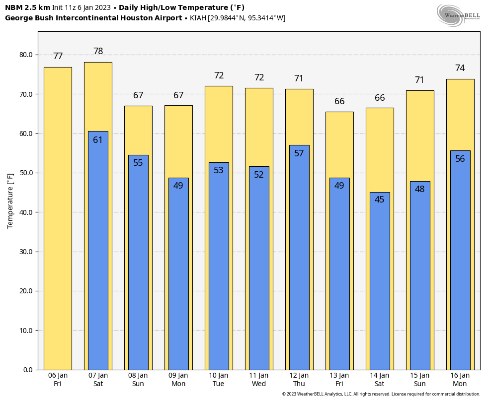
Southeast Texas should be able to squeeze out one more super nice day before clouds arrive this weekend. We may have a bit of a hazy morning with generally poor air quality. There’s even some locally dense fog south and west of Houston this morning. But it will eventually flip to sunshine. We’ll manage to climb into at least the mid-70s with just a slight nudge up in humidity by later today and tonight. Clouds should begin to break out tonight, which will keep temperatures a bit warmer than they have been of late. We’ll bottom out around 60, if not even a little warmer in spots.
Saturday
I would expect partly to mostly cloudy skies tomorrow. If you have morning plans, it should be mostly fine, though a few isolated showers may begin to break out in spots by mid or late morning. If you have afternoon plans, more showers will develop, especially toward the north and west of Houston. So you may dodge raindrops. That should become a little more widespread Saturday evening, along with a slight chance of thunder. Temperatures will jump well into the 70s to near 80 degrees tomorrow before dropping back into the 50s tomorrow night.
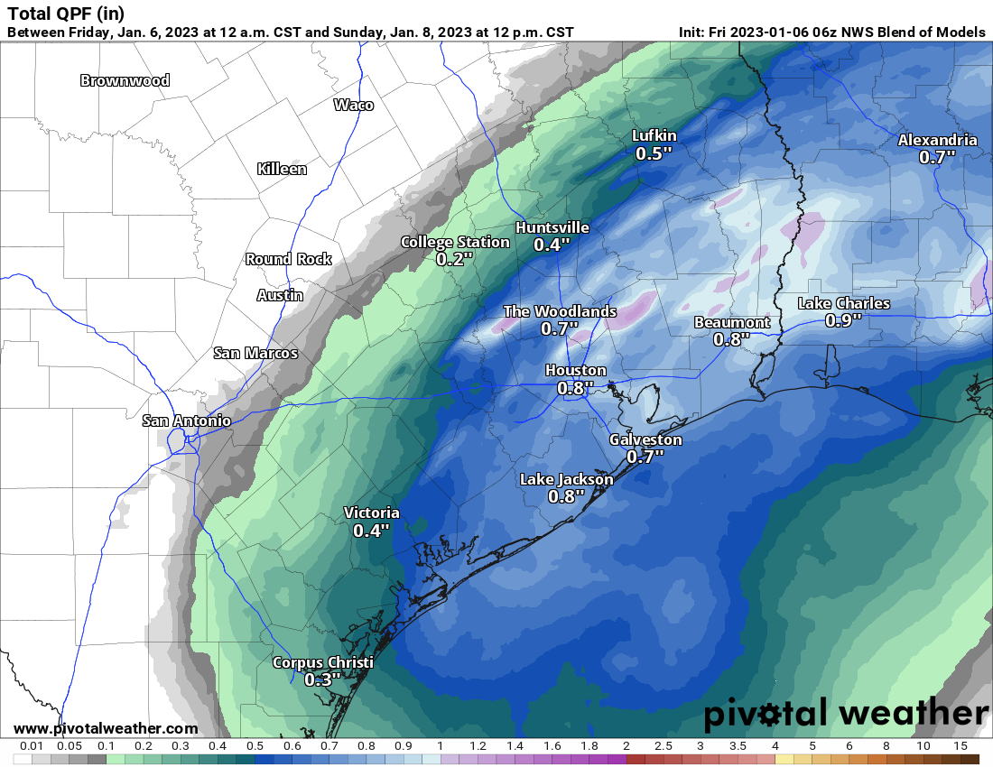
Rain totals may be held back some due to the scattered nature of the storms, but most of us will get at least some rain, with an average of a half-inch to three-quarters of an inch. Some may see less, and others could see as much as 2 or 3 inches in the most steady storms.
Sunday
Expect the inverse of Saturday: Some morning showers south and east of Houston but then decreasing clouds and increasing sunshine. It will be a good 10 to 15 degrees cooler on Sunday, with highs in the mid-60s.
Early next week
We may be in and out of clouds or some patchy fog on Monday and Tuesday into Wednesday. Other than that, it will be generally fair and mild. We think. With the weekend front sort of parked offshore, some coastal areas may see a few showers. Either way, it looks like a mostly quiet period, with increasing temperatures. We’ll warm from the mid to upper 60s Monday into the mid-70s by Wednesday, with morning lows generally in the 50s or upper-40s. Not bad for January.
Late next week and beyond
The next front in line is penciled in for Thursday. That should come with some showers or a thunderstorm, but it’s still a bit soon to speculate on how widespread any rain will be. More importantly, that front ushers in what should be our coolest air mass of 2023, with lows in the 40s by Friday, Saturday, and probably Sunday.
Our outlook for the Houston Marathon has held fairly steady this week. Today it looks like morning 40s, quickly rising into the 50s and low-60s with light winds and dry weather. A lot can change in 9 days, but right now, we’re sitting in a decent spot.
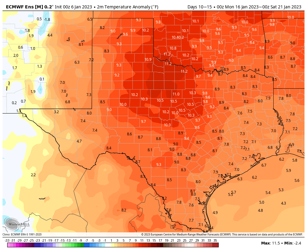
It appears that any cool weather will be short-lived however, as we expect a pretty significant warm up after Sunday next weekend. We have pretty healthy model agreement on temperatures warming deep into the 70s as the weather pattern amplifies warmer over us for several days the week of the 16th.


Can you comment any more on air quality? The last 3 mornings, Apple weather (who gets their data from breezometer) rated the air quality as “unhealthy” with AQIs in the 200-300 range. This is much worse than I’ve ever seen it register. However, checking other sources the AQI is much lower, (in the 60s or 70s) so I’m wondering if there’s some kind of data problem with breezometer?
Well, winter was good while it “lasted”.
Good grief, it was windy out on the Barker Reservoir today for a bike ride, almost gale force.
6jan23. 1245p
Thank you for the finally detailed weather information, as usual this morning. Possibly the rain in the evening, associated with thunder storms could be colder due to the altitude of its formation. In the face of intended outdoor activity tomorrow, I wonder what is the possibility of warmer feeling showers earlier in the day for the rain on Saturday afternoon north and west of Houston?
Regards,
TE
Re above evidence that Siri can misspell near homophones faster better than I can edit- finely, not finally.
TE