We certainly have not been in a true “drought” this summer, but at times, we’ve flirted with some extended dry periods. We seem to be in one of those now. Over the last 60 days, we have seen mixed results in the rainfall department in our area.
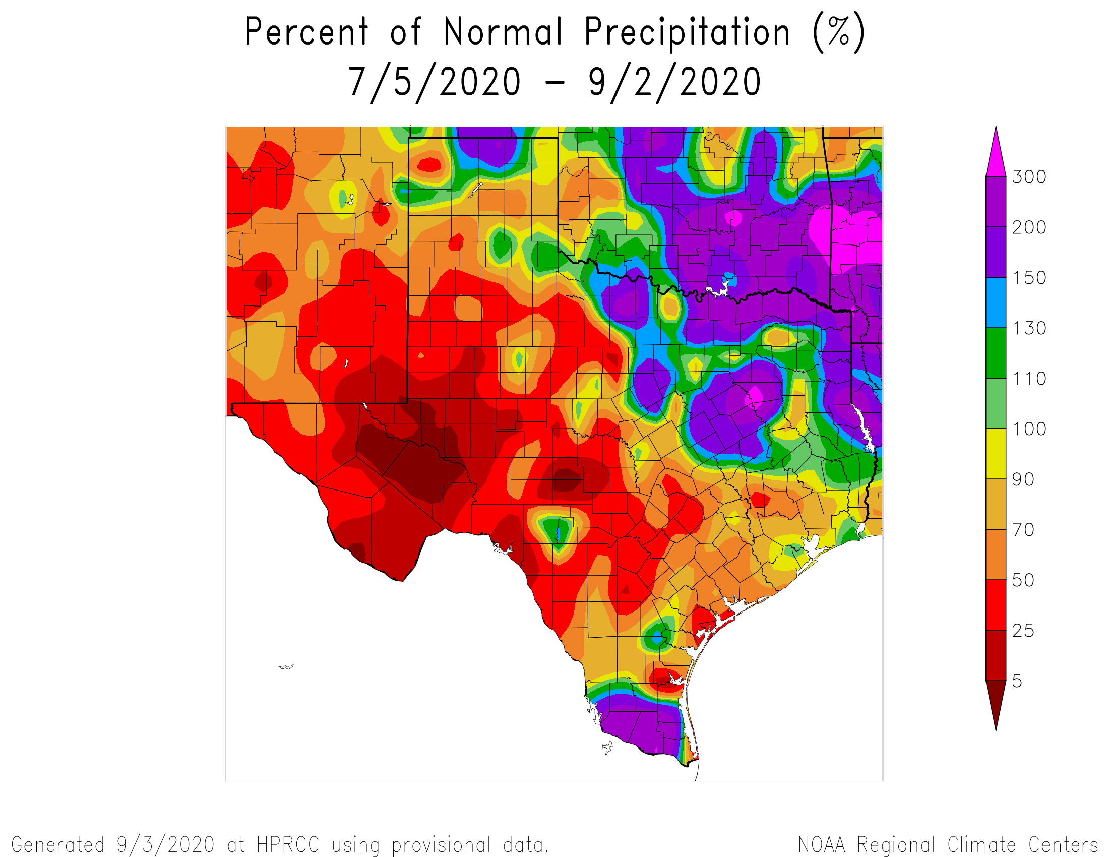
Parts of the Houston area, particularly down toward Hobby and Clear Lake have seen near average rainfall over the last two months. But, if you go up into western Montgomery County, some places have seen less the 50-percent of normal rainfall. Most of the Houston area is running drier than normal, and while parts of Texas have seen decent rainfall this week, most of Greater Houston has not. At least many of us will see a little rain in the next couple days, as we try to decipher the potential cold front riddle for next week.
Today
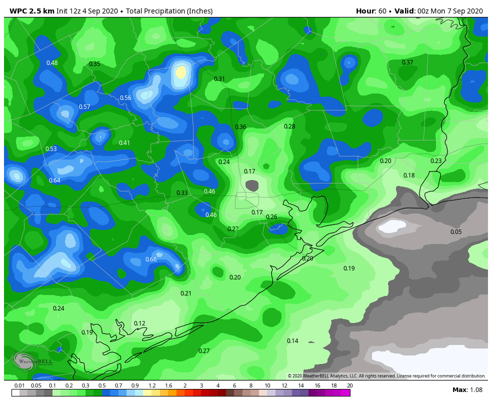
If you’re like me, perhaps you were woken up by thunder at 4:15 or so this morning. There have been a few storms focused mainly on the east and north sides of the city so far today. Places like Baytown, Pasadena, and Galena Park have seen around or above a half-inch of rain from those showers.
The rest of today will be characterized by scattered showers and storms. In trying to pinpoint any sort of rhyme or reason to how they’ll behave today, it would seem that they may try to focus in the Highway 59/I-69 corridor or just south this morning before slowly focusing more north and west as the day wears on.
Some of you won’t see any rain. Others could pick up an inch or two with some heavier downpours possible. Most of us will see slightly cooler weather today. Humidity will remain quite high, however, so don’t expect any sort of comfort in the Houston area. But, hey, at least Galveston finally dropped below 87 degrees this morning. Look for highs in the lower 90s and heat index values again jumping above 100 degrees, albeit somewhat less oppressive than earlier this week.
Weekend
Both weekend days will carry at least a chance of showers or a thunderstorm. As low pressure in the upper atmosphere gradually weakens and slips away, we’ll see a little less support for storms than perhaps we see today. Look for scattered showers both days, but with gradually less coverage. Many areas may not see much rain at all this weekend. Right now, places away from the coast look to have higher odds of rain, with a gradual shift south and west on Sunday.
Total rainfall when all is said and done will likely average around a quarter to half-inch of rain for most of the area. Again, some will see less, some a bit more. That’s just the nature of these types of setups. High temperatures will be in the low- to mid-90s this weekend, with our uncomfortably warm overnights continuing.

Monday & Tuesday
Labor Day will be another hot and humid one, with only a slight chance of a shower or storm. Look for 90s and morning 70s (80s at the coast). Tuesday will behave similarly, except by late Tuesday, we could see an increase in support for showers or storms, especially north and west of Houston.
Cold front conundrum
I wish I could tell you definitively today whether or not we’re going to get that cold front next week, but alas, the modeling is still all over the place. There has been a lot made about the GFS vs. the Euro, and indeed if you look at the operational (deterministic) versions of the models, the GFS quite clearly pushes the front through Texas, while the European (ECMWF) stalls it to our west. Here are their individual temperature anomaly forecasts for Thursday morning.
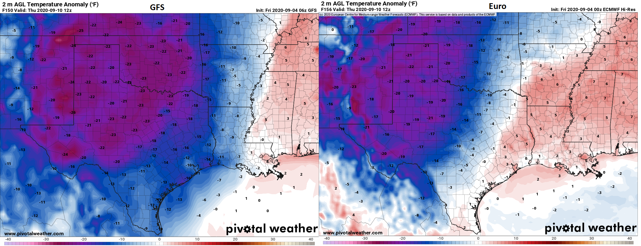
The GFS has the front clear across Louisiana by then, while the Euro holds it up between I-35 and I-45. If you look at the European ensemble mean, however, there is still support for something closer to the GFS solution. We are in a real pickle here. The time of year strongly argues that the operational Euro is probably correct here, and any sort of cooling would be weak. It seems to have some support from the Canadian model as well. On the flip side, the GFS shows the front, the new version of the GFS shows the front, and the European ensemble shows the front. I can tell you honestly that this is a very difficult one to sort out, and while I would not be lining up to support the GFS outcome here, I think something between the two operational models may be a reasonable compromise at this time. What does that look like? Cooler temperatures are likely, but they won’t be “run out and buy all the pumpkin spice stuff” type of temperatures. We’ll watch through the weekend.
Tropics
Quick note on the elephant in the room which is that the National Hurricane Center maps are colorful today.
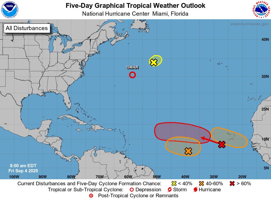
They’re highlighting three deep Atlantic systems with chances of development ranging from 40 to 70 percent over the next five days. While all of these areas are ones to keep tabs on, at this point there is nothing in any reliable modeling that suggests any of these will make it to the Gulf. That obviously could change, but even if it does, we have over a week to watch what happens here. At this point, we’re not too worried however. More on this for you Tuesday in our weekly tropical update.
Front, front, front, front… keep chanting everyone…. front, front…
I heard the thunder very early this morning, but it didn’t rain at all. This weekend is 3 days.
This is like a weather haiku.
Speaking of haikus, there’s a Facebook and Instagram page called Houston Daily Weather Haiku if you’re into that kind of thing 🙂
Take a peek at the Caribbean this morning…
I’ll take the relief if the front makes, it, but even if it does, won’t temps still be back to the 100s in a couple of days? This is September, after all—August gets all the press, but September is the hottest, stickiest garbage-month of them all.
I disagree, August is by far the worst and September traditionally begins to show signs of cooling. I work in a refinery and when we plan turnarounds, we often intentionally plan for them to begin in the later half of September because it’s notably cooler than the prior months.
Does pumpkin spice stuff burn well and give off a lot of heat? It’s going to have to be pretty darn cold for me to buy that stuff…
I’m supporting the wave started by Blackhawks Fan,
Front, front, front, front
Front, front, front, front…
Front, front, front, c’mon front…..
Front front front front
I, too, woke up last night to the sound of thunder.
“How far off?” I sat and wondered.
Front, front, front, front! Doing a cool weather dance
Started humming a song from 1962
Ain’t it funny how the night moves…
Front, front, front, front, front.
Front, front, front, front, front, front, front, front.
Front, front, front, front, front.
Ain’t it funny how the night moves… ehh SQLGeek?
Front, front, front, front, front.
With Autumn closing in. 😉
SQLGeek — Nice ending to the day’s forecast, and song.
Front, front, front, front….
(and agree: September here is the worst: the sun starting to swing south in the sky and the changing daylight patterns say “autumn!” but the heat and humidity say “Summer!” and, having spent more of my life in the East and Midwest, where September temperatures start to fall quickly, the September light/temp contradictions HERE are very discombobulating to me–and that’s still the case though we’ve now lived in the Houston area almost 16 years!)
Front, front, front, front….
How much credence (if any) would you give to the idea that the global models are struggling with tropical systems and fronts due to climate change? It seems like most if not all of the global models are struggling, and I wonder how much of it is due to global changes in long-term climatic patterns?
So just to be clear, next week’s problem is a common one we encounter. The GFS has always had too progressive of a bias with cold fronts, and the Euro tends to be warm biased. So your answer key often lies in between. There’s nothing new there. As far as the broader problem, I don’t view it as an issue with climate change. At least, you can’t say that based on poor performance over the last 6-8 months or whatever. I think this year is unique in the sense that we’re dealing with significantly fewer aircraft observations. That’s likely hurting model output, perhaps significantly. It also doesn’t help that we had a record strong polar vortex this past winter, which likely impacted pre-pandemic verification. Models can become a little more unwieldy when you inject significantly anomalous things (say like a super typhoon in the Western Pacific or a record strong/weak polar vortex in the Arctic). You could perhaps argue that as those events become more common, tied in part to climate change, then the models should suffer more often also, but I think it’s too soon for that. The models have been struggling in non-anomalous environments lately too, and I think that’s more a function of the current observational inputs/pandemic than anything. I also think some recent “improvements” in models have degraded their tropical forecasting abilities too, especially in the case of the Euro. A long way of saying “it’s complicated.”
Model improvements have degraded forecasting abilities? I like how you put quotation marks around the word then.
Has the Euro improved significantly in other areas then, to offset this tropical blindness?
Front, front, front, front….
Apparently it has. Though I find that some predictable biases it used to have are no longer as predictable. Sometimes a faulty model you know is better than an improved model you don’t know. I think that’s where you run into the battle between statistically successful and operationally useful.
Just to be different….
Rear, rear, rear, rear….
Jim, you’ll be the scapegoat if the cold FRONT, FRONT, FRONT, FRONT doesn’t appear.
In other words, typical Houston weather in September – hot, humid, muggy and YUCK. Nothing new these days. Ugh. Front, front, front………
FRONT FRONT FRONT