Today, there has been a lot of chatter on social media about the potential for the remnants of Harvey to move offshore into the Gulf of Mexico by around Monday, whereupon it might strengthen into a hurricane again and make a second landfall over Houston. This is obviously a scary scenario, but frankly it’s not one we’re losing too much sleep about here. The main threat for Houston remains heavy rains and inland flooding. But let’s discuss this anyway, because we’ve had a lot of questions regarding it.
For readers who been with us a few days, you’ll recall that we’ve been discussing the “Euro special” scenario since Thursday. The idea is that a drifting Harvey would wander southeast this weekend, and move back over the Gulf of Mexico. That seems increasingly likely to occur, although it’s far from locked in. Even with the European model, which has most consistently held to this solution, only about two-thirds of the ensemble members have the storm offshore on Tuesday.
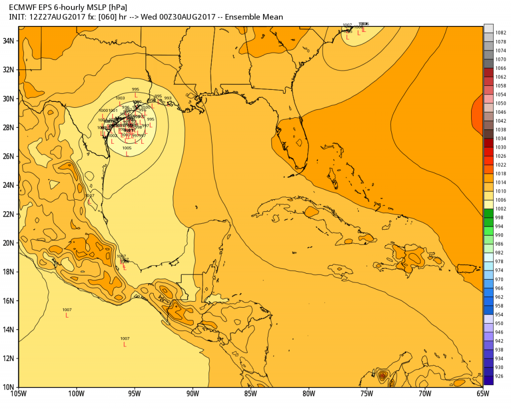
While the center may move offshore for a day or two, the fact remains that Harvey no longer has an inner core, and what remains of it will deteriorate further while it is over land Sunday and at least part of Monday. This, along with its proximity to land, should limit intensification. In the official National Hurricane Center forecast released Sunday afternoon, hurricane scientists predicted that it may attain 45 mph winds offshore, but was not likely to strengthen further.

“All of the global models show some slight deepening of the system after it moves over water, but given the lack of an inner core, significant strengthening is not anticipated,” forecaster Daniel Brown wrote. “Although a tropical storm watch has been issued, which may need to be extended eastward along the upper Texas and southwest Louisiana coast tonight, heavy rainfall and life-threatening flooding continue to the primary threats.”
Now there is some probability that by briefly moving offshore, Harvey could slightly increase (by bringing southerly winds to the coast) the storm surge that has been limiting the ability of Houston’s bayous to drain. And we may see a period of minimal tropical storm force winds by next Tuesday or Wednesday. But to say a hurricane is going to make a second landfall in Houston (a sexy, clicky thing to say if one’s goal is to capture widespread attention on social media), and all the fear that entails, strikes us as unjustified at this time. If our thinking on that changes, we will of course let you know immediately.
By far the biggest threat remains additional rainfall from Harvey, and forecasters expect and additional 15 to 25 inches of rainfall during the next three or four days. If this falls over areas of Houston already hard hit by Harvey, well, we don’t need to tell you how bad that will be.
We’ll be back later this evening to keep you updated on the forecast.
Posted at 5:35pm CT on Sunday by Eric
Army Core of engineers is planning on releasing water out of Adicks and Barker Dams how will this affect Jersey Village / Cooperfield area?
I’m sorry, I cannot say.
Thanks for your hard work, time and energy. Really appreciate the straightforward and thoughtful information. This is all so emotionally exhausting for everyone. Prayers to each of you and the greater Houston area.
@Catalina,
I would think that the Copperfield subdivision area would feel a bit more at ease knowing that the creeks flowing through are being allowed to move forward somewhat. Jersey Village? Different water shed.
I live by the Addicks Dam. The release shouldn’t affect Jersey Village at all. The water is being released into Buffalo Bayou from its south side through Langham Creek. You are in a completely different direction and a whole different watershed. If anything, it would pull water away from your area.
You are completely 100% wrong. Stop spreading false information. What makes you think you’re qualified to opine on what’s going to happen? Are you really that confident in your inuition? The release will send water over both ends. It will affect upstream and downstream. And by 4 am Monday, it will start affecting non-government properties. Source: army corp of eng
This statement seems to be more or less in line with the Corps statement. Release no. 17-031, posted 8/28/2017
“Zetterstrom noted that the water in the reservoirs…” (Addicks and Barker)…”will flow into the Buffalo Bayou whether it goes through the gates or around the end of the dams.”
Col. Lars Zetterstrom, Galveston District commander
So unless there is a specific path for the water to flow from across 290 into another watershed, it will not impact White Oak Bayou.
My husband is a supervisor with the Core and says it can definitely effect JV and C.
Charla, can you give more info? I also read the upstream areas could be affected. I’m near buffalo bayou, so I’m thinking I would be affected downstream, but I’m confused as to how upstream would be impacted.
How so? Unless water runs uphill…
It won’t. The dams are to our south.
Hi Eric,
What are your thoughts on the talk of dry air moving in the core and weakening the rains?
We need some hope!
Hope you and your family are safe!
That’s something we’re certainly hoping for, but not expecting at this time.
You guys are my heroes. Thank you so much for all the information. It has been very comforting to me. You guys are no drama and just data.
I 100% agree with Diane. Thank you!! Your frequent posts have been so helpful.
thanks, Eric & team! I hope you & your families stay safe!
Thank God for you.
Add me to the list of grateful subscribers. As a new 6 month resident of the Houston area, I had no idea what to expect or where to get accurate information.
You do a great…and I mean great job. But trying to walk the line between informing and alarming is hard. On Tuesday or Wednesday last week I emailed that I was concerned (based on the consistency of the major models) that city leaders weren’t yet cognizant of the catastrophic potential. On Wednesday I emailed and said that while I didn’t want to be apocalyptic, I wondered whether you agreed that this had the potential to be Houston’s worst weather event. You responded no. Others, as I recall dismissed the idea out of hand.
Now, we have the potential for Harvey to have a return engagement as a strong tropical storm or hurricane. Earlier today this idea was dismissed as a social media hoax. It isn’t any more than the idea Harvey could be a disaster for Hoston. With the ground unbelievably saturated, strong sustained winds could topple trees, creating significant property damage and loss of power.
Yes, we need to deal with the awful situation at hand and rain is a bigger concern, but that doesn’t mean you should dismiss the reasonable probability that Harvey could have an evil second act.
Hurricanes aren’t evil.
Eric, Matt & Braniff,
Continued great work! Thank you!
Some reports that there will be a water release from Addicks Reservoir overnight. How will this impact the homes along Buffalo Bayou? Many already have water in or close. Any thoughts?
This is from last years Tax floods…
http://abc13.com/weather/weve-never-seen-this-much-water/1303369/
Great reports. Have helped us a lot in understanding what could/would happen during this incredible weather event
Wouldn’t that be a zombie sequel? Harvey was already an undead storm, wasn’t it?
If some tropical storm force winds are what we must take to finally get rid of this thing, so be it!
I was thinking that! It was supposed to be dead a week ago over the Yucatan. I think we need to stab it through the heart with garlic or something.
Appreciate your good work.
Hope all is well with you and yours.
The models are showing the heaviest rain on the west side of the forecasted storm center on Tue/Wed. Have always heard the heaviest rain would be on the north/east side. Can you explain?
Thanks for the updates! Hope things get better for Houston. We have been really lucky down here in Freeport/Lake Jackson area. Hardly any rain.
Exactly what I’ve been thinking. I don’t know how we got so lucky, and while I’m very grateful for that, it’s hard to see the devastation in Houston while the streets here are dry…
Cliquey, not clicky.
No. “Clicky” is correct when referring to the extremely use of “click bait” by any and all news organizations. The Weather Channel’s headlines were so full of clickbait, I deleted the app after having it for so many years. So sick of the hype regarding this or any storm. Media is brainwashing – most have already swallowed the pill a long time ago. Thanks for writing posts that are real, factual, and do not contain typical media hype with “clicky” headlines.
I love the work all of you are doing. Thank you for the honest facts.
(ps – cliquey, not clicky.)
I believe he meant “clicky”, as in “clickbait-y”.
I’m pretty sure he meant clicky as in click-bait.
No, I think Eric meant clicky like clickbait-y.
To my layman’s knowledge, I read that info and I think, that’s not good of course, but that’s only a foot or two at most, right? And over a 3-4 day period in which it’d be expected that some of the flood waters would’ve have receded, right?
So what am I missing? Is it something like that 10 inches of rain = 2 feet of flooding because of drainage problems?
But very very much more difficult now with oversaturated grounds and completely overwhelmed bayous, no? Plus occasional heavy rainfall rates like the guys have been saying. Still sounds super scary to me.
Yes, it’s all because Houston isn’t a completely flat, homogeneous surface. Because of concrete and structures that don’t allow water to absorb, loss of things like prairie grasses, and uneven terrain, it becomes disastrous surprisingly quickly. For example, I live at 610/59 at the galleria. Yesterday, we had about 16 inches of rain, and the ground outside my window went from 0 to 16 feet overnight. Drains get clogged, the ground gets saturated, so another 16 inches would certainly equal more than 16 feet, which would certainly equal disaster for me! So the damage in unevenly spread, but we are working on a contingency plan for sure.
one more time – Thank you Matt and Eric! Houston is lucky to have you. There once was this thing called The Weather Channel that I don’t miss at all since finding you guys! Sending everyone I know your way! It would be criminal not to.
We know the flash flood alert will go for days. Why do they keep reissuing for just a few hours? I want to leave emergency alerts on for tornados but not to be woken for repeats of the obvious.
I think that the Flash Flood Emergency alerts are only allowed for short time spans. Since we have a days long one, they have to keep reissuing.
You guys are doing a great job of weather reporting and analysis, and are the best in the city. Keep at it.
Our Bellaire street flooded early this morning and the water line has been creeping up the driveway all day. I expect the water to ooze into the first floor tonight — something that did not happen during Allison.
I will remember my county commissioner when he runs for re-election. The commissioners court has far too long paid lip service to flood control while doing just enough to keep the unwashed, flooded multitudes away from there doors. If the Dutch can come up with real solutions to flood control, why can’t oil-rich governments in Texas do the same?
I apologize if his has been asked already.
Lake Conroe is now releasing water into San Jacinto
Do you know how badly this will affect the areas around San Jacinto and lake Houston ?
Channel 2 was showing Harvey going back out to the gulf, picking up moisture, and coming back to dump 30 inches on Houston.
So glad you are here to give us the real story!
There is no “real story” until after the event has taken place. KPRC has their own model they run and it tends to be overly aggressive, which makes for good TV. Matt and Eric do a very good job of digesting the various models and and translating them into a few paragraphs that we can comprehend.
There are enough resources just a few clicks away that can answer the bulk of the questions posted on this site.
A minor comment. With so many updates, I think it would be helpful to put the approx time of the update into the headline if able. Thx for all of the info.
I think he’s referring to ‘click bait’ which would be ‘clicky’ not ‘cliquey’
Tornado warnings continue for many counties. Can you provide any information on how many twisters have actually formed over the last 58 hours?
Please comment on Jeff Linder’s comments on releases from Addicks damn!!!
Eric, you are the Joe Friday of meteorology. Your “Just the facts ma’am” reports are a. breath of fresh air in the field of weather prognostication. Thank you, thank you, thank you. Rock on, brother!
Does anyone have any information about where exactly will be affected when the release of the Barker and Addicks occur? My daughter and grandchildren (including a newborn) live in Green Trails at I-10 and Barker Cypress. I’m kinda freaking out right now
This afternoon in Rice Village area we had a few hours without rain. Water receded by ~2 inches. Is good news for the area!
I have to agree with Jeff. Any meteorologist knowing Houston’s history and seeing the rainfall predictions coming out Thursday and Friday and not sounding the alarm but instead discounting the possibility of catastrophic flooding was doing a disservice to Houston residents.
It finally sank into me to ignore all the official media and politicians and have my girlfriend leave La Porte late Friday afternoon and I left Friday evening. The one thing I have to thank the media for is that I have never experienced the freeways so empty. I am more worried about the coming days for La Porte then what has occurred so far.
Also it seems odd to complain about click bait headlines with a click bait headlines.