Another cold and frosty morning for the region, with a light freeze for areas north of Houston, including Conroe and Huntsville, and mid- to upper-30s in the city itself. We’ll now see a moderate warming trend through Thursday, before another (quite blustery, as it turns out) front pushes into the area. This weekend looks spectacular for December—especially Sunday.
Tuesday
After the chilly start today, we should warm into the lower or even mid-60s under mostly sunny skies. A wind shift to the southeast will aid in the warm-up, and this onshore flow will also keep temperatures tonight a good 10 to 15 degrees warmer than Monday night. Skies turn partly cloudy tonight.
Wednesday
As the onshore flow does its thing, we’ll see a corresponding increase in moisture levels, and our partly cloudy skies will become mostly cloudy. This should limit highs to the upper-60s during the daytime, and we likely won’t see much of a cooldown during the evening hours. Some light showers will be possible later during the afternoon or evening, but probably will hold off until later.

Wednesday night and Thursday
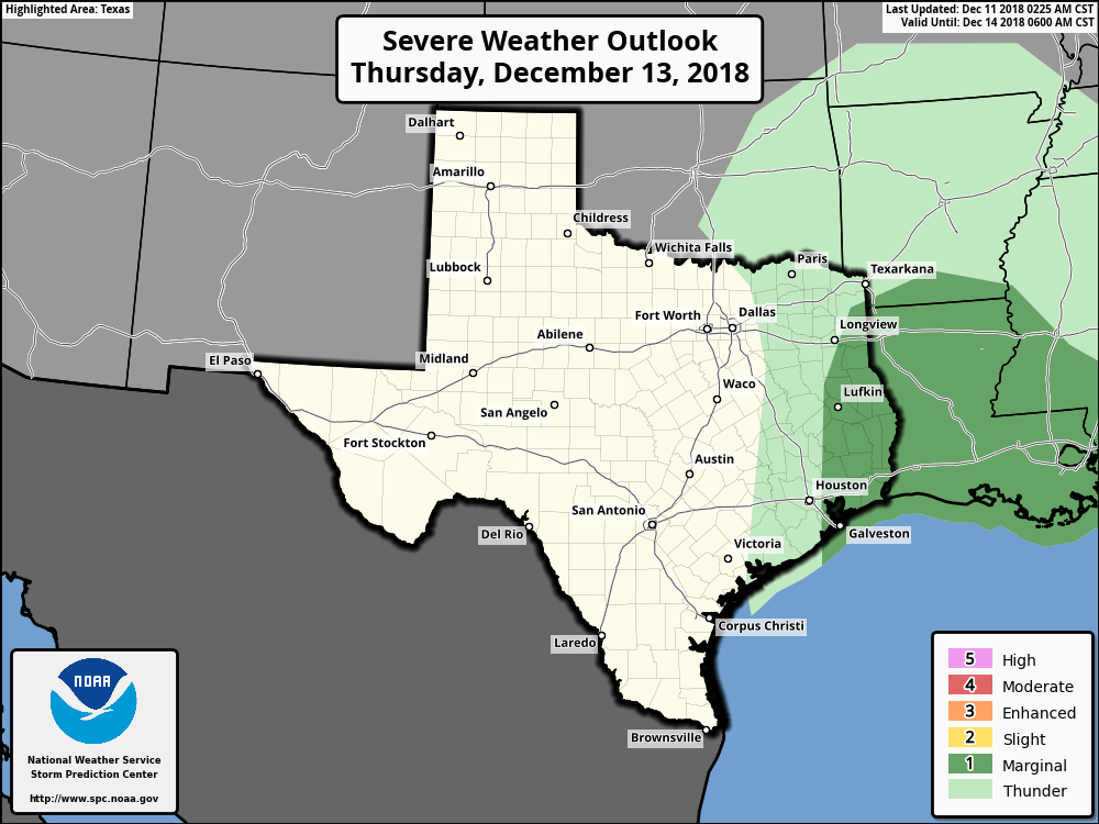
The combination of higher atmospheric moisture levels, an atmospheric disturbance moving up from Mexico, and a cold front moving down from the northwest will bring a chance of rainfall and (slight) chance of strong thunderstorms from Wednesday night through Thursday morning. For areas to the west (Sealy) and northwest (College Station) of the metro area, rain chances look best between midnight and sunrise on Thursday; and for the metro Houston area itself, from sunrise to noon Thursday.
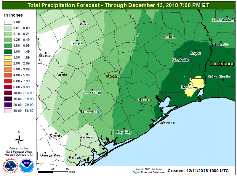
Weather models have gotten a bit more frisky with rain totals from this event, to the extent that we now anticipate that most of the region will probably receive 0.25 to 1 inch of rain, with the potential for more east of Houston. (This is also the region where severe weather is a bit more likely, but the overall probability of severe thunderstorms remains fairly low).
Rain showers could linger into the afternoon hours on Thursday, but a cold front should reach the area sometime during the afternoon hours and sweep the rainfall away. It will leave much colder conditions in its wake, and a tight pressure gradient that will produce strong offshore winds, perhaps gusting above 30 mph Thursday night. Lows will get into the low 40s for most of Houston.
Friday, Saturday, and Sunday
Partly sunny skies on Friday (highs in the 50s) will give way to mostly sunny weather this weekend. Look for highs in the low 60s on Saturday, and mid-60s on Sunday. Overnight lows this weekend will generally be in the 40s—cooler inland and warmer along the coast.
Make your outdoor plans now.
Apart from Thursday morning, splendid weather! Makes it actually worth living here for a change.
Thanks Eric.
Do you see any major impact on the already flooded rivers?
Not really; I’m hoping most of the rains will be east of the impacted rivers.
I fly out of Hobby at 6:30 Thursday morning. Should I anticipate any delays?
It depends on the timing of the line of storms, but it’s possible you may see a relatively short delay.