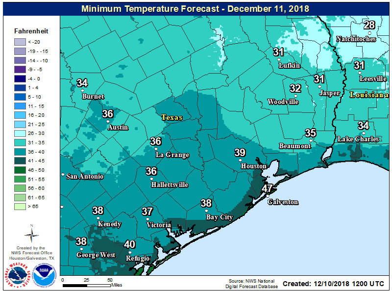
After an oh-so-gray weekend, skies have finally cleared out overnight and this has allowed temperatures to fall to near-freezing north of Houston, into the upper 30s for most of the city, and mid-40s along the coast. With light northwesterly winds out there, it’s quite cold this morning.
Monday
High pressure will dominate our weather today, and although skies will be mostly sunny, temperatures probably won’t rise much out of the mid-50s. Low temperatures on Monday night should be similar to Sunday night, so it will be another one for fireplaces and heaters.
Tuesday
This should be another sunny day, and start out a lot like Monday. However, as high pressure moves off, winds will return from the south or southeast later in the day, and this should moderate overnight temperatures. Lows Tuesday night probably will not fall below 50 degrees as the warmer Gulf of Mexico air mass exerts its influence.

Wednesday and Thursday
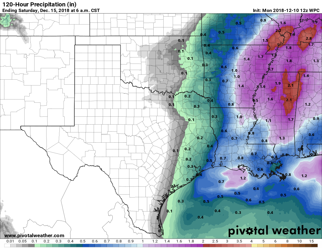
Under the influence of rising moisture levels, and a storm system approaching from the west, rain chances will return for the second half of the work week.
Wednesday, itself, probably won’t see much in the way of rainfall with mostly cloudy skies and highs near 70. By Wednesday night, however, rain and thunderstorm chances will kick up over Houston, and remain around 50 percent or slightly above through around noon on Thursday by which time a robust cold front will push through the region. Accumulations likely will only measure a few tenths of an inch for most people. We will see some brisk winds in the wake of this front, with gusts up to 30 mph later Thursday and into Friday morning.
Friday
Mostly cloudy and cooler, with highs in the mid-50s, most likely, and overnight lows in the upper 30s for inland areas Friday night, and lower 40s for closer to the coast.
Saturday and Sunday
As of now, the weekend looks quite nice for mid-December. Highs, generally, should be in the 60s with partly to mostly sunny skies.
Christmas forecast
It’s way too early to have any confidence in the forecast for Christmas Day in Houston. However, I checked the ensemble model outputs just for fun. Right now both the GFS and European models a predicting a high temperature in the low 50s, with a most probably range from the mid-40s to around 60 degrees. Perhaps this won’t be a shorts and short-sleeves Christmas after all? We’ll peek at the ensembles again later this week.
No snow this year??
Snow only happens after a hurricane hits the area.
Snow usually doesn’t occur until later in December, or January, so it’s impossible to say whether we’ll get measureable snow.
Also, we already did record a smidge of snowfall this year!
https://spacecityweather.com/houston-records-earliest-snow-faces-a-second-freezing-night/
The Brazos River will be at 41.8 on Wednesday near Richmond. Do you think the river will remain within its banks with receiving only tenths of an inch of rain?
Thank you for the Christmas forecast. Please do another one in a few days. Depending on the forecast here, we are deciding whether to go North several days before Christmas, or go closer to Christmas and stay after. We want those who will care for our livestock here to have the best possible weather.
😎🌴🌴🌴🍹 I hope there’s a blizzard on Christmas Day! I’ll be in Cabo! 😎🌴🌴🌴🍹
LOL
Eric,
Glad you saw my humor. I’ve lived in “blizzard country,” but the last 20 years in this area. I certainly don’t want the fine folks of Houston to have to deal with a blizzard.