We’ve got lots to discuss about the week of weather ahead, so let’s get right to it this morning.
TODAY
We’ll see mostly cloudy conditions today as the wind ramps up out of the south, gusting as high as 25 mph. Temperatures will climb into the mid-70s. Rain chances will remain fairly low, however, due to a capping inversion. Expect lows tonight in the upper 60s.
TUESDAY
Those southerly winds will continue throughout Monday night and into Tuesday morning, raising moisture levels in the atmosphere. They will also increase tides along the coast by as much as 3 to 4 feet above normal, and the National Weather Service has issued a Coastal Flood Advisory. We should see increasing coverage of light to moderate rain during the afternoon hours on Tuesday, but the bigger threat comes Tuesday night.
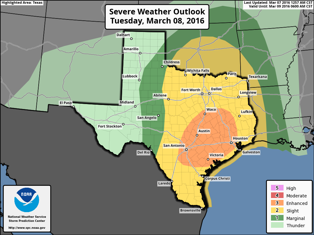
As you can see in the map above, much of Texas, including most of the Houston area, will fall under an “enhanced” probability for severe weather on Tuesday and (for Houston) especially Tuesday night. Conditions in the atmosphere should allow for the creation of squall lines, including the threat of wind gusts and possibly a few tornadoes.
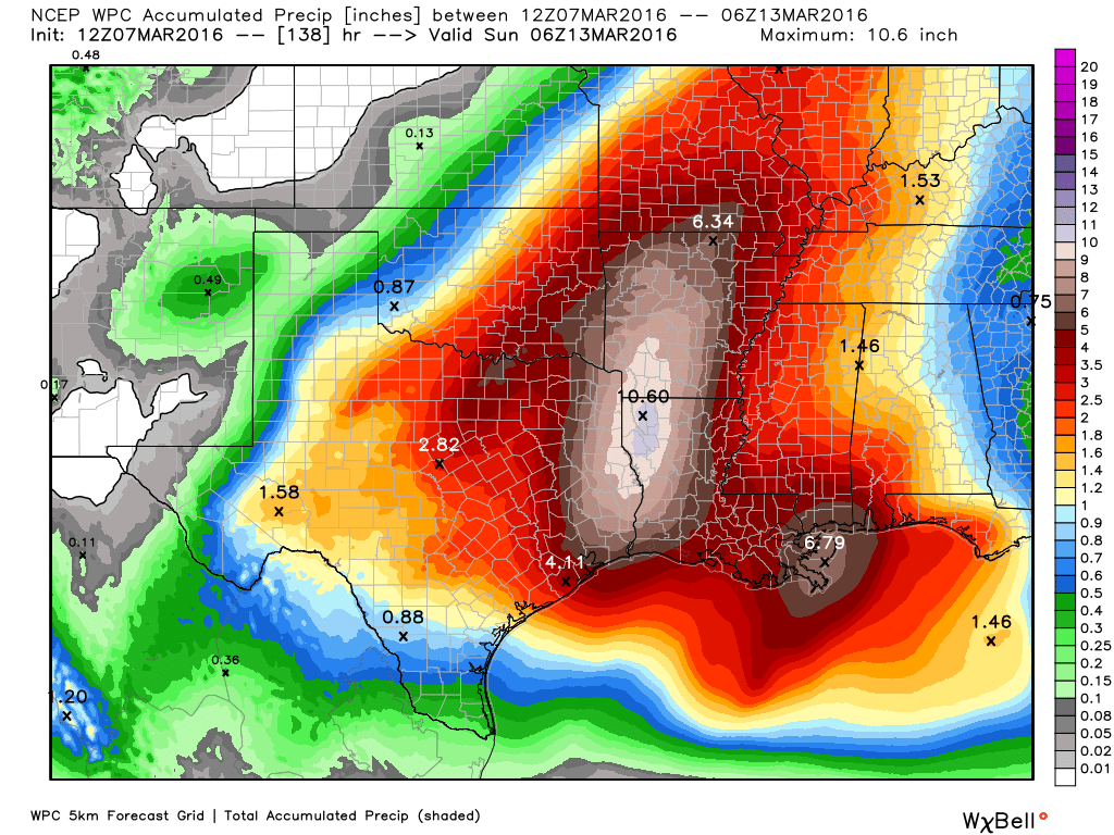
In addition a flash flood watch is likely to be issued by the National Weather Service, as there will be areas of intense rain within these squall lines. On average I’d expect most of the Houston region to see between 2 to 5 inches of rain between Tuesday evening and Wednesday morning. It’s not clear when the heaviest rain will arrive—perhaps sometime around midnight or shortly thereafter. Some areas will very likely see street flooding, but I’m not certain how widespread that flooding will be. It will depend upon rainfall rates.
WEDNESDAY
Needless to say there’s the potential for a mess on the roads Wednesday morning, and this is something that will have to be watched closely. Make sure to add a little extra time to check conditions before venturing out. Although It’s difficult to say, I’d expect rain to continue on Wednesday, although it will probably be lighter than what we see late Tuesday and early Wednesday morning.
THURSDAY
We might see a bit of a break on Thursday, with only scattered, moderate rain showers but it’s hard to say for sure. Temperatures, as they will for much of this week, should again rise into the 70s and won’t dip down much at night.
FRIDAY
This is another day of potential concern as the upper-level low pressure system that’s been causing all of this rain will move directly overhead. This may very well bring additional heavy rain showers into the region although it’s hard to have too much confidence in what will happen Friday before we see what happens Tuesday night and Wednesday.
THE WEEKEND
By the time we get to the weekend we should see drying conditions, with rain showers ending and pleasant days in the low- to mid-70s. Remarkably, our streak of nice weekends will probably continue. We just have to get there first.
Rest assured that throughout the week Matt and I will have you covered.
Posted at 6:55 a.m. CT Monday
Mom is driving in from Beaumont tomorrow. What time do you expect the rains to start?
On the upside, the rain is good for the wildflowers.
Eric, I passed your Friday post on to my Stats Major son and he said that assuming a Standard Normal Distribution that anything above 5 Standard Deviations would by about 1 in a Billion… That is a lot of storms before you would have something this much of an outlier…
You all are scaring me…should we get out of here?
Don’t be scared. We get heavy rain from time to time in Houston. It’s best to remain put when the heaviest rains are falling, but once the rains end the streets will clear quickly.
When do you think will be the main threat for tornadoes? Ahead of the main squall line (so late afternoon/early evening from the looks of it), or is it more of a continuous threat?
I’m guessing during the overnight hours on Tuesday night/early Wednesday.