In this morning’s post, I wrote that there was the “potential” for storms and heavy rainfall today, but we didn’t have any confidence in whether it would materialize or not. Fortunately, so far the storms have not materialized.
Our biggest concern today has been a broad line of showers and thunderstorms moving eastward across central Texas today, associated with a cold front. High resolution modeling suggested this line would weaken as it approached the Houston area, and in fact that is what has happened, which is good for Houston. See the comparison below of radar images from earlier this afternoon.
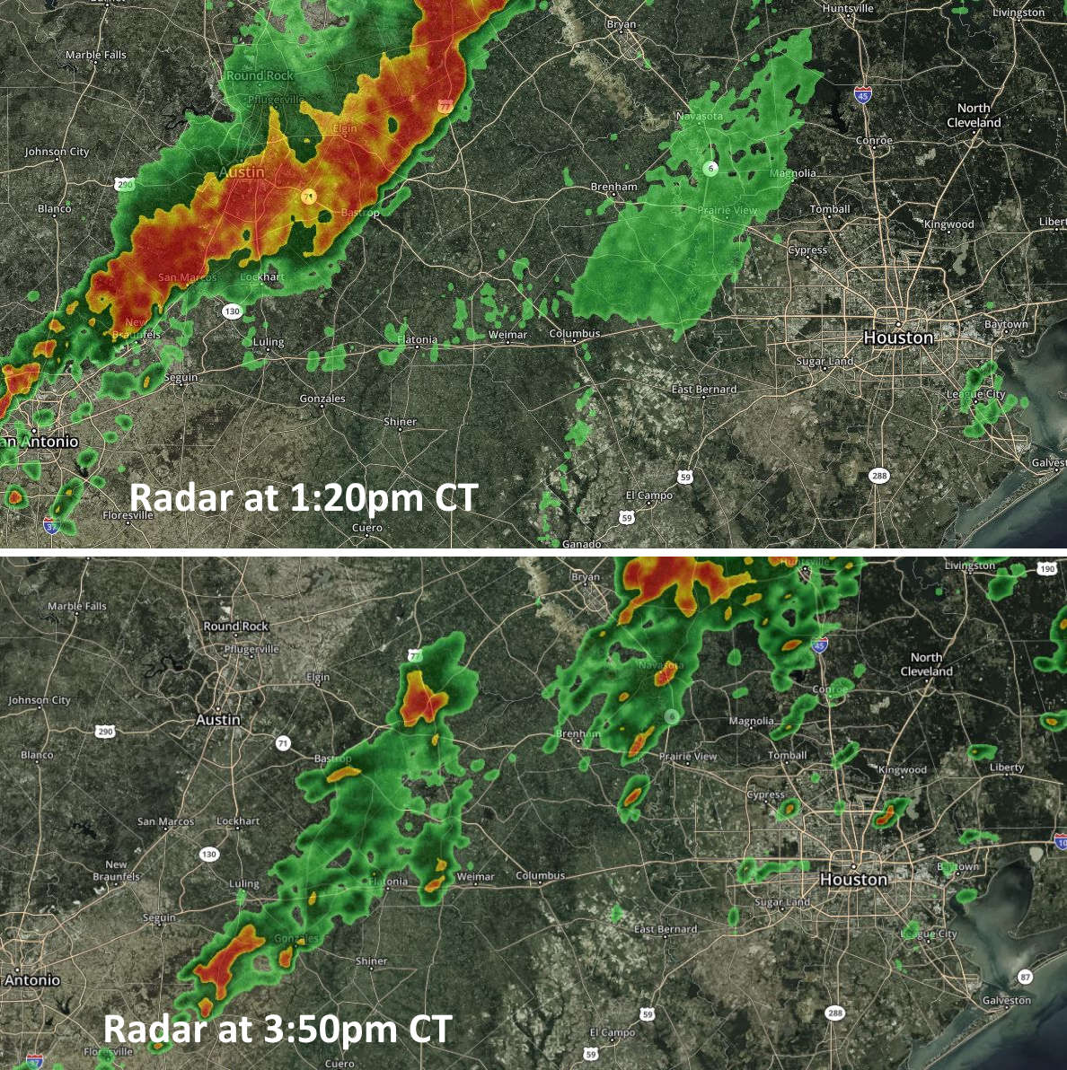
As this broken line of showers and thunderstorms moves into the Houston area this afternoon and evening, the most likely outcome is that the system does not get too organized over the city. The best chance of storms will probably come to the north and east of Bush Intercontinental Airport, and the good news is that the storms seem to be holding a fairly steady eastward motion which should help to limit storm totals. As a result I think most of the area will probably see less than 0.5 inches of rain later today and tonight, with a few unfortunate pockets perhaps picking up a quick 1 to 3 inches.
We expect a fairly calm start to Thursday, before more showers later Thursday into Friday morning, and then yet another round from Friday night into Saturday morning. We’ll have full coverage of that tomorrow morning.

Thank you for your great work. A tremendous service you’re doing for our area.
Thanks Eric and Matt for keeping us updated.
Looking forward to tomorrow’s forecast, as we have lots of friends and family driving in from Dallas for Rice gradation ceremonies Friday and Saturday :/
Thank you for such a timely update. You guys are so helpful!
Thanks for working overtime for us!
First time commenter doing so just to say thank you to Matt and Eric. You guys are the calm my soul needs in these storms.
So appreciate the extra work you do to keep us informed.
You forgo the hype for straightforward, accurate information. An unquestioned and laudable asset.
Thanks, Eric and Matt, for guiding us through another bout of storms with your level-headed, informative approach. You guys are truly a blessing to those of us who have flooded in the past.
Why have you guys played up this last round of weather to such an extreme degree? Is readership flagging? I’ve lived here my whole life and I just use this site for its honesty and succinct reporting, but there are people who struggle with anxiety after Harvey, thinking that every thunderstorm will flood them out. People who aren’t from around here and don’t know the difference between weatherman melodrama and real danger. You’ve earned their trust, and being dramatic causes them more stress than a few extra clicks are worth.
If I want to hear about how we’re at “threat level purple” or “danger zone 4” whatever, I’ll turn on the local news (kidding – I haven’t done that in more than a decade). Give us the facts and inform us on how they should most reasonably be interpreted. Another stunt like this and I’m back to NOAA.
Were we reading the same report?
This weather site is my go to every morning. Their scientific approach, sense of humor and humillity is refreshing. No hype, call it as they see it with provios as necessary (weather is always a fluid situation). Bravo and thank you!!!!