In brief: In today’s post we discuss storm and rain chances this week ahead of a robust front on Friday evening that will bring much cooler weather for this weekend. Sunday still looks spectacular.
Big picture
Houston will experience steadily increasing rain chances this week through Friday before a cold front pushes through and cools us down significantly for the weekend. The real questions for this week are the extent to which a capping inversion holds up (What is a cap? See our April Q&A post, which also published this morning) and how far fronts progress before Friday night.
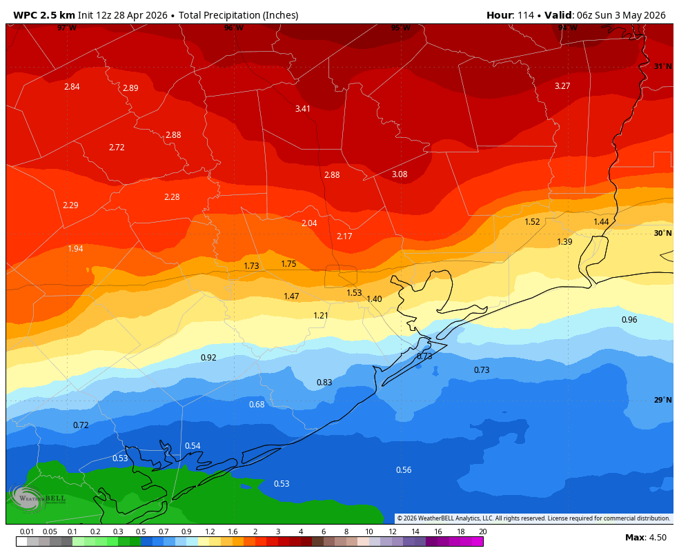
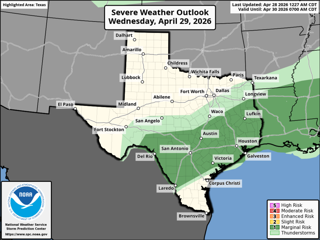
Anyway, although storms are somewhat unlikely today, they’re possible, and chances are a little higher on Wednesday. So be prepared for inclement weather (i.e. damaging winds, hail) even if it is fairly unlikely. Our best chance of rain will come on Friday, when a front advances toward, and then moves through Houston. Most of the region should pick up 1 to 2 inches of rain this week, with some areas north of Interstate 10 likely seeing more.
Tuesday
Today will be another warm and humid day, but how warm temperatures get will depend on the extent of sunshine this afternoon at your location. I believe most of us will probably get to at least partly sunny skies, if not more. This will allow high temperatures for inland areas to reach around 90 degrees, or perhaps even the low 90s, whereas coastal areas stall in the low- to mid-80s. Anyway, it will be plenty humid. I don’t think Houston will see much in the way of storms or precipitation, but they’re possible along and north of Highway 105 in Montgomery County. Lows tonight will only drop into the mid-70s.
Wednesday
On Wednesday a front will approach the area, but is likely to stall north of the city. In any case, this will help disturb the atmosphere and bring a chance of showers and thunderstorms into Houston, as well as some severe weather. The odds of this occurring are not super high, but there is probably a 20 percent chance of damaging winds, hail, and/or heavy rainfall during the daytime hours. Otherwise it will be another hot and humid day.
Thursday
This looks to be a mostly cloudy day with highs perhaps reaching only the mid-80s. Rain chances are probably in the 30 to 40 percent range, but the likelihood of severe weather is lower. Thursday night will see lows drop to around 70 degrees, probably.
Friday
This is still the day when we expect the most widespread showers and thunderstorms. The likelihood of severe weather looks fairly low, but heavy rainfall is possible. For most of us these showers, which are most likely during the daytime on Friday and into the evening hours, should be manageable. High temperatures on Friday may reach about 80 degrees, but the arrival of the front (likely during the late afternoon or evening) should cool things down overnight.
Saturday
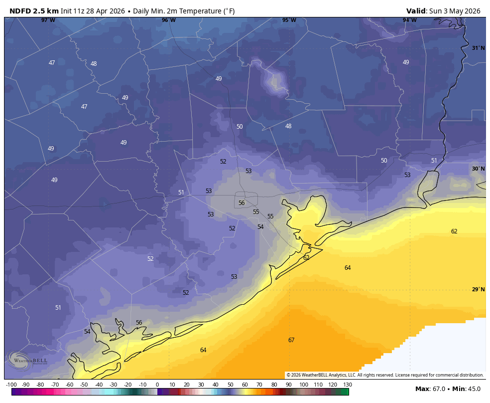
There is a lingering chance of rain on Saturday morning, but I am hopeful that showers will end before the weekend really gets going. That’s another way of saying, if you have outdoor activities planned for Saturday don’t not abandon hope yet. Saturday will start out cloudy and breezy, with northerly gusts up to 25 mph. By the afternoon hours, however, we could start to see some clearing of skies. Lows on Saturday night look chilly, possibly dropping into the mid-50s in Houston, with cooler conditions for outlying areas. We shall see.
Sunday
This still looks like a splendid day, with mostly sunny skies, highs in the 70s, and low humidity. Lows on Sunday night should drop into the 50s again.
Next week
Most of next week should see temperatures in the lower 80s, or thereabouts. I don’t think we’ll get as hot or as humid as we’ve been this week. Some rain chances may return during the second half of the week.
