We’ve had a lot of requests from out-of-state readers to continue providing our perspective on Hurricane Dorian—which threatens to make landfall in Florida as a major hurricane in three or four days time. To be clear, there is absolutely no threat to Houston or Texas.
As of 4pm CT on Thursday, Dorian had maximum sustained winds of 85mph, but based upon its satellite appearance it appears likely to undergo a bout of intensification soon. It will likely become a major hurricane within 24 hour, and then should experience more or less favorable atmospheric conditions for further intensification for several days as it passes north of the Bahamas and turns west toward Florida.
In looking at this afternoon’s weather model data, what is particular striking to me is the high degree of uncertainty about where Dorian is going to go by Sunday or Monday. There is, in fact, no guarantee it will even hit Florida. There is a non-zero chance it goes south of Miami, or turns north before reaching the Florida peninsula. A little while ago, I wrote a story for Ars Technica about this uncertainty, which is highlighted in this afternoon’s ensemble output from the European forecast model:
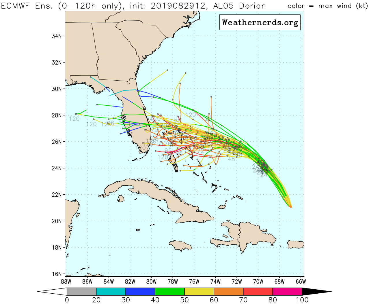
If you click the image above to enlarge it, the following explanation will probably be more clear. In any case, this plot shows the track of Dorian out to 120 hours, so that means its position as of Tuesday at 7am CT. Notice that there is a remarkable variance in the location of the “center” of Dorian in these roughly four dozen ensemble members. Yes, a reasonable amount of the ensemble members bring Dorian to the coast between Sunday and Tuesday, but some are far, far away. In some scenarios, Dorian turns north before even reaching Florida. This is reflective of the fact that steering currents for the storm are likely to become extremely weak by Saturday or so.
The 4pm CT Thursday track forecast from the National Hurricane Center captures this ambiguity. It encompasses the entire Florida peninsula within the five-day cone of uncertainty.
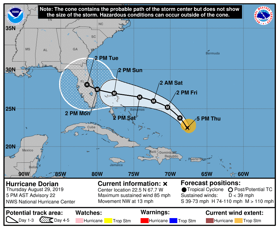
This is singularly unhelpful to the residents of the Sunshine State, who are staring down at the possibility of a major hurricane making landfall somewhere along the peninsula in three to four days. The time for preparations and evacuations is now, but it is hard to offer much in the way of specificity about where the worst storm surge, damaging winds, and inland rainfall will occur. Certainly a slow-moving storm will make the latter variable, rainfall, worse.
Matt and I will continue coverage of the storm through the Labor Day Weekend.

Thank you for your clear and concise (ie: not overly dramatic or fear mongering) coverage of this storm. I am a Florida native and my entire family is currently preparing for the unknown. I appreciate being able to track what’s happening from afar without being overly anxious about my loved ones.
Hi Eric,
Do you have any opinions regarding this article?
https://www.nature.com/articles/d41586-019-01305-4
Thank you for continuing to provide updates. I’m unfortunately on my way to Jacksonville this evening, staying until Sunday. It is nice to get updates from a site I trust.
I want to thank you for this and the coming reports. Our family just moved from Houston to Pittsburgh we lived in Houston for 6 years. I am here in Florida caring for my grandmother who is cognitively impaired and I am dealing with my father who is now in the hospital. Trying to decide when to evacuate and I think we will.
Thanks again for your report you guys are the best 💗
I am a former Houstonian who moved to Raleigh, NC a couple of months ago. The NHC and this site are still my go to weather site for Hurricane coverage. I do not know of another site quite like this one. Thanks for all that you do, Matt & Eric!
I have never commented before but with family from Florida to North Carolina and me in Galveston, I want to say thank you for “shooting straight ” and with no hype!
I don’t even watch the weather on tv any more, I just trust and depend on you and your team! THANK YOU!
Given the fact that the steering currents for Dorian are weak, it should come as no surprise that chaos theory rules and the outputs of the models are all over the place.
The real question is, without steering currents, what other factors determine where a storm goes?
It seems to me, given the extreme variability of the models, that we do not have a handle on which factors, if we know of any, predominant in situations like this.
One thing seems to be certain. Since the conditions are favorable for strengthening and Dorian is slowly moving over hot water, Dorian will become a very powerful storm.
We’re currently in NC and it’s great that you’re covering this for folks out of state. We share with abandon. As usual, thank you,
Thanks for sharing!