We saw a few showers in the area on Thursday, but for the most part it was a much calmer day than Wednesday. Some folks in our area have been bypassed by these showers more often than not lately, and it’s beginning to add up across much of Texas.
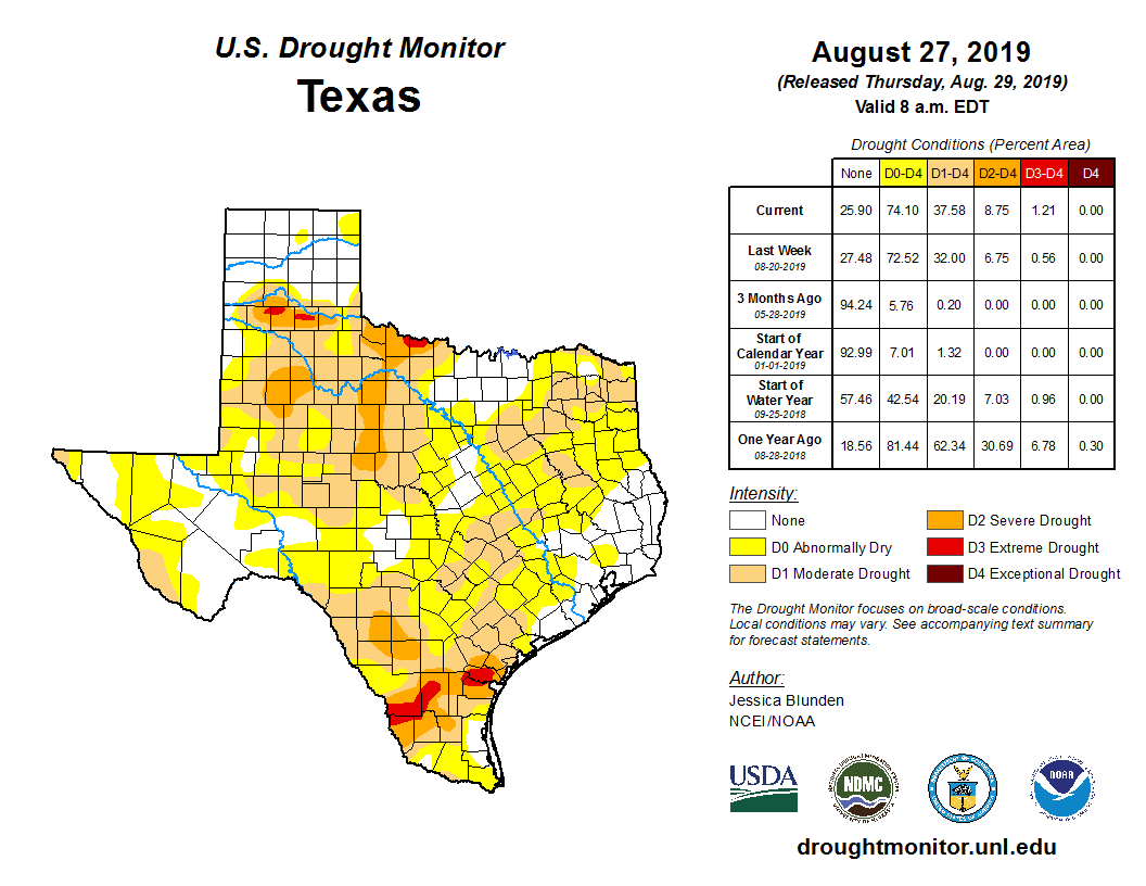
The latest drought update released on Thursday shows about 75 percent of Texas in abnormally dry or drought conditions. In the Houston area, as Eric so aptly described on Thursday, we’ve been playing “rainfall roulette” lately. Fort Bend County? Abnormally dry. Brazos Valley? Abnormally dry or in drought. Across Houston and southeast, it’s been almost comical, with Hobby Airport about 2 inches above normal this month thanks mostly to one big storm on August 19th. Galveston, meanwhile, is almost 2 inches below average for the month. IAH Airport? About an inch below normal.
Over the next couple days it would seem that just a few of us will see downpours, while many will stay dry, so drought will continue as an emerging storyline into September.
Today
Look for a typical summer day today: Sun, clouds, hot, and scattered hit or miss downpours. Rain will be mostly near the coast in the morning, especially toward Matagorda Bay. Showers should migrate inland for a lucky handful of communities in the afternoon. We should reach the mid-90s this afternoon, though it will feel 5 to 10 degrees hotter than that.
Weekend
Both Saturday and Sunday look partly to mostly sunny and hot. Morning lows will start off in the mid- to upper-70s, while daytime highs should easily peak in the mid-90s. Rain chances? The better chance is on Saturday, but even that will just be a handful of isolated showers. I would anticipate a mostly dry weekend.

Gulf tropical wave and early next week
Weather modeling has started to come to a consensus on the tropical wave in the Gulf next week, and it suggests that the core of it should be directed into Mexico, with an outside shot at weak, low-end development before it comes ashore. So Monday and Tuesday could feature a few showers in the southern parts of our area, with the highest chances along the coast from Galveston through Matagorda Bay.
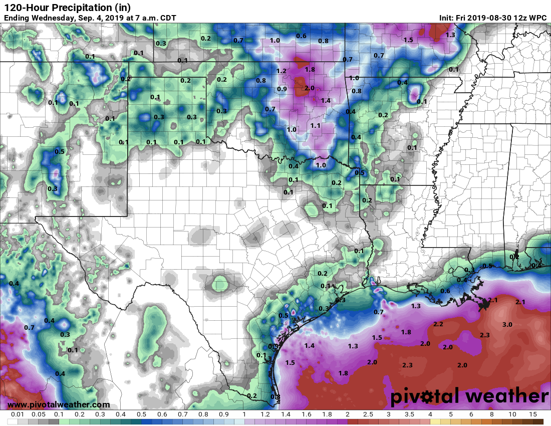
Don’t confuse “highest” with “high” rain chances, however. The best opportunity for steadier rains will be all the way down along the Coastal Bend south into the Rio Grande Valley and offshore.Look for temperatures in the mid-90s by day and upper-70s to near 80 degrees by night.
Later next week
One of the reasons Hurricane Dorian’s track (see below) is so complicated is because high pressure in the upper atmosphere over California today is going to migrate to the Four Corners region this weekend, and then to the Southern Plains by midweek next week. What does that mean for us? It probably means a gentle reminder that September is not an autumn month in Southeast Texas. We should see some pretty substantial hot weather late next week and weekend, along with very, very limited rain chances. As we begin pumpkin spice latte pray for a cold front season here, we sadly are not seeing much hope for one of those anytime soon.
High temperatures next Thursday through Saturday could be around 100° or so, with lows in the upper-70s to near 80° again.
Hurricane Dorian
Dorian is a formidable category 2 hurricane this morning, with maximum sustained winds around 105 mph.
Dorian has encountered some wind shear and may continue to have to fight off some shear in the coming days. Either way, it’s expected to become a major hurricane before long, and folks in Florida should prepare for a major hurricane impact.
In terms of track, Dorian has begun to pivot to the west as expected and will now crawl along toward the northern Bahamas. Eric pointed out a good bit about the track forecast uncertainty yesterday evening. Weather modeling overnight started to perhaps slowly come to a slight consensus in bringing Dorian close to the Florida coast, if not just onshore, with the highest risk of a landfall somewhere between Cape Canaveral and about Boca Raton.
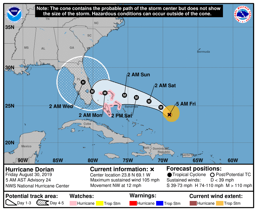
Dorian is then expected to begin to pivot back to the northwest and north. The exact timing of the turn to the north and how quickly that will occur is very much a question still. If that occurs just off the Florida coast, that has dramatically different impacts than if it happens on the coastline or inland over the Peninsula. We should get a few more answers on this later today and tomorrow. Dorian should then gradually work its way up the East Coast or just offshore, bringing heavy rain and potential tropical impacts to areas up into the Carolinas.
In terms of rain, totals will fluctuate as the exact track of Dorian becomes more clear. At this point, a widespread 6 to 10 inches is expected along the Florida and Georgia coasts, with higher amounts likely in spots. If Dorian slows, some areas could see as much as 15 to 20 inches of rainfall, depending on exactly where the turn occurs (less rain if the turn is offshore).
The bottom line on Dorian: It is likely to become a major hurricane and deliver major hurricane impacts to portions of the south and central Florida coasts, with heavy rain across much of the state.But there are still a few significant questions regarding exactly where Dorian turns that makes the forecast susceptible to some big changes later today or tomorrow. Eric and I will continue daily posts through the holiday weekend to keep you informed.
For us in Houston, the good news is that after the tropical wave moves ashore in Mexico and Dorian exits, the Gulf looks quiet through about September 10-12 or so, which is about as far out as we can realistically see at this point.
We are planning to vacation in Destin this Sat-Tues. In your opinion, is that a good idea? All the models seem to have the storm on the east coast of Florida.
I can’t really tell you if it’s a good or bad idea, but I can tell you that you should continue to monitor the storm and see what local officials in that area are suggesting. You’re probably fine if the current trends hold, but as we all know, things can change with hurricanes.
You mean things can change in a hurry-cane? Sorry. I’ll see myself out.
Is this a real question ^^ ?
LOL. I’m always amused the questions people ask Matt & Eric. Not only is the blog very informative for weather, but it makes for some good people watching. Oh, should I have pizza or ramen for dinner?
Be nice
To be fair, Destin is on the west end of the panhandle, and according to this morning’s NHC update they may not even get 1″ of rain from this storm: https://www.nhc.noaa.gov/refresh/graphics_at5+shtml/115127.shtml?rainqpf#contents
Hi Courtney! It is a real question. A dear friend of ours is battling cancer, and we are trying to take her on this trip before her next round of grueling treatments begin. Happy trolling!
Karen wins today. 🙂
Starbucks already started selling their Pumpkin Spice Latte with two new varieties! And a new pumpkin spice scone (but I don’t recommend the scone).
Thanks guys. I always look forward to your measured assessments of storm risks and enjoy your humor.
I really appreciate the graphics and visuals on your posts.
The leaves are starting to fall in the Houston area, not because autumn is here and it’s pumpkin latte time but because it is so hot and dry out there.
C’mon October!!
“As we begin -pumpkin spice latte- pray for a cold front season here”
LOL. #truth
Your information is really good and I thank you. If I am understanding Dorian as it is right now, can I assume that Orlando will be seeing heavy rain conditions as opposed to hurricane full force kind of stuff? My son just moved there this past week and he has never experienced a hurricane. We grew up in Michigan and when I experienced Harvey 2 years ago it was pretty intense. I just want to ease his mind as much as I can.
Rain is the biggest risk in that area, yes. If the storm does make it inland and make its turn to the north over the Peninsula or West Coast of FL, then Orlando could experience hurricane conditions, but it would likely be nothing like what they see along the coastline.
Thank you Matt!
We have had plenty of rain in San Leon but it is HOT! Love you guys and always check your site every morning!
How can I find out more info on the gulf disturbance that may be going into Mexico, we are leaving Galveston on a cruise going to Mexico in a week. Wondering how this will affect us.
I don’t think it’s going to impact you, but we will post about it here, and you can also check the National Weather Service offices in Brownsville or Corpus Christi or the National Hurricane Center for the latest.
Thanks for the updates on Hurricane Dorian. I’m a native Floridian with much family throughout the state. Your reporting is much more thorough than some of the local news outlets in Florida!
100 degrees vs. tropical shenanigans? Easy choice.
Just sending this out to the universe: Send a cold front please!!
Thanks for what yall do!
What is causing Dorian to move so slowly?