For parts of Houston, yesterday was a dry sandwich on rain.
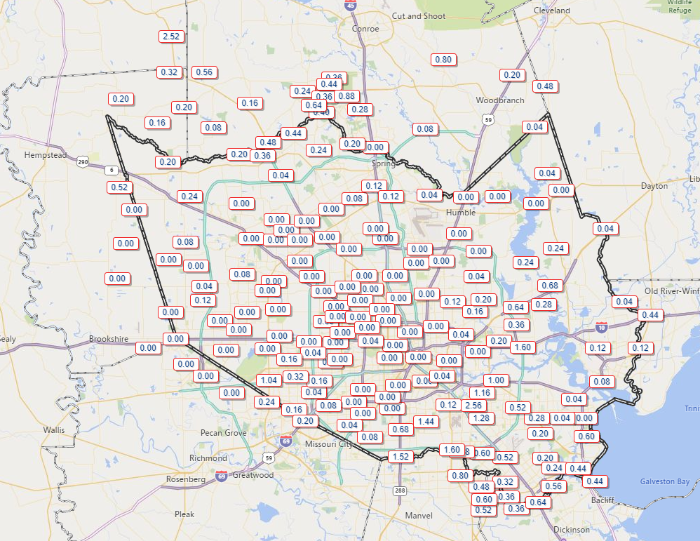
How’s that, Matt? Well, from the map above, you can see The Woodlands had just shy of an inch of rain in spots from morning storms. Grimes County even checked in with over 2.5 inches near Navasota. Other locations from northwest Harris into Montgomery Counties also got measurable rain. Then, south of Houston, afternoon storms deposited over 2 inches near Hobby Airport and over an inch down toward Pearland, with some more rain in other spots. Inside Houston, it was mostly dry. The east side saw some showers, but rains were mostly limited for the Inner Loop and north and west of town. We will take another swing at some rain chances today.
Today
Radar is quiet around the Houston area this morning, with just a few dying showers to our south.
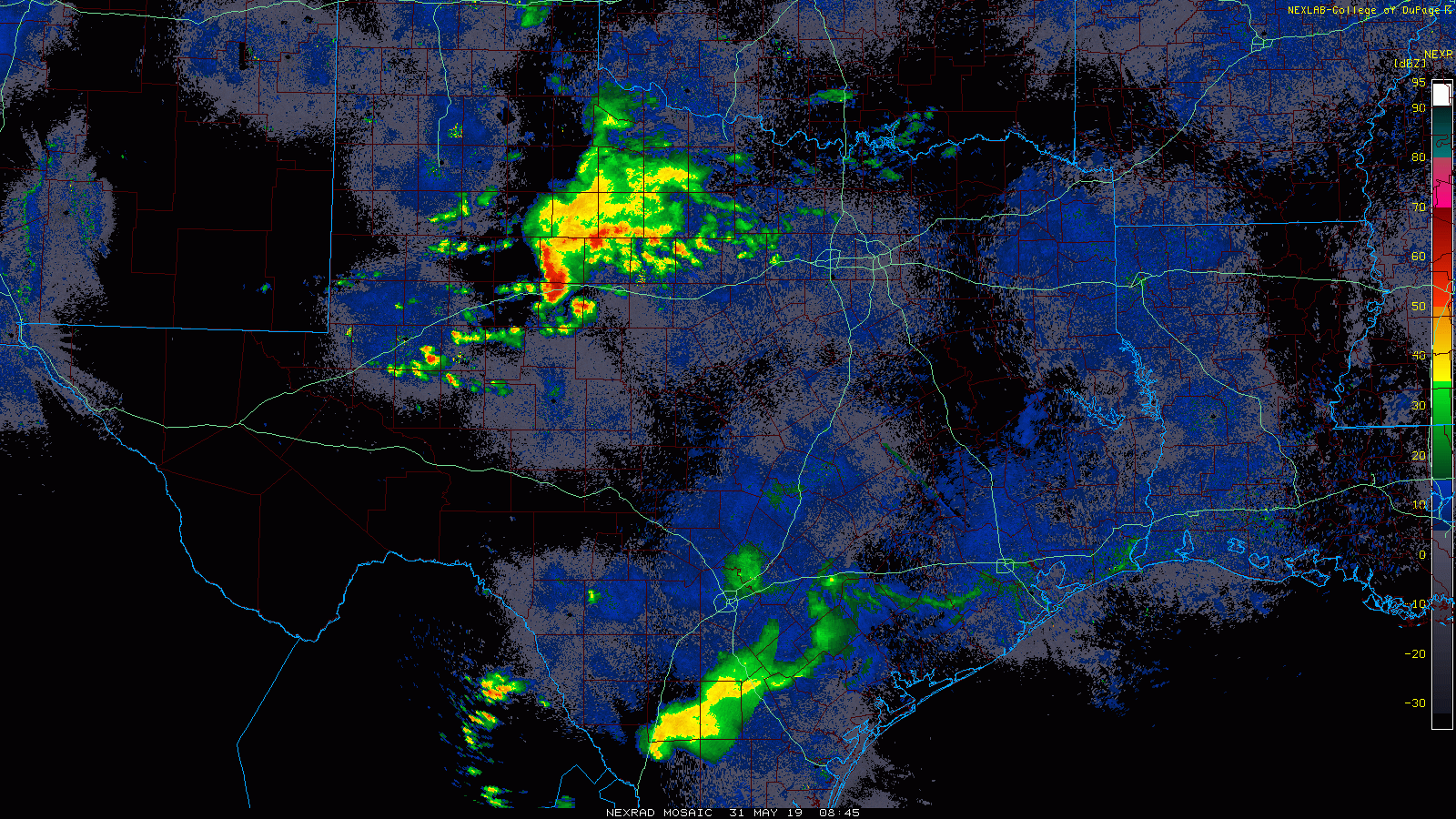
The more impressive storms this morning are near Abilene and west of Fort Worth. Look for that cluster of storms to drop southeast through the morning, possibly arriving far northwest of Houston near College Station by early afternoon. At the same time, a new scattering of storms should develop in and around Houston after 12-1 PM or so. So, the bottom line today: Expect a mostly quiet morning, with scattered storms this afternoon. Those under the most persistent storms later today could see two to three inches of rain in a short time. But also like yesterday, some folks in the area won’t see any rain at all. Have an umbrella for later, just to be safe.
Before and outside of any storms, temperatures will top off within a degree or two of 90 by early this afternoon.
Weekend
We shouldn’t see much more than a passing shower or two in the area for Saturday and Sunday. Most of us will be dry the entire weekend. Look for partly to mostly sunny skies both Saturday and Sunday. Temperatures will begin to heat up a notch further, with low 90s likely during the day away from the coast and upper-80s in Galveston. Nighttime lows will generally be in the lower of middle 70s inland and mid- to upper-70s along the coast or bays.

Next week
The week should start off similar to the weekend. Low- to mid-90s seem reasonable for highs in Houston on Monday, with low-90s Tuesday. We’ll continue with nighttime 70s across the area.
Things get more complicated beginning Wednesday and into next weekend. The weather pattern over Texas should shift a bit cooler and open the door to more rain chances again. I don’t want to speculate much on details this far out, but I would say scattered showers and thunderstorms should become more likely Wednesday and Thursday. While we won’t see any refreshing air masses, as we’re now firmly in a summer pattern here in Houston, we could see a couple days of “less hot” weather later next week.
“Dry sandwich”. I may be learning meteorological terminology slowly, but I’m not getting bored with it.
Hi Matt,
My family and I marveled at how pleasantly dry the air was the wind that made it even more pleasant up until about Wednesday. Though we had southeast winds roaring in from the Gulf, can you explain why the air was so dry? Dew points were in the low to mid 60s during the day last weekend, and even dipped into the 50s on Sunday!
You know, I’m honestly not sure. I noticed it was rather pleasant too. As you noted, we had mostly onshore winds during that time, so it wasn’t exactly offshore flow. My hunch is that we just fell under a strong enough area of high pressure that the air was able to dry out a good bit. The intensity of the high over the Southeast was close to record for the time period, so it may have just been enough to dry us out and not heat us up a ton. I wish I had a better explanation!
Huh! Interesting…I knew it was related to the strong high pressure over the Southeastern US and low pressure over the West, but yours is a good and trusted explanation. Thank you, as always!!
Can I order some rain on my lawn on rye, hold the mayo?
I know some areas got a plethora of rain a few weeks back, and nothing since. However, here in the old Katy area, we really didn’t get all that much then, and could REALLY use some now. Prefer a nice gentle soak late evening, or very early morning hours. If anyone here could arrange that, I’d be most grateful. HAHaHA! Have a great weekend folks, and thank you to Matt & Eric for the always great forecasting.
Please address the disturbance that the CMC model has going up the coast running through Houston..
Hi Arianda: We are probably going to post about it tomorrow. As of right now, we aren’t concerned about it tropically (read: We don’t expect a strong tropical storm or hurricane or anything to come of it). However, it could be a rainmaker for us later next week. Eric and I want to get a little more of a handle on this before we speculate on it (it sort of cropped up today as something to make us go, hmmm), so we’re purposely waiting til tomorrow to address it. But look for more on that soon. Nothing to lose sleep over right now though.