Houston wrapped up five very wet days on Saturday evening, as a weak cold front finally ushered an extremely moist air mass off to the east of the region, and stabilized the atmosphere. Before discussing out more sedate weather ahead, first let’s look back at the five-day rain totals, and whether the flood scale we implemented this month was effective.
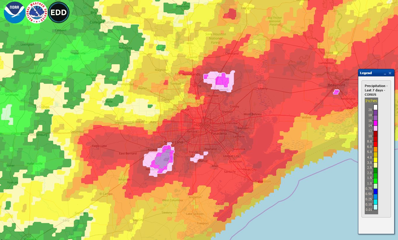
This map shows rain totals for the last seven days, and encapsulates the rain event that lasted from last Tuesday through Saturday. The greatest rain totals fell near Sugar Land, in the southwest part of the region, Kingwood, to the northeast, and Beaumont. One area near Sugar Land received 18+ inches, while the bright purple areas indicate 14+ inches. Overall, most of the Houston metro area received 6 to 12 inches of rain. Interestingly, one does not have to go all that far from the metro area to find a region, in this case Brenham, that received less than 2 inches of rain. This gives you some idea of the challenge of forecasting these kinds of precipitation events.
Flood scale
We introduced a flood scale to provide readers with a general expectation about upcoming flood events. Initially, we rated this five-day event as a “Stage 2 flood,” but after the intensity of Tuesday’s storms—which turned out to be the worst of the five days—we bumped these floods up to a Stage 3 event on Wednesday.

This feels about right in hindsight, given the five-day accumulations over some locations, but we’d welcome any comments or thoughts you have about the scale as we continue to refine it. Thursday night’s hail was also notable, and Matt may have some more to say about that the next day or two. Now, on to the forecast.
Monday
After last week’s storms, this week’s weather will be somewhat anti-climatic. Monday should be especially nice, with mostly sunny skies, highs in the low 80s, and for May, fairly dry air. Some clouds, along with southeast winds, return tonight with lows in the mid-60s. This would have been a great weekend day.

Tuesday and Wednesday
These will be a pair of partly sunny days with highs in the mid-80s. Despite the rather sedate appearance, there will be a fair amount going on in the atmosphere with warm fronts and small upper-level disturbances, and so we can’t rule out some scattered showers and thunderstorms popping up briefly. We do not expect any kind of training or seriously heavy rainfall, however, and accumulations should stay below one-quarter inch. Overnight lows will be in the upper 60s.
Thursday and Friday
We can’t entirely rule out rain chances for these days, but for the most part it looks like we’ll see highs in the mid- to upper-80s with partly to mostly sunny skies.
Saturday and Sunday
The weekend forecast is a bit trickier, unfortunately. Atmospheric moisture levels will be fairly high due to an onshore flow from the Gulf of Mexico, and the question is whether a capping inversion holds firm as a weak front moves in from the west.
Right now, it appears as though the best dynamics for storms will occur over central and northern Texas, rather than along the coast—but we’re still a long way from the weekend in terms of parsing details like this. For now we’ll go with partly sunny skies, highs in the upper-80s, and a 30 to 50 percent chance of rain both days, but be advised that the forecast is subject to change.
The flood scale worked for me. We got flooded by Harvey, and of course we experienced a lot of stress last week and through Saturday, but, as far as i can tell, it was what your scale predicted for our area.
Thank you, Eric. I especially appreciate your review and evaluation of your own forecasts after this significant weather event.
The flood scale worked for me too. Very understandable. Thank you!
Is there any reason why Clear Creek went to flood stage levels so fast compared with Harvey? To me it seemed like if we would have had some Harvey totals, Clear Creek would have been worse off now. Maybe I’m not remembering correctly.
Very much appreciate your fine work; as ALWAYS!
Was this a radar estimate of rain totals? Seems a little light vs. my rain gauge. The red colors that almost indiscernably blend together over my house seem to indicate 10-12″ when it was more like 13″ via rain gauge (about 3″ Tuesday night and 10″ from Thursday night to the last rain on Sunday morning).
The flood scale is a good idea although truthfully, it feels more like a post-storm classification system like the Fujita scale rather than a pre-storm prediction system. Tuesday was a good example of this since the initial rating was off and you had to readjust on the same day.
Underrating a storm could also give a false sense of security since, using Tuesday as an example, it turned out to be a lot worse than predicted.
To your above point, it is difficult to predict flooding events in Houston and even though most areas were flooded, some were considerably worse off than others. I would recommend simplfying the rating system down to three levels and have it classified as a pre-storm preparation system. Stage 1 can be used for adjusting schedules, stage 2 can be for major events that can require people to be ready to adjust their schedule on a whim (like leaving work early) and stage 3 can be for dangerous events where people preemptively take precautions like canceling school or work ahead of the storm.
Then use your current system as a post-storm classification system. That will simplify things and not require you to constantly adjust your ratings for minor changes in storm development.
I think it’s fair to say that technology is not quite there yet where you can accurately predict a storm to the nuance level that your 5 stage system requires. As a post storm system it is great though.
Just my two cents. Keep up the great work.
I second Samuel’s comments for the reasons he gives.
I like this idea!
Humans connect with a story. The danger of fearing a storm too much and repeatedly having it become less than the degree of preparations, makes people start to ignore the warnings. The flip side is an over-reaction (emotionally) or freak out that does not let a person prepare intelligently.
I think this form of classification does help give us the story of the unfolding weather situation. It connects the signs and models with a few points of reference from the past.
What would be missing from the three point pre- storm system is a sense of “what can I really expect” and this might keep the uncertainty too high. People would tune it out or look elsewhere for the magical answer.
But the point that the models keep changing and quickly shift as the weather unfolds, like the Tuesday upgrade, is important.
I do not think it would be too complicated if you could use both the predictive 5 stage model and also the 3 stage – what degree of surety are we in – – as two components of the modeling story.
5 stage would be the image of the program as it will likely unfold. And three points is the volume.
At any rate, our family is really grateful for the weather story as it it told here at Space City and for any weather event, I find myself sharing a link for the site with friends and neighbors and even strangers in the grocery line.
Thank you so much for sharing the site with others, Katherine.
I was wondering over the weekend if there would be a post-mortem. Thank you for publishing it, your hard work, and your honesty. We are all grateful.
I have subscribes for a while now and really appreciate the useful way you present your forecasts. Your presentations during storm event such as Harvey or the recent rains help us make decisions in a rational way without panic and over-reacting. Thanks and keep it up.
In the 1970s I was active in helping develop the wind and wave hindcast models for hurricanes that are used to develop design conditions for offshore oil and gas platforms. I recently ran across this quote I’d saved form those days, and thought you might find it amusing. It’s from Sir Napier Shaw’s Manual of Meteorology (1932). ” Every theory of the course of events in nature is necessarily based on some process of simplification of the phenomena and is to some extent therefore a fairy tale.”
As usual, excellent job! Thanks!
I think the scale worked well, provided users understood that it was meant to cover the entire Houston area.
I would recommend changing the wording of stage 3 from “hundreds of homes flooded” to “flooding in multiple parts of the city” or something like that. It seems like when many people read “hundreds of homes,” they reason, “what are the chances that my home is one of these hundreds of homes when the Houston area has hundreds of thousands of homes?”
Unfortunately, If you live in Houston, your home can flood. It just takes a few bags of trash getting caught up in the runoff and blocking the storm drain down your street. Area-based descriptions would communicate more clearly that the idea is the extent of the flooding, not the likeliness that any particular home will or won’t have water in it. As other commenters have mentioned, that would also be more clearly relevant to travel planning for everyone in the city, which is the biggest danger with these more-localized (i.e. non-Harvaic) events.
But again, I personally thought the scale was great. I didn’t freak out as much as I would have without it — the hundreds of homes that flooded in Kingwood were a few blocks away from mine, so any reassurance that this wasn’t actually the start of a watery Armaggedon was welcome. And on the opposite end of things, I interpreted the original stage 2 prediction as something I should prepare for, which I may not have otherwise.
Just my personal experience, I’m sure it differs from that of others’.
Thanks for your work! If either of you ran for mayor you’d probably have a good enough reputation by now to win!
I think the flood scale is good as it is, but tweaks will help. Jeffrey’s suggestion is a good one for example. I did not confuse this with a post mortem analysis. To me, it is an attempt to summarize the physical impact predicted by an ensemble of forecast models. It can be no better than its underlying forecast. So, you said 2, and in hindsight we got 3. Given the inherent unreliability of catastrophic event models, this is pretty good.
In terms of its utility, I can say this: on Wednesday, when my daughter reported that folks on Facebook were predicting Harvey-like flooding, I told her to relax—Space City Weather did not predict this type of event.
“This would have been a great weekend day.” What Monday wouldn’t be though? LOL Thanks for everything you do!!
I think you were right with your initial forecast of stage 2. I’m also not clear how such a forecast benefits anyone, because you never know which isolated parts of the area will flood; all you’ll do is get the usual suspects excited and scared (e.g. Meyerland) when in fact there is probably no threat to them. Instead, just say that there will be isolated areas of heavy rain that will cause localized flooding, but we don’t know exactly what these isolated areas are.