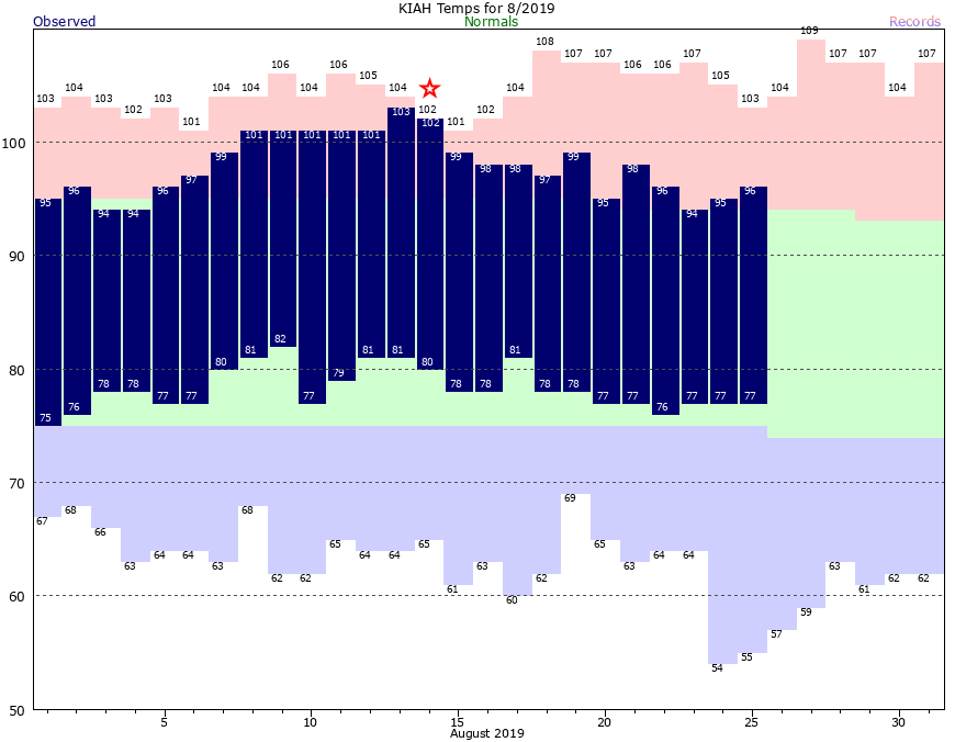
As often is the case, August has been a lousy month for weather in Houston. Certainly, the region did not experience a devastating hurricane this month (ala Harvey), or a massive heat wave (ala August, 2011). However, the average temperature this month has been 88.0 degrees, which is about 3 degrees above normal, and we did have a week straight of 100-degree or warmer days earlier. We won’t be quite that hot during the last week of the month, but we’ll still be plenty warm.
Monday and Tuesday
After a wet Sunday for much of the Houston, pressures are rising and that should bring rain showers to an end for a few days. Skies will be mostly sunny, with highs in the mid- to upper-90s for the region. Lows again will be sultry, falling to only 80 degrees for most of Houston. Any showers that develop should be near the coast, isolated, and briefly lived.
Wednesday and Thursday
A weak front appears likely to stall over north Texas in the middle of the week, and some of the instability related to this could generate some scattered showers across the Houston region. We’re still looking at partly sunny, and warm days with highs in the mid- to upper-90s, however. I’d peg rain chances at about 30 percent both days, with accumulations generally measured in tenths of an inch.

Labor Day weekend
Overall, the upcoming Labor Day weekend looks mostly sunny and dry for the Houston metro area. A front with slightly more oomph could push all the way through Houston by Friday or Saturday. As is common with August “fronts,” these typically bring some drier air but not much in the way of cooling. As a result, daytime highs this weekend will probably reach the mid-90s, with mostly sunny skies. Lows might fall about 5 degrees below where we’ve been, and any drier air would feel quite lovely after this summer. But it remains to be seen how much drier air works its way into Houston.
Tropics
As we get into late August, the tropics have begun to characteristically heat up. However, there remain no imminent threats to the Gulf of Mexico. Tropical Storm Dorian formed over the weekend, but it appears bound for Hispaniola, where wind shear and mountainous terrain will most likely weaken the storm considerably.
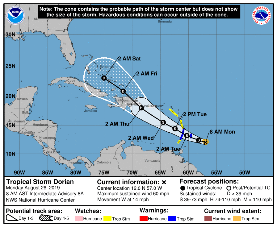
By this weekend something may spin up in the northeastern or central Gulf of Mexico, but the odds are low that this becomes anything more than a depression. We’ll keep watching, of course.
Glad Dorian is of no concern for us in the Gulf but curious about the impacts on the Bahamas this weekend as we are set to cruise there…?
I’ve had 4″ of rain the past week, so I think we can turn off the thunderstorms for now.
And yes, I did get rained on in Minute Maid Park yesterday – third time this year.
We’ve barely got any up here on the NW side, so I’d like very much if the rain didn’t go away.
Run a 2” pipeline to my house and you can have the rest. Environmental permitting should only take about 20 years or so.
Thanks guys. We officially received 2.07 inches Saturday night into early Sunday morning. While we could use more of the liquid gold…this moisture definitely received the welcome mat. Wish you had some more good news for the week. I’m not giving up total hope on the “Barryesque” system but as you guys have pointed out…probably not going to happen.
Eric, one of these days, your only post should state: Houston, its August, it’s hot. Get over it. Talk to you in September
The heat index is high today. Will tomorrow be better for outside work?
I’m supposed to attend a wedding in Jamaica this weekend, any thoughts on potential impacts?
Eric, August rain total in Fulshear so far has been only 0.17 inches. How can this be? Any scientific explanation?
The scientific explanation is it didn’t rain there very much.
Count our blessings: at least most of us around Houston have seem some measurable rainfall over the last couple weeks, with no flooding. We did get a nice bite-sized taste of fall near the end of July/early August, when the temps and humidity dropped for a couple of fantastic days. And now, we’ve finally reached the point where we’re talking about “cool” fronts moving into the area, which should start to happen now with a little more frequency. All in all, I’ll take it!