Summer continues apace this week—for the love of God, is August over yet??—with not much overall change in the forecast. We can expect highs in the upper 90s and lows around 80. Some drier air this weekend may help with nighttime temperatures, but we’re making no promises. We’ll also discuss the tropics in today’s post because it’s that time of year, and the Gulf may see some activity over the next week or so.
Tuesday
We’ll start today with mostly sunny skies, and highs are going to pretty quickly leap up into the mid- or upper-90s. However, it appears as though the sea breeze may be a little more active this afternoon than Monday, with scattered thunderstorms popping in the 2pm-6pm range this afternoon.
Wednesday and Thursday
These should be typical summertime days in Houston, with highs in the upper-90s, and afternoon shower and thunderstorm chances in the 30 percent range. Nights remain warm and sultry and unpleasant.

Labor Day Weekend
If you have outdoor plans, I hope you have included some water in those plans. Yes, a very weak front will approach the region and may reach Houston this weekend. But no, it’s not going to bring much cooling. If you’re far enough west or north of Houston, you may possibly see some dewpoints in the lower 60s or upper 50s on Sunday and Monday, but right now we don’t think this will be all that noticeable in Houston.
For the most part, we’re going to see highs in the upper 90s, mostly sunny skies, and rain chances of 10 to 20 percent each day.

Tropics
We are now in the heart of the tropics season, and the Atlantic has started to wake up with a tropical depression (which we can ignore) and Tropical Storm Dorian, which has the potential to become a hurricane over the next five days. Finally, some forecast models show a slow development of thunderstorms over the central or southern Gulf of Mexico in about a week, that could congeal into something tropical, or not. To be clear: We have no imminent concerns for Texas whatsoever, but at this time of year we watch everything. Let’s talk about Dorian for now. Here’s the National Hurricane Center forecast track on Dorian:
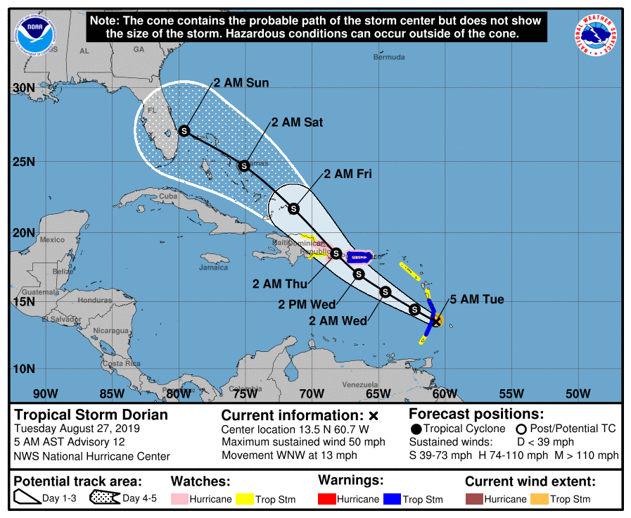
There are lots of questions about Dorian. How will it handle interaction with Hispaniola in a couple of days time? How will it handle dry air in the coming days? Near the Bahamas, it will have the potential to strengthen, but how much? As a best guess, it will probably be a strong tropical storm or a hurricane when it nears Florida by Saturday or Sunday. Then, what happens after that? Here are the ensemble forecasts from the European model:
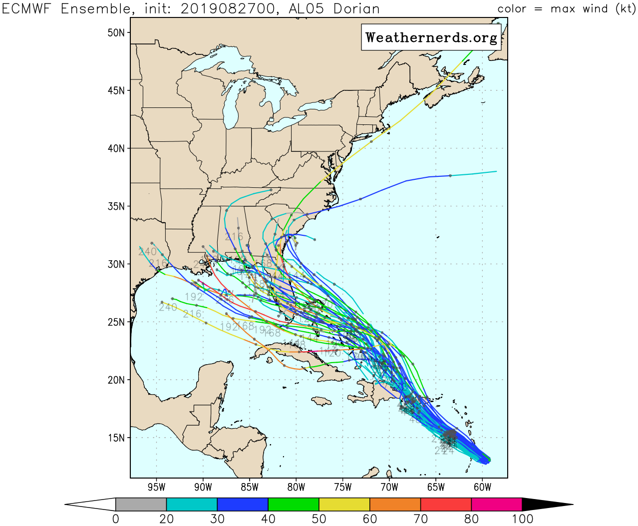
The ensembles have shifted somewhat west since Monday morning, meaning that there is now a chance Dorian crosses the Florida peninsula and comes into the Gulf of Mexico before making a northward turn. Should Texas be concerned about this? We don’t have answers to many of these questions, but on this latter one, we can say that right now there really is no reason for Texas to be concerned. However, the forecast is far enough out for any Gulf impacts—about a week—that things can obviously change with the forecast.
If Texas i impacted can we blame Pete Olson?
That was something else.
I don’t get it…
Great site, guys. I anxiously await news of the first cold front this fall 🙂
I anxiously await writing about the first fall cold front, too. Alas … crickets.
Yeah, the last few years September (and even sometimes October) have been disappointing in terms of cooler, dryer air. Of course last year we seemed to jump right from hot and humid into cold and wet… I know.. I know.. if I didn’t have the weather to complain about..LOL…
Not crickets. Cicadas.
Hmm…. supposed to be flying into Orlando on Sunday afternoon. 🤔
Not a great time, but still a long ways to go in terms of what will happen with Dorian.
Thanks guys. Looks like tiny Dorian is not going to give up without a fight
A few days ago Channel 11 said Dorian would fade away after hitting the mountains on Hispaniola.
Then the track shifter north and they quietly forgot that forecast.
ANY weather forecasters who fail to end with, “but, it’s too early to be certain”, are not worth your time for more than temperature readings, IMO. That’s what sets Eric & Matt apart.
Why would they keep mentioning a forecast that was no longer viable?
They never explain that things have changed. Or why they changed.
The reason is self evident. The forecasts track changed and the previous forecast is no longer relevant.
My point is that this should be explained, that there was a change.
Let’s just hope we don’t end up with…. The Picture of Dorian Gray.
I’ll just let myself out…