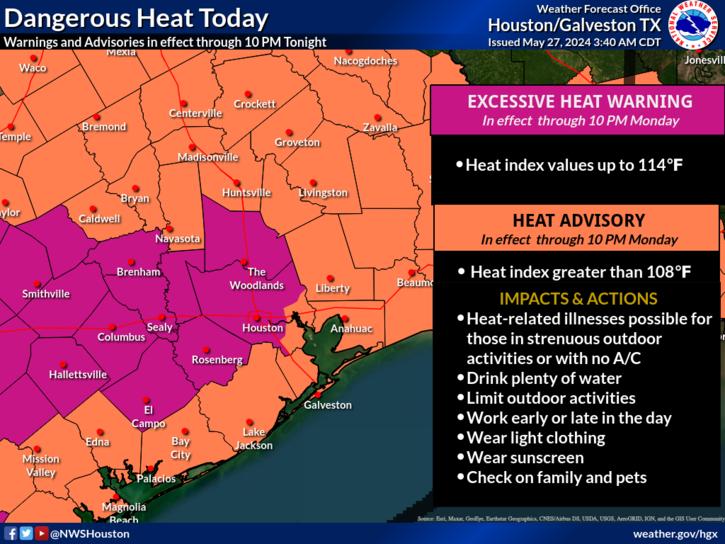
In brief: Just a short update this morning due to the Memorial Day holiday, but it’s warranted due to the extreme heat over inland parts of the metro area. After today we’ll see somewhat cooler weather and a return of some modest rain chances later this week.
Monday
Today will be sunny and hot, with much of the area seeing high temperatures in the mid- to upper-90s. This will be the region’s hottest weather since late September of last year, and it will feel sweltering outside. Please take heat precautions if you are outdoors from the late morning to late afternoon hours. There is a slight chance of showers, and possibly a few thunderstorms, during the overnight hours as a boundary slides toward the Houston region. However the most likely scenario is that a capping inversion remains solidly in place, preventing the development of any storms. Lows tonight will be around 80 degrees.
Today will be very warm across the Houston metro area. (National Weather Service)
Tuesday
A partly to mostly sunny day with highs in the low-90s. Tuesday evening into Wednesday morning will see another chance for some storms, but once again they’ll be battling against a capping inversion. I’d peg the chance of showers and thunderstorms Tuesday night at about 20 percent, but we’ll need to fine tune this in tomorrow’s forecast.
Wednesday, Thursday, and Friday
These will be partly sunny days with highs in the upper 80s to 90 degrees. Each of these days will see a decent chance of rain, perhaps on the order of 40 percent or so, in the absence of high pressure. However, I don’t have a great handle on the details or the timing. Showers will be most likely along and north of Interstate 10, where accumulations of 1 inch or more are possible.
Saturday and Sunday
Rain chances will linger into the weekend, with highs likely in the upper 80s to 90 degrees. At this point both days should see at least partly sunny skies, with Sunday having the greater chance of being mostly rain free.
In brief: After a few mostly cloudy days we’ll see increasingly clear skies and this will help temperatures march upwards. We’ll go from highs in the low-90s today, to mid-90s this weekend to upper-90s by Memorial Day. After that a weak front will provide some modest relief.
Thursday
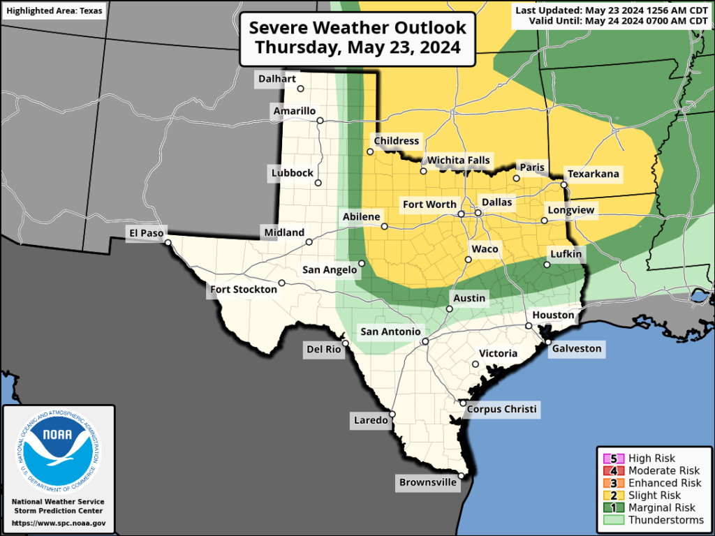
After a cloudy start we should see partly sunny skies this afternoon, and this should help to push high temperatures into the low-90s. Winds will blow from the south at 10 to 15 mph, with occasionally higher gusts. Once again, we should see some fairly strong storms develop in central Texas to the north of Austin. While these will propagate eastward, I expect them to remain north of Highway 105 once again, with no impact on the greater Houston metro area. Low temperatures tonight will only drop into the upper 70s.
Some severe storms will be possible, once again, far to the north of Houston later today. (NOAA)
Friday
A day very similar to Thursday, although high temperatures are likely to be a degree or two higher.
Saturday and Sunday
We’ll see mostly sunny skies this weekend, with high temperatures solidly in the mid-90s. We will be hitting our first highs above 95 degrees nearly three weeks earlier than normal, in case you were wondering whether this is typical weather for late May. It’s not. Nighttime lows remain sultry, around 80 degrees.
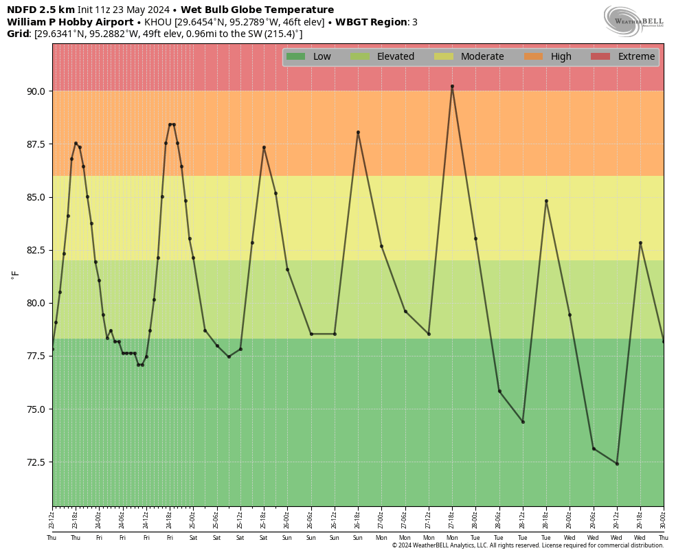
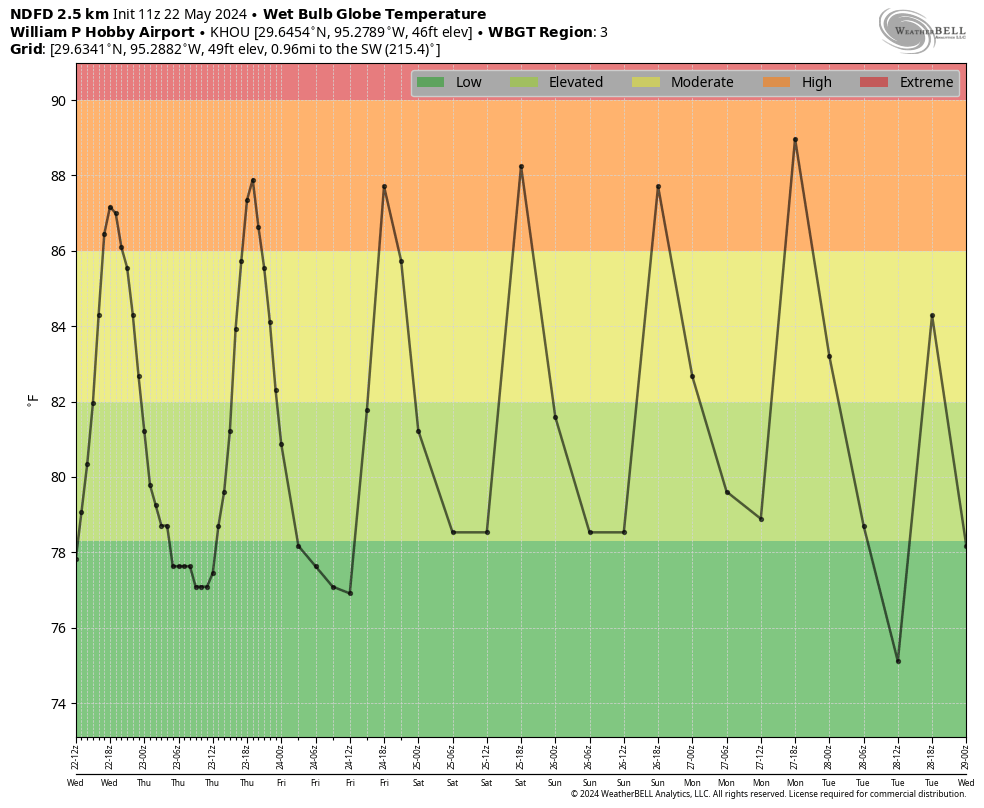
Wet bulb globe temperatures for this week. (Weather Bell)
Memorial Day
Everything comes together on Monday, sunny skies and the characteristic jump in temperatures associated with an approaching front, to push our highs into the upper 90s. If we look at wet bulb globe temperatures—a measure of heat stress in direct sunlight that takes into account air temperature, humidity, wind speed, sun angle, and cloud cover—we see the potential for an ‘extreme’ day in terms of heat. Please bear this in mind if you have outdoor activities planned.
Tuesday and beyond
We’ll see a slight chance of rain on Monday evening as the front approaches and moves through, but for now I don’t expect anything more than a dusting of showers. Highs next week look more reasonable, in the low 90s, with overnight lows perhaps in the mid-70s. We’ll also see some daily rain chances in the Wednesday through Saturday period, although they may be of the 20 percent daily variety. I’m not sure yet. In any case, the very end of May should see a bit of a return to normalcy.
In brief: A dying front brings a chance of storms well to the north of Houston tonight, but for most of us the story remains one of heat. Temperatures will peak over the weekend, with Memorial Day looking especially hot.
Wednesday
Expect another warm day in Houston, with highs of around 90 degrees due to mostly cloudy skies. It will be a little windier than Tuesday, with southeasterly gusts up to about 20 mph. With the humidity, it will feel plenty hot outside during the daytime hours before lows drop to about 80 degrees tonight.
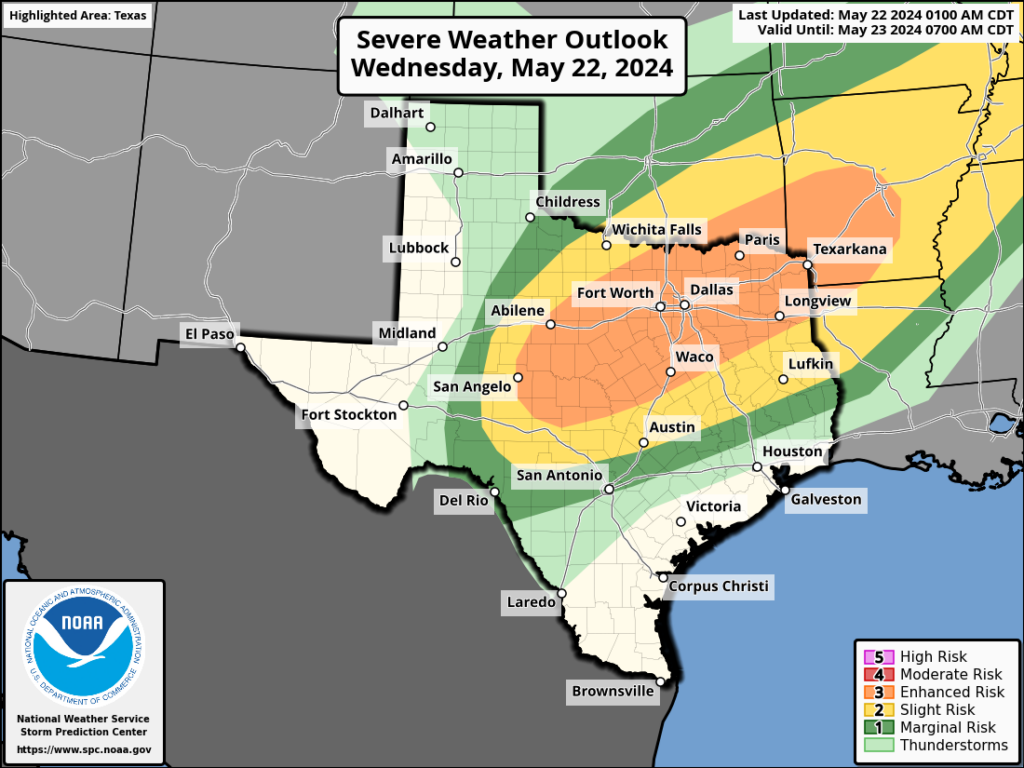
There is a healthy chance of storms well to the north of Houston later today and tonight. (NOAA)
For areas north of Houston, and by this we are probably talking about locations north of Highway 105 in Montgomery County, there is a chance of storms later this evening and during the overnight hours as a dying frontal boundary pushes a line of storms through northern Texas. There is some question as to how far south these storms will get. It is possible that locations such as College Station and Huntsville could see some thunderstorms tonight. There is even a slight chance that locations further south, including The Woodlands, could see some of this action. However, I think a capping inversion will probably prevent such activity for most of the Houston metro area, including at least the southern half of Montgomery County.
Other than this, we should be rain-free through the weekend.
Thursday
Expect partly sunny skies and a high of about 90 degrees with plenty of humidity. Another warm night.
Friday
As skies turn mostly sunny, expect highs to nudge up into the low 90s with plenty of humidity.
Saturday, Sunday, and Monday
The holiday weekend looks hot and sultry. Highs will rise from the low 90s on Saturday to the mid- to upper-90s by Memorial Day with mostly sunny skies. Folks, it’s going to be Houston hot this weekend, so take all appropriate heat precautions. That includes sunscreen during the daytime with the Sun reaching an angle of 80 degrees during the early afternoon hours.
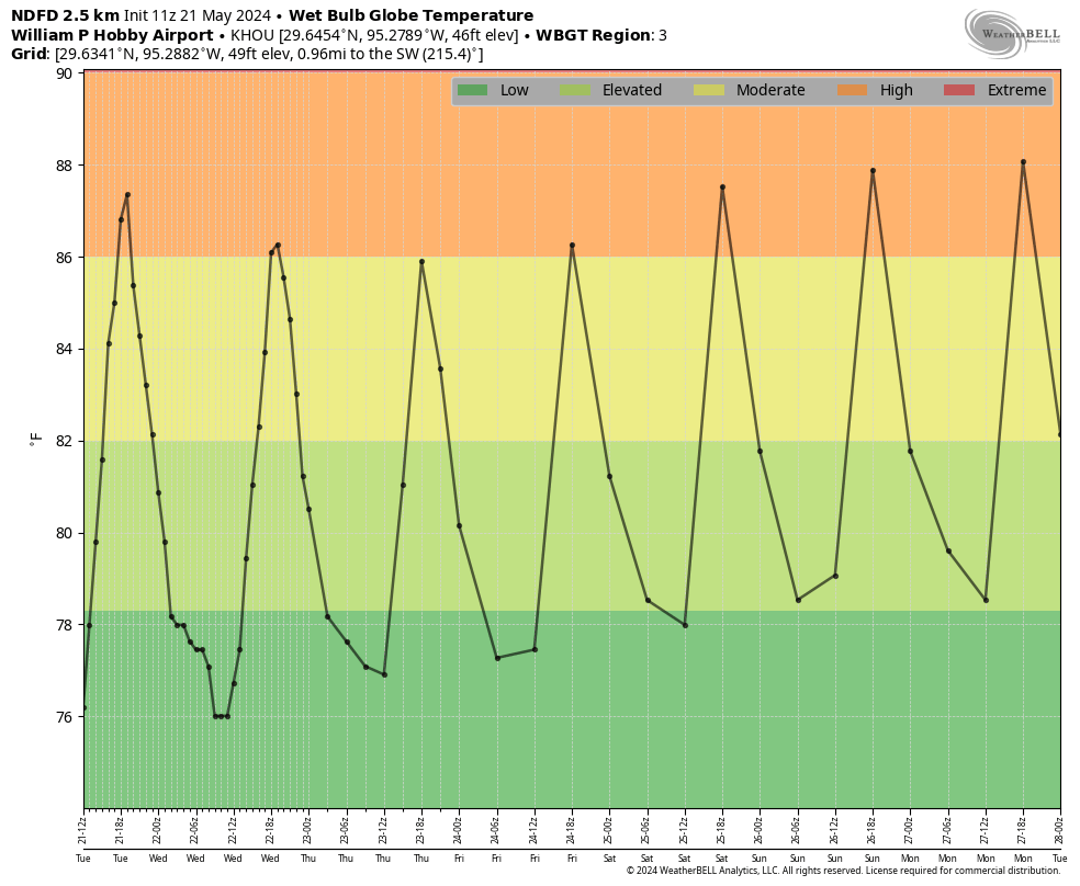
Wet Bulb Globe Temperature forecasts give a sense of the heat to expect this weekend. (Weather Bell)
Next week
So what happens after Memorial Day? It still looks like some sort of weak front arrives on Monday night or Tuesday. It’s late May, so your expectations should be for slightly cooler weather, and slightly drier air, and not much more. Still, beggars cannot be choosers at this time of year. Rain chances look a little bit improved later next week, but we’ll have to see about that. I don’t have much confidence in such a prediction.
Last week’s storms
Check back later this morning as Matt has a post on last week’s storms, and where they share some commonality with Houston’s history of similar events. It’s a great article with a lot of historical context.
In brief: Today’s post talks about the arrival of summer-like weather in Houston, and breaks down the four phases of summer. We also discuss a new offering from the National Weather Service called “HeatRisk.” Finally, we look ahead to a hot and sunny Memorial Day Weekend.
We’re starting to see 90-degree days on the regular which, in my mind, signals the start of summer in Houston. Long-time readers will know that I like to break summer down into four phases. Why? Because “summer” season lasts so long, nearly five months. This is contrast to meteorological summer, which runs from June through August, and “solstice” summer, which runs from June 20 through September 22 this year. For me, Houston’s summer typically runs from about mid-May through mid-October. Here are the four phases:
Early summer: When we first start to see 90-degree temperatures with regularity, but some nights in the 60s are still possible, and there’s still the thinnest hope of a weak front
Mid summer: When highs run from 90 to 95 degrees, and nights are sultry, but you know it could still get worse
High summer: Somewhere between late July and early September there’s a period where temperatures reach the upper 90s to mid-100s and you realize, “Ok, this really is the worst.”
Late summer: This is the period in September and early October when days grow shorter and we usually see the first front or two of the season. But most of the time it’s still hot.
Early summer began this week in Houston, and we have a chance to bump into Mid summer early next week before we drop back into early summer. You may think it’s crazy to have gradations of heat during summer, as Houston is invariably hot and humid during the summer months. But as we found out last year, there is heat and there is heat. Last summer we used the “wet bulb globe temperature”to measure how hot it really felt outside, and we’ll continue to use this tool. However there’s now another way to assess the heat.
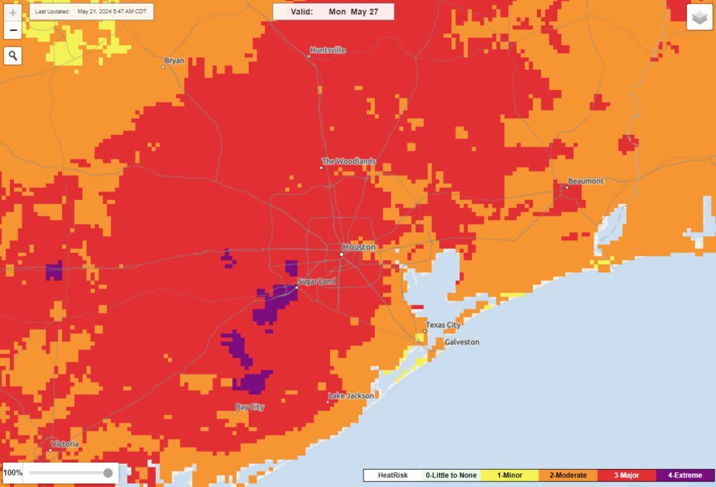
HeatRisk map for Monday, Memorial Day. (National Weather Service)
This year the National Weather Service is introducing a “HeatRisk” color-based scale that takes into account the following factors to provide guidance for outdoor activities:
How unusual the heat is for the time of the year
The duration of the heat, including both daytime and nighttime temperatures
If those temperatures pose an elevated risk of heat-related impacts
The scale ranges from green (little or no risk) to magenta (extreme). If we look at the risk for Memorial Day we can already see a few areas of Houston reaching an ‘extreme’ level of risk. This is due to temperatures likely in the mid- to upper-90s and the time of year, late May, as we’ve not re-accustomed ourselves to the heat yet.
We’ll see a few more clouds today than we saw on Monday, and this should help hold temperatures to about 90 degrees. Winds will be from the south, at 10 mph or so, with gusts up to 20 mph. Aside from that it’s going to be another humid day, with a warm night in the mid- to upper-70s.
Wednesday
Skies should be partly to mostly cloudy on Wednesday, and this should allow some parts of Houston to stay in the upper 80s. However, if we get a bit of sunshine during the afternoon hours, highs in the low 90s are possible. Still warm. Still humid.
Thursday and Friday
These days will probably bring mostly sunny skies, so temperatures from 90 to the low 90s are likely. Nights remain warm.
Wet Bulb Globe Temperatures will be high this week, but not extreme. (Weather Bell)
Saturday, Sunday, and Monday
Hot and mostly sunny. Highs this weekend are likely to reach the mid-90s, with upper-90s possible on Memorial Day. By Monday it looks like a weak front will approach the area, bringing a chance of rain with it. However I don’t believe this front will arrive in time to modify conditions during the daytime on Monday.
Next week
The front should arrive on Monday night or Tuesday, and at this point it does appear as though the boundary will indeed push all the way to the coast. Don’t expect miracles in late May, but we might see some slightly drier air and highs in the upper 80s, with modestly cooler nights. It isn’t much, but it’s the best we can reasonably hope for at least the next three months, and probably longer.