Summary: After a stormy weekend Houston’s weather takes a turn to the sunny side of things. In fact, we should see rather mild weather for the rest of the month, with only some very sporadic rain chances.
That brief period of Goldilocks weather
It’s March 18. The Houston Livestock Show and Rodeo is over. After living here for decades, my sense is that prior to the rodeo we are still capable of seeing cold, winter-like weather. Then, after the three-week show wraps up, our chances of really cold weather are pretty much over and we’re deep into spring. And that’s certainly the case this year.
Although temperatures tonight are likely to drop into the upper 40s in Houston, the remainder of the month looks fairly mild, with lows generally in the 50s and low 60s, and highs in the 70s. This is the ephemeral period of Houston weather in which we can enjoy a balance between the extremes, the Goldilocks weather that’s not too hot, and not too cold.
Monday
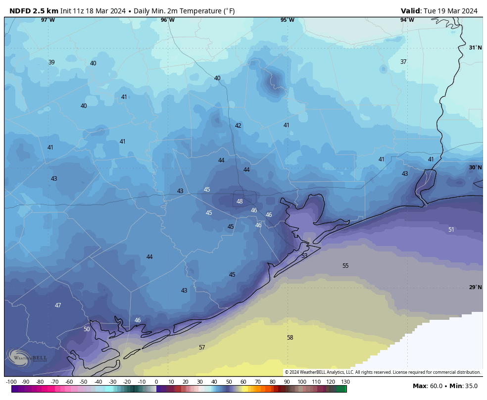
After an at-times turbulent weekend with passing showers and storms, drier air associated with a cool front is finally moving into Houston this morning. We’ll see breezy conditions this afternoon, with gusts up to 25 or 30 mph from the north, as this drier air arrives. Skies, otherwise, will be partly sunny with temperatures in the upper 60s. Tonight will be the chilliest night of the week, as winds slacken and skies clear. Look for Houston to drop into the 40s, albeit precisely where in the 40s will depend on your location.
Tuesday
This will be a banger of a spring-time day, with mostly sunny skies, light winds, dry air, and highs in the mid- to upper-60s. Lows on Tuesday night will drop into the mid-50s as a light southerly flow reestablishes itself.
Wednesday
We’ll be a bit warmer, and a bit more humid on Wednesday as the onshore flow continues. Look for highs of around 70 degrees, with partly sunny skies, and light southeasterly winds. Lows on Wednesday night will drop to around 60 degrees.
Thursday
Somewhat more dynamic weather is possible on Thursday as a coastal low pressure system approaches. This will bring a chunky chance of rain into the area, but the finer details remain elusive. The question is whether the bulk of the precipitation remains offshore, or not. For now I’ll say that if you live inland of Interstate 10, there’s maybe a 40 percent chance of rain, and that becomes increasingly higher as one gets closer to the coast. This is the kind of system that probably will bring 0.25 to 1 inch of rain to most, but again we’re painting with a broad brush here. Highs, otherwise, should be in the low 70s with mostly cloudy skies.
Friday
As the low moves off we should see sunny and mild conditions, with highs in the 70s.
Saturday and Sunday
The weekend looks mild, with partly to mostly sunny skies, and highs in the upper 70s to possibly 80 degrees. Nights will be mild, in the upper 50s to lower 60s. Rain chances, at this point, look low to non-existent. It looks like good bike riding weather to me.
Next week
By around Monday or Tuesday of next week the region’s next front should arrive. It may (or may not) bring some rain showers with it. This should carry our mild, spring-like weather through the end of the month, which likely means more highs in the 70s and lows in the 50s.

Here in Friendswood we recieved less than 1/2″ rain total over the last several days. The ground still is dry and cracking from a lack of rain over the last month or so. With the end of El Niño and a La Niña likely this summer I am worried about back to back summers with excessive heat and drought. It sucks hoping something tropical comes in from the Gulf in August to relieve drought because you have to be careful what you wish for…
Only 0.75” here in LC near NWS site. Drought coming for us if we don’t get inches and inches of rain soon.
Glenn my dear fellow. It would be a 3peat.
2022 was a foundry around here.
We’ll find out where the summer ridges set up this summer. It’s the key to whether we get high temperatures in low 90s with regular afternoon thunderstorms, or Sahara west for the 3rd summer in a row.
If we can keep up with a rainy spring and decent ground moisture maybe????? That might be averted.
Hooray for drier air and our Goldilocks weather for the rest of the month.
The NOAA forecast had predicted that we would get 2” of rain in Spring this past weekend. Instead, we got .15”. What happened that the forecast was so wrong for our area?!
Many parts of town did get much more rain, we got about 1.4 inches where I am in the Heights. The Houston area is huge so there’s always gonna be less & or more depending on location.
Accuweather was saying that the Houston area could receive an entire month’s worth of rain last weekend. The average total rainfall was if I remember correctly forecast by WPC to be a bit more than 2 inches. The actual average was probably about 1 inch. The forecast for Saturday and Saturday night was a total bust. I really want to know what happened. Is the forecast for the storm on Thursday likely to be as bad? WPC is currently forecasting more than an inch of rain for my area; is that at all reliable, or should I expect less than a quarter inch?
Even though every March in the past 5 years or so has been abnormally dry, we are nevertheless on track to have one of the driest Marches I can remember, and this is supposed to be El Nino.
In fact, all 5 observation stations in the Houston-Galveston area observed about 0.4 inches of rain, suggesting that the average was probably less than I mentioned above.
sorry, a correction: the Galveston station may have not recorded the rainfall from Saturday night.
There were some outliers but the forecast seemed spot-on for most of the metro, including my area (West U). Got roughly 2.5″ per my rain gauge – everything is nice and lush now!
Agreed 😊
I’ll definitely take this goldilocks weather
🌬 ⚘⚘⚘
This march has had so many clouds yet very little rain.
We got hammered in southern Fort Bend and northern Wharton counties. 3 to 4 inches across my farms and pastures. Baseball hail that damaged 6 vehicles and 2 tractors. Holes through barn roofs. Lots of trees down. Very intense storms.
Montrose got a good soaking as well this weekend, so I’m thankful for that. Glad to have a break from it this week!
I had pea size hail in Sweeny with the storms yesterday. Luckily it did not do any damage to my truck. They had it much worse in Angleton on Friday evening. A tornado rolled through the north side of Angleton and caused significant damage to multiple businesses. They also had golf ball size hail.
That’s nice, but what I really need is rain. Only 0.2″ this weekend.
Yeah. We only received.36 over three days ending yesterday. The drought pattern continues to sizzle. We need a good two day soaking. A nice line of storms from conroe to Corpus four hours
ha, the commentary on temperatures based on rodeo season is absolutely my observation as well.
before the cookoff I don’t even think about planting my summer vegie garden, on cookoff weekend I look at the forecast and if there’s nothing cold coming I plant outside, it’s never failed me yet.
waiting for the pecan trees to leaf as a gauge for the final freeze would put me way behind the 8ball with food on the table!