Summary: The weekend continues to look fairly wet, with early Sunday morning the time at which we’re most likely to see heavy rainfall and organized storms.
As expected, storms on Friday brought some heavy rainfall and hail into the greater Houston region. The worst of this occurred in southern Fort Bend County, near Needville. Hail as large as 2.75 inches in diameter, which is very nearly the size of a baseball, was reported there and caused significant damage to structures. Fortunately, the conditions for severe weather are less favorable moving forward into today and Sunday.
So what should you anticipate? The radar is quiet this morning, and should remain so into the early afternoon hours. It is possible that a storm system to our southwest will move into Houston late this afternoon or early evening. However I think the most likely outcome is that it veers south of our area, or weakens substantially. Probably, then, we’ll see scattered, light to moderate showers this afternoon and evening. But there is a slight chance of some stronger thunderstorms we cannot entirely dismiss.
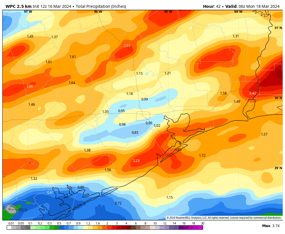
The forecast for tonight and Sunday morning is a little more interesting. It appears as though a fairly strong atmospheric disturbance will approach from the west and produce a line of showers and thunderstorms tonight. In terms of timing, I’d anticipate these storms arriving on our western doorstep between 3 am and 6 am, and then pushing through Houston around sunrise and off the coast shortly afterward. Accumulations will vary widely, but I expect 1 to 3 inches of rain will be possible.
For the rest of Sunday, we can anticipate on and off showers throughout the day, with cloudy skies and the mid-70s. I’m afraid the chance of rain will not entirely go away until drier air starts arriving behind a front on Sunday night.
The bottom line is that this weekend looks fairly wet, but perhaps not disastrously so. Please remain weather aware as you venture out and about. We’ll update further this weekend, if necessary.

Still waiting on anything beyond drizzle. So far a bust in terms of rain.
Maybe for you, it flooded where I was downtown.
Friday evening storms? What Friday evening storms? The Clear Lake area (Northfork for me) received NO rain on Friday and a tiny dusting (.05″) overnight. That was also true of the showers a few weeks back. Drought time here……
There were friday evening storms even if your area did not receive rain. Not sure why you have an issue with the wording in todays post?
Glad we didn’t get the severe stuff but in 77095 we only got .2″ rain. You could see the storms dissolve as they approached our area. The golf course ponds are down about 2′ again after getting to full pool during the last rain event.
We got just enough rain in 77019 Montrose last night. The plants are happy.
Angleton was also hit hard with golf ball size hail and 80mph winds. Multiple business took alot of damage.
Montrose poured last night. I’m thankful I was home and didn’t lose power! Here’s hoping the Sunday drive into work at 5am is doable. Thanks!
On Thur afternoon, anticipating the rains, I mowed about 4 acres out here in Magnolia, but ran low on gas. It rained maybe an hour Thur night.
.
Noontime on Fri went to grocery, then got gas for zero turn. Finished mowing the rest of our acreage about 3pm – just in time.
About an hour later, rain fell for an hour or so, then drizzled a bit.
.
Then, about 2am Sat morn, it rained for maybe an hour (via security cams). Supposed to rain (future radar) here about 2pm, then again starts about 8pm for xxx hours.
.
Good to have the rain, but now it looks like I’m back to mowing acreage every 7-10 days again 🙂
Almost 8PM. Still nuttin’.
Saturday night 11:00pm. I don’t have my big storm coming headache or dizziness. I’m hoping I’m right. I hate night time storms.