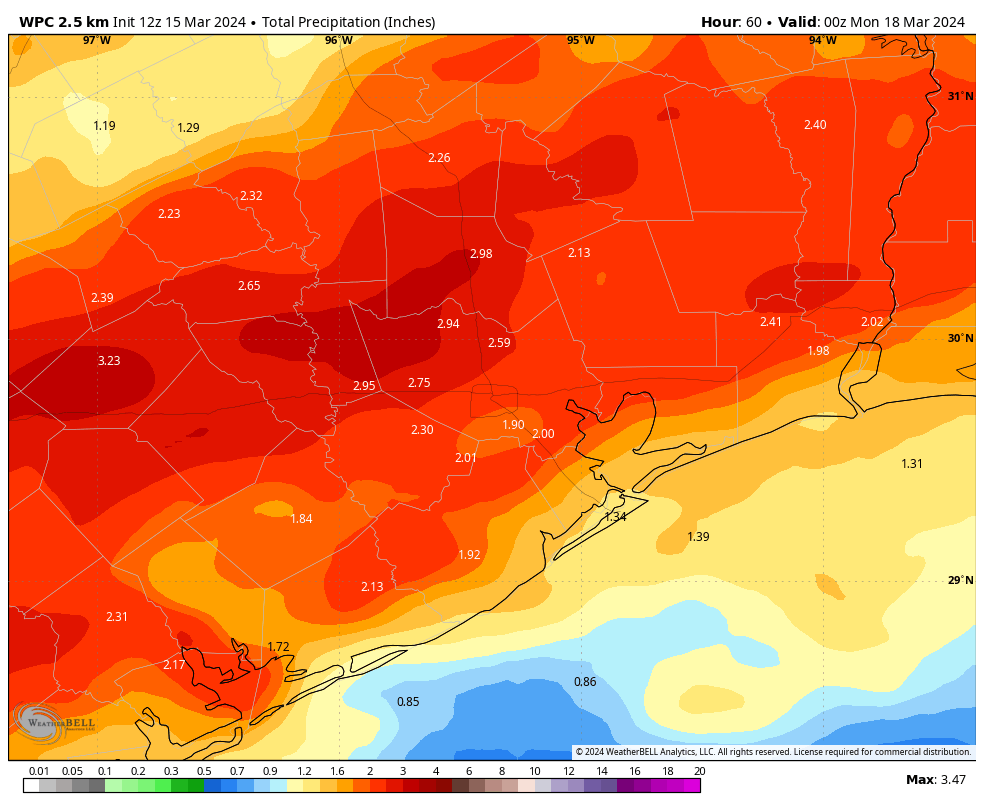
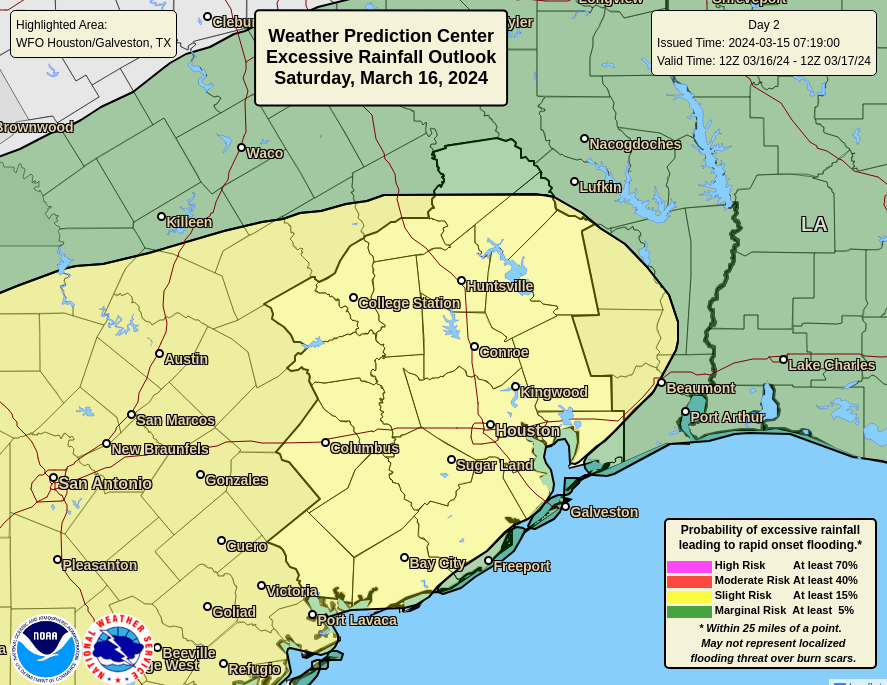
Summary: Houston faces the prospect of a wet weekend, with the stalling of a cold front nearby. There is the potential for severe weather, in the form of strong thunderstorms and possibly some hail, but for the most part the major watch item is moderate to heavy rainfall. Chances appear to be best from midday Saturday to midday Sunday. Some street flooding in low-lying areas is possible.
Friday
A check of the radar this morning reveals fairly widespread showers and thunderstorms to our west, between Sealy and Austin. Some of that activity is expected to work its way into Houston this morning, but we’re likely to see scattered, light showers for the most part. These should clear out by late morning, and I actually expect to see a few hours of sunshine during late morning or early afternoon.
As a result I expect temperatures to briefly pop up into the low- to mid-80s this afternoon. This heating should help produce conditions somewhat more favorable for rain showers late this afternoon and during the evening hours. I’d expect to see some of this activity approach from the west a couple of hours before sunset and then push into Houston.

Rodeo forecast
For the first time in a while this year, we have the potential for some dynamic weather during the Houston Livestock Show & Rodeo this evening. It’s no slam dunk, but there is the chance of some rain and possibly strong thunderstorms during the 6 pm to 8 pm time frame this evening for much of the central and northern Houston area. By no means will everyone see rainfall or storms, but the potential is there. As you head out to the show this evening, please be weather aware. Temperatures, otherwise, will be mild, in the 70s. This chance of showers and thunderstorms will persist through about midnight.
Saturday
We may well see a reprieve from activity overnight, and into the morning hours of Saturday. But some time, perhaps around noon, we should see rain showers building up over the area. This pattern should persist for about the next 24 hours, with the threat of on-again, off-again shower activity lingering into the middle of Sunday. Not all areas will see heavy rain, and I think there may be a fairly wide variance in rain totals. But most areas can probably expect to pick up between 1 and 4 inches of rain through the weekend. Highs on Saturday will likely top out in the mid-70s, with cloudy skies. Lows on Saturday night will drop into the 60s.
Sunday
The overall wet pattern will continue through at least Sunday morning, and potentially into the early afternoon hours as the aforementioned front slowly pushes through the area. Highs on Sunday will be in the 70s, again. We may see some partially clearing skies during the afternoon hours, but we’ll have to wait for the evening or overnight hours for substantially drier air to move in. As a result it now appears as though lows on Monday morning will only drop to around 60 degrees.
Next week
It will be pretty darn nice. Monday and Tuesday should bring at least partly, if not mostly, sunny skies back into Houston. We’ll see highs in the 60s and 70s, with drier air, and lows in the 40s and 50s (warmer near the coast, and cooler inland). The forecast starts to get fuzzy by mid-week, with chances for rainfall returning by Wednesday or Thursday along with highs of around 80 degrees.
Site note
We’ll update on the potential for heavy rain on Saturday and Sunday, and any flooding chances, if necessary.

I can be okay with the rain, even the soaking rain. Ixnay on the hail, though.
Let it rain. Please.
Amending my previous comment:
Liquid form only please.