Good morning. After several days of tumultuous conditions, Houston’s weather pattern will now turn much more predictable. The overall pattern looks sunny, and after today, rather warm for the foreseeable future. There is little to no rain in the forecast.
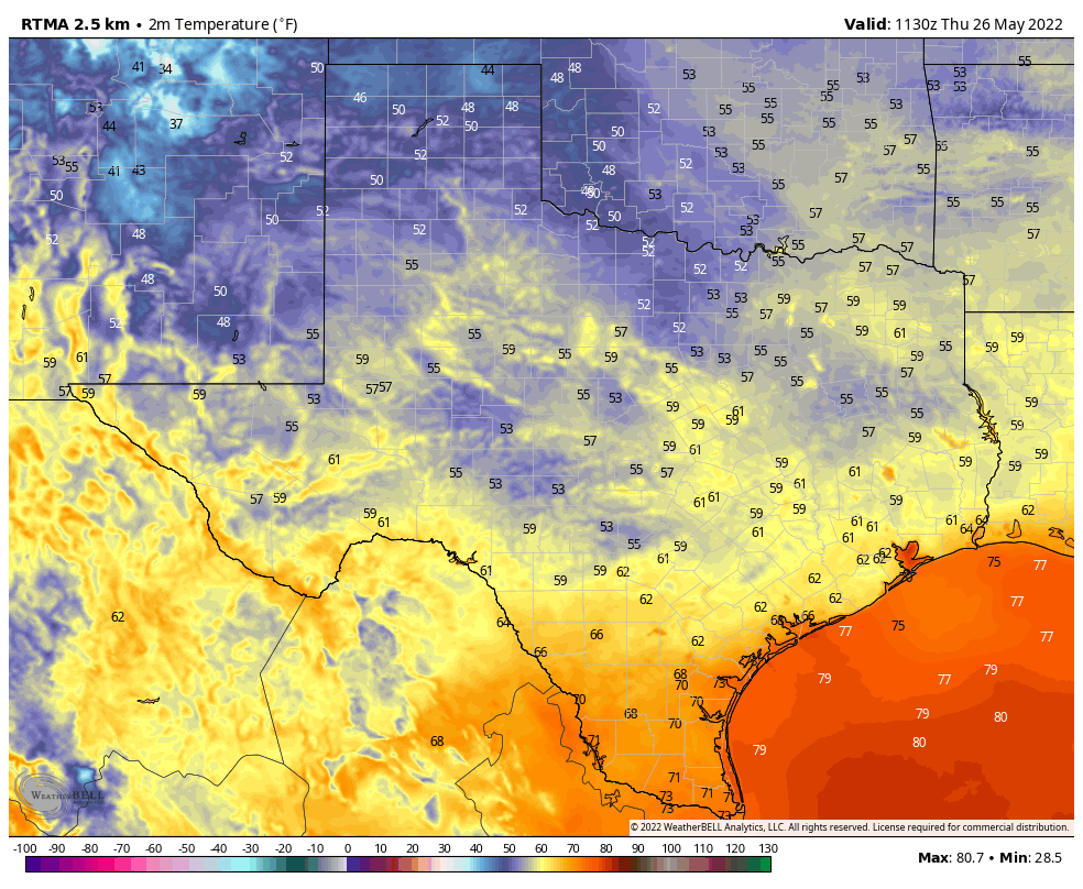
Temperatures at 6:30 am CT in Texas are rather cool for late May. (Weather Bell)
Thursday
Conditions are gorgeous this morning across the metro region, with temperatures generally in the 60s. This is a fine day for late spring, and will almost certainly be our coolest morning until at least September. At that point we’ll be looking to celebrate Fall Day, when the region’s first real front moves into the area, and I’m excited to say we’re hoping to do something special at Space City Weather whenever Fall Day comes this year. Anyway, after the cool start this morning, highs today will reach about 90 degrees beneath sunny skies. But with dewpoints in the 50s, conditions won’t feel quite so humid. Winds are already returning out of the south, however, so the dry air will be fleeting. Lows tonight should drop into the upper 60s for much of the metro area.
Friday
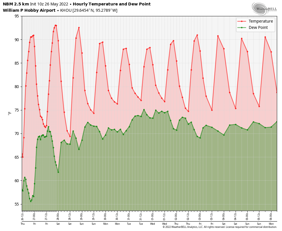
Friday will be sunny and hot, with highs in the low 90s. Winds will blow out of the south at 5 to 10 mph with slightly higher gusts.
Those sweet dewpoints in the 50s (green) will unfortunately not last. (Weather Bell)
Saturday, Sunday, and Monday
The Memorial weekend holiday will bring lots of sunshine and highs generally in the low 90s. Overnight lows will rise back into the low 70s by Monday morning. There really are no weather concerns for the holiday weekend aside from making sure you’re protecting your skin from prolonged Sun exposure.
Next week
The overall pattern next week will feel fairly summer-like, with partly to mostly sunny days, and the potential for isolated showers during the afternoon as the sea breeze gets fired up with daytime heating. Highs probably will remain in the low 90s to start the week, but may creep up toward the mid-90s late next week. We’ll see. While a tropical disturbance may form in the Southern Gulf of Mexico or northern Caribbean Sea late next week, there’s no reason to believe it will have any sensible effect on Texas.
Good morning. If you’re a light sleeper like me, you probably had a rude awakening during the wee hours of Wednesday morning. The good news is that the strong storms have passed. And while there may be some scattered showers this afternoon, we can look forward to an absolutely splendid springtime reprieve during the next day or two, with lows dropping into the low 60s tonight and drier air on Thursday. Summer will be fully upon us by the weekend, so enjoy this.
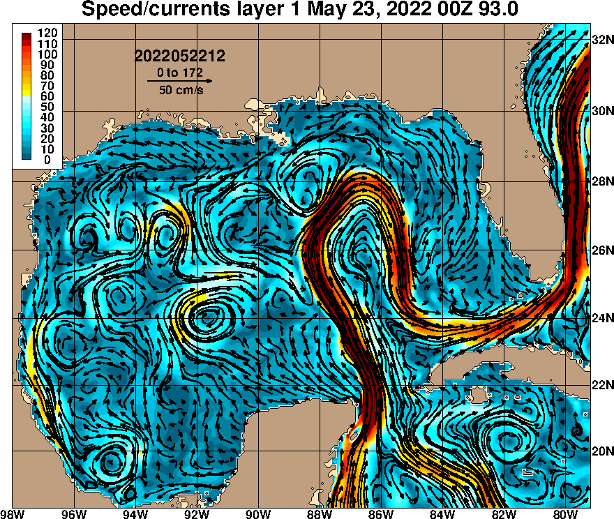
Loop Current concerns?
Before leaping into the forecast, I also want to say a few words about the Loop Current. In recent days I’ve seen a lot of coverage of this phenomenon across various media, and as best I can tell it all stems from an article published by respected meteorologist Jeff Masters eight days ago. Jeff’s article is fine, and describes a well known (to meteorologists, at least) phenomenon known as the Loop Current. This is essentially a sub-surface “river” that carries warmer water from the Caribbean Sea into the Gulf of Mexico. It is almost always present. Once or twice a year a circulation, or “eddy,” of warmer water will break off from the bulging Loop Current and drift into the central or western Gulf of Mexico.
Loop Current representation as of May 23, 2022. (US Navy Research Laboratory)
The key thing to understand is that when hurricanes cross the ocean, they churn up cooler water from below, which acts as a brake on strengthening. But when a storm passes over the Loop Current, or an eddy, the water below is warmer, thus supporting rapid intensification of a hurricane. Jeff’s report basically says that the Loop Current is fairly prominent this year and an eddy may break off later this summer. If that happens, it would be one factor supporting the intensification of Gulf hurricanes. While that may sound scary, it’s important to reiterate that the Loop Current is present virtually every hurricane season, often with an eddy. So while it’s a factor to consider, it’s not something that will necessarily juice the Atlantic season. And it’s not in any way abnormal. Overall, forecasters already expect a busier than normal season, but perhaps not excessively so. We’ll find out soon enough.
Wednesday
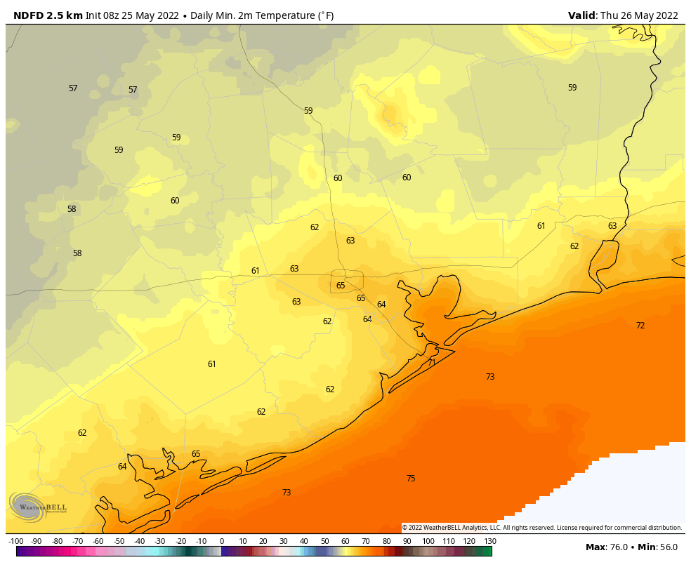
With the bulk of the storms moving off to the east, the Houston region should see a cloudy and fairly cool day. Most of the region will probably top out in the 70s today, something which may not happen again until October or even November. So that’s pretty remarkable. The big question is whether a secondary line of showers will fire up as the cold front itself passes through this afternoon. I’m leaning toward no, but it is possible that areas along and south of Interstate 10 may see some additional light to moderate rain later this afternoon as the front pushes through. After this we’ll see rapid clearing of skies this evening, which will allow temperatures to drop into the low 60s on Thursday morning. Winds will be out of the north at 5 to 10 mph.
Low temperature forecast for Thursday morning. (Weather Bell)
Thursday
What a day for late May. Expect highs in mid- to upper-80s with sunny skies to go along with light southwest winds. There should be enough dry air for a pleasant Thursday evening, but overnight lows will probably be about 5 degrees warmer than Wednesday night. Spring will definitively end after Thursday night, but I for one am appreciating the much needed rain and brief taste of cooler weather before the inevitable onset of summer in Houston.
Friday
Look for sunny skies, highs around 90 degrees, and light southwesterly winds.
Memorial Day Weekend
The holiday weekend will see sunny skies, highs around 90 degrees, and plenty of humidity. It certainly could be hotter for Memorial Day weekend. Overnight lows will be in the mid-70s, generally.
Next week
Overall I don’t expect much of a pattern change next week. Some slight rain chances return to the forecast by Tuesday or Wednesday. We’re also watching the possibility of a tropical disturbance forming in the southern Gulf of Mexico about a week from now, but there’s no indication it will have a meaningful impact on Texas. So, really, no worries at this time.
Just wanted to provide a quick update on an approaching cold front that will push a line of thunderstorms, some of them severe, into the Houston metro area early on Wednesday morning. The main threats will be damaging wind gusts as well as heavy rainfall. In terms of timing, the line of storms should reach the College Station area shortly after midnight, push into the central Houston region around 4 am, and be off the coast by about 6 am.
Matt and I discussed issuing a Stage 1 flood alert for this storm, but ultimately we decided not to. First of all, the storms look to keep moving along at a good clip as they push through the region. So while rains may be intense, accumulations probably won’t be above 1 or 2 inches for most locations. (Some isolated areas, of course, will probably see more). And given the timing of these storms, they should affect the bulk of the metro area before sunrise. So as the morning commute gets going on Wednesday, the worst should be over for Houston. For areas further east, such as Beaumont-Port Arthur, the timing is such that the storms will be hitting around 6 to 8 am.
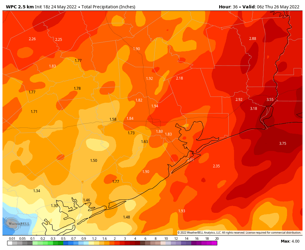
NOAA rain accumulation forecast for now through Wednesday. (Weather Bell)
It’s always possible that these rains come in heavier than we’ve forecasted above, but for now I think accumulations will be manageable, and certainly our soils need these rains. Some additional scattered showers will be possible later on Wednesday afternoon, but I think overall chances are low, especially after a much drier air mass moves into the region during the late afternoon and evening hours. Thursday morning should be absolutely spectacular.
Good morning. The main event for our near-term weather is the arrival of a cold front late tonight that will bring a line of storms through our area early Wednesday, likely reaching the metro area shortly before sunrise. This front will usher in some briefly drier air, with Thursday looking especially spring-like with morning lows possibly in the low 60s. Memorial Day weekend looks warm and sunny.
Tuesday
Yesterday I talked about the potential for an upper-level system to bring some showers and thunderstorms into the metro area on Tuesday morning, but noted that all of the ingredients might not come together for the showers to hit Houston. Well, they haven’t, and the bulk of the rain will remain offshore today. Accordingly rain chances are only about 50 percent today, and any scattered showers that move through should do so fairly quickly from southwest to northeast. Otherwise, expect mostly cloudy skies today with highs in the mid-80s. Winds may gust as high as 20 mph out of the south.
Tuesday night and Wednesday
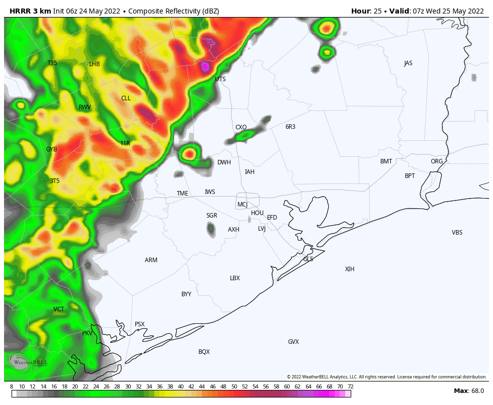
I’m more confident in the arrival of a cold front tonight, likely reaching the College Station and Conroe areas around midnight, pushing into central Houston around 2 to 4 am CT, and off the coast by sunrise. A line of storms will accompany the front, bringing thunderstorms, straight-line winds, hail, and even the potential for a tornado or two.
HRRR model depiction of a line of storms approaching Houston at 2 am CT on Wednesday. (Weather Bell)
I expect that some of these thunderstorms will bring heavy rainfall, and overall accumulations will probably range from 1 to 3 inches for most of the metro region, with higher isolated totals. While the bulk of the rainfall should have passed by around sunrise on Wednesday, some light to moderate showers may linger into the late morning hours. High temperatures on Wednesday should top out in the upper 70s as skies probably won’t start to clear until Wednesday evening.
Thursday
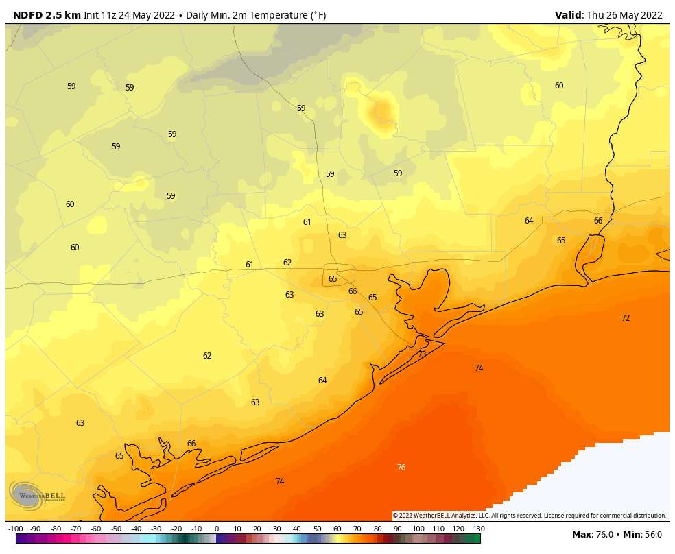
This is going to be a pretty amazing spring-like day in Houston, especially for late May. Lows will start out at 60 to 65 degrees, and despite sunny skies we’re going to see temperatures likely top out in the mid-80s. With dewpoints in the low 60s, the air will also feel reasonably dry. The evening should be pretty great as well, with some drier air holding on and temperatures dropping. Lows on Thursday night should eventually fall into the mid-60s.
Low temperatures on Thursday morning will be pretty incredible. (Weather Bell)
Friday
This will be a transition day back to more summer-like weather, but there still should be a smidge of drier air, with highs in the upper 80s, sunny skies, and overnight lows dropping to around 70 degrees.
Memorial Day Weekend
The forecast over the weekend will bring three days of sunny skies, highs around 90 degrees, and lows in the 70s. It will be plenty humid outside, but not boiling hot as this holiday weekend can sometimes be. Conditions should be perfect for outdoor activities, although please be sure and protect yourself during prolonged exposure to the sun.
Next week we’ll be monitoring the potential for a tropical disturbance to form in the Bay of Campeche, in the far southern Gulf of Mexico. This may eventually bring some moderate rainfall our way next week, but right now it’s not something to be concerned about at all.