Widespread rain today, then chilly for the remainder of the week

Nearly two weeks ago, we predicted that the “rest of January” would feel rather winter-like for Houston. Since that time, with one exception, nighttime temperatures have been in the 30s and 40s. Now, it’s safe to say the rest of this month will remain on the colder side of things. This week will see high temperatures generally in the 50s, with lows in the 30s and 40s.

Monday

The story for today will be widespread rain showers due to the proximity of a low pressure system near the coast. During summer time, such a system would have greater atmospheric moisture levels to work with, so we’d be more concerned about heavy rainfall. In this case, however, most areas will likely pick up 0.5 to 1.0 inch of rain as light to moderate showers ebb and flow across the region. Coastal areas could see a bit more than this, but we’re really not expecting anything too extreme. With leaden skies, high temperatures today should peak in the mid-50s, before dropping into the upper 40s tonight.

NOAA rain accumulation forecast for now through Tuesday. (Weather Bell)

Tuesday

Rains should end on Monday evening as the system pushes off to the east, and this will help to pull in a surge of cooler and drier air on Tuesday. Temperatures should reach about 60 degrees in Houston on Tuesday, with partly to mostly cloudy skies and northerly winds, before lows Tuesday night drop to around 40 degrees.

Wednesday and Thursday

These should be a pair of partly to mostly sunny days, with highs in the mid-50s and overnight lows dropping into the low 40s.

Friday, Saturday, and Sunday

Another front should arrive on Thursday night, possibly bringing some more light rain into the area. This front will help keep temperatures on the cool and sunny side for most of this weekend, with highs in the 50s on Friday and Saturday, and perhaps the mid-60s on Sunday. It looks like Saturday morning will bring the coldest temperatures this week, with a light freeze possible for much of the area.

Saturday morning should be the coldest of the week. Here’s a preliminary forecast for temperatures. (Weather Bell)

This time there likely will be no front to end the warming trend, so temperatures should jump up into the 60s or perhaps lower 70s by Monday, and we may also see an increase in rain chances later on Sunday and into Monday, but the details of all this will remain fuzzy for now.

The bottom line is that as the calendar turns toward the end of January, we’re really into the depths of winter for Houston now, and weather this week with consistently “cold” days is going to feel like it for our southern region. Enjoy or disapprove at your discretion!

No, Houston doesn’t face an Ice-apocalypse or Snow-mageddon

Good morning. After Wednesday evening’s storms, our focus now turns toward cold weather ahead and the potential for some sleet or freezing rain to fall across the area on Thursday night. The bottom line is that we don’t think much freezing precipitation (if any) will fall across the Houston region, and it is unlikely to be impactful.

Thursday

Temperatures are generally in the low- to mid-40s this morning across Houston, but with a brisk northerly wind it feels colder than that. The mercury will not rise today, as temperatures remain in the 40s, due to overcast skies and the ongoing incursion of colder northerly air. Although the storms associated with Wednesday night’s cold front have moved offshore, as an atmospheric disturbances moves overhead later today, some light rain will again become possible this afternoon and overnight.

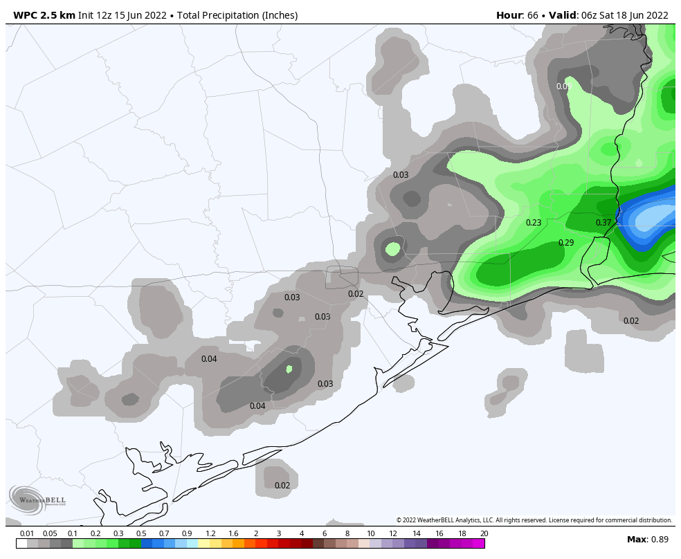
Potential rainfall accumulation on Thursday evening and overnight. (Weather Bell)

The atmosphere will have dried out enough that inland areas, north of Interstate 10, are unlikely to see much precipitation. However, areas along and south of Interstate 10 may see a few hundredths to tenths of an inch of rain. As temperatures fall tonight, some of this precipitation may take the form of sleet or freezing rain. However, it will be a race between falling temperatures and ending precipitation to see if we get any wintry precipitation in the Houston region. For now, the most likely answer is that the rains end before the atmosphere gets sufficiently cold to produce sleet or freezing rain (snow is very unlikely). The good news is that surface streets should remain above freezing so any wintry precipitation is unlikely to stick. If this forecast changes, we will of course update you later today.

The story may be different for other parts of Texas, particularly if you’re headed southwest of the Houston metro area, beyond Fort Bend County. There is a better chance of more sticky freezing rain in these area. For example, there is a Winter Storm Warning for the Coastal Bend area tonight.

Friday morning’s low temperatures. (Weather Bell)

Friday

This will be another gray day to start out, with highs likely only peaking in the mid- to upper-40s. However, any lingering precipitation should wrap up around sunrise, and skies should begin to clear out during the afternoon hours. This will set the stage for a colder and drier night, with much of the Houston region likely seeing a light freeze.

Saturday and Sunday

The weekend looks clear and cold, with partly to mostly sunny skies and highs in the 50s, and overnight lows in the upper 30s to 40s.

Next week

Monday should see widespread rain showers as a low pressure system nears. Most likely accumulations will be 1 inch or less, but we’re keeping tabs on the potential for higher totals due to available moisture. Otherwise expect highs in the 50s, possibly rising to the 60s by Tuesday. After this point another front arrives to push highs back into the 50s. Another freeze next week seems unlikely, although not impossible, as winter-like conditions hang around.

Strong cold front arrives tonight, with sleet or ice possible Thursday night

Good morning. We have a complicated forecast for Thursday night in Houston, so that’s what most of this post focuses on.

Wednesday

It’s a mild morning across the Houston region, and we’ll see a warm and partly sunny day with highs in the mid- to upper-70s. Some isolated to scattered showers will be possible this afternoon as a cold front nears. A more organized line of storms will probably form along the front itself, reaching areas such as The Woodlands and Katy between 6 and 9 pm CT, central Houston an hour or two later, and the coast by or before midnight. These storms may briefly bring strong wind gusts and the chance of some hail as they blow through. Accumulations will range from 0 to 0.5 inches for most locations, with higher amounts possible near the coast. Following the front, winds will be brisk out of the north, gusting up to about 25 mph. Temperatures will plummet.

There is a slightly better chance of severe weather on Wednesday evening for East Texas. (NOAA)

Thursday

By Thursday morning, temperatures outside will be in the upper 30s for inland areas, and low 40s for the urban core of Houston and closer to the coast. This will be a mostly cloudy day, and with the winds it will definitely feel cold outside. Some spotty rain showers may linger during the daytime as there will be a slug of more moist air aloft. The big question is what happens on Thursday evening and the overnight hours as a disturbance approaches our region, which combined with falling temperatures and this atmospheric moisture, may produce some kind of winter precipitation.

If I can be blunt for a moment, I will say that forecasting snow, sleet, freezing rain or other winter precipitation in the Houston region is like living on a knife’s edge. Very small differences in temperature, at different levels in the atmosphere, determine whether sleet, snow, or rain falls. Because we are so close to the relatively warm Gulf of Mexico, it is difficult get a really cold atmosphere from the surface all the way to the stratosphere, which is required for snow. So our overall confidence in this forecast is low.

How different types of winter precipitation form. (National Weather Service)

With that said, as temperatures fall on Thursday evening there will be a chance for light rain to transition to some kind of winter precipitation. For the Houston metro area, we probably won’t see snow, as there will be pockets of warmer air aloft that will melt any snow and re-freeze it into sleet. The good news is that any rain transitioning to sleet or ice on Thursday night should not produce significant accumulations, and at this time roads and bridges should be warm enough to mitigate against any serious effects.

The bottom line: Thursday will be cold, and there is a window during Thursday night where light precipitation could fall. This may mean we see a few ice pellets or, less likely, a few snow flurries. But for now we don’t see serious effects on Houston’s roadways by Friday morning. We will of course continue to track this closely and have a comprehensive update on Thursday morning.

Friday

In any event, temperatures will warm into the 40s on Friday, with clearing skies. Winds will start to die down as well, and this will set up ideal conditions for cold weather Friday night into Saturday morning, with a light (dry) freeze likely across much of the metro area.

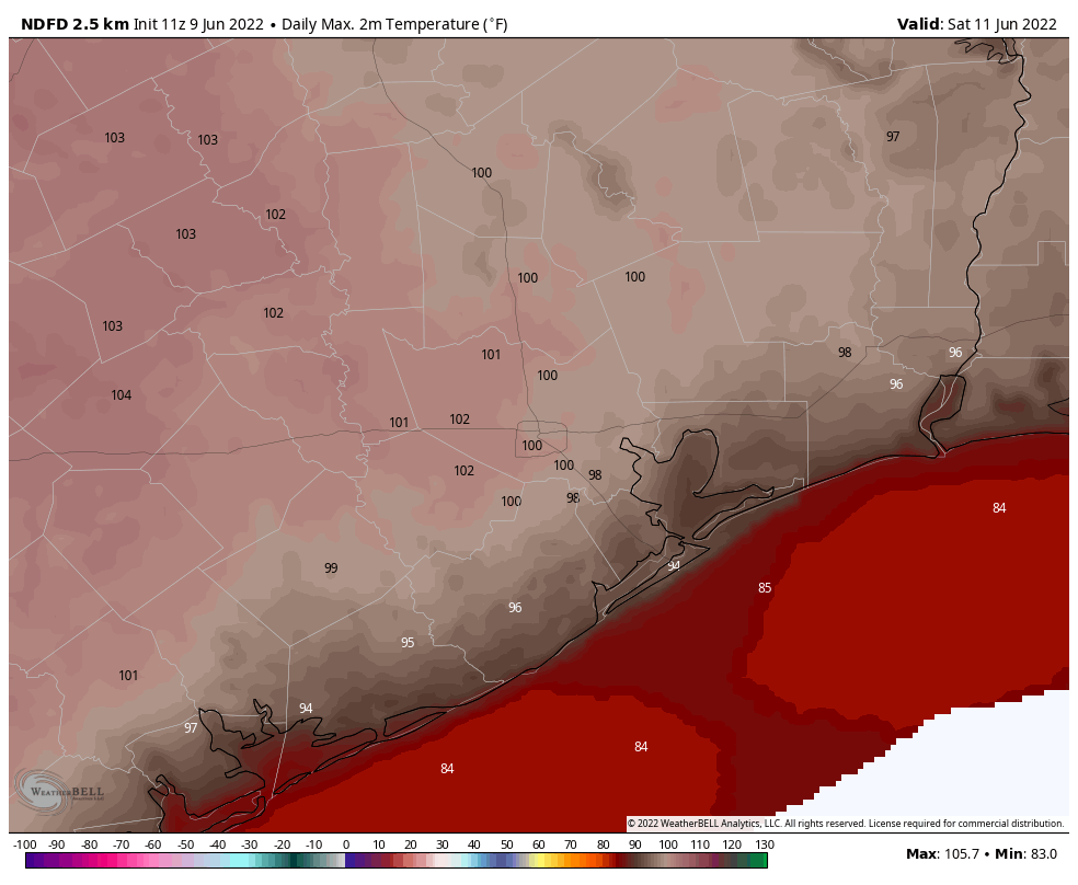
Saturday morning will be quite cold for the Houston region. (Weather Bell)

Saturday, Sunday, and beyond

The weekend looks partly to mostly sunny, with temperatures in the low to mid-50s. Lows Saturday and Sunday night should drop to around 40 degrees, give or take. Some slight rain chances return on Sunday, with better ones by Monday as low pressure moves into the region. Highs may get to around 60 degrees by Tuesday before the next front arrives to keep our weather on the cooler side. Expect sunnier weather after next Tuesday, with highs perhaps in the 50s, for awhile.

Colder air looms for Houston, with a “wintry mix” possible for inland areas

Good morning. We’ve got a fairly complex forecast for the week ahead, including some reasonably cold winter weather and the potential for some light sleet, ice, or snow later this week. There’s nothing to be too concerned about, but any little bit of wintry mix is worth discussing for this southern region.

Tuesday

We have absolutely no weather concerns for today, which should yield absolutely splendid weather. Skies will be partly to mostly sunny, with light southerly winds. As a result, highs should climb into the low 70s, with enough dry air outside for conditions to be most pleasant. Humidity levels will creep up a bit tonight, and overnight lows will only drop to around 60 degrees. This very likely will be the warmest night for the rest of January in Houston, because things are about to take a turn for the colder side of things.

Wednesday

Just as Tuesday night may be the last “warm” night of this month, Wednesday could be the last warm day for January. The day will start partly sunny, and I expect highs to at least get into the mid-70s. However, clouds should start to build during the late morning or early afternoon hours, and this is when we’ll start to see a chance of scattered showers and perhaps a thunderstorm or two.

There is a marginal chance of severe weather for our region on Wednesday evening. (NOAA)

As the front approaches, likely reaching our northwest areas before midnight, the central Houston area around midnight, and the coast a couple of hours later, a few stronger storms may develop. We may see some brief, small hail or possibly a tornado, but for the most part I think the region will just pick up between 0 and 0.5 inch of rain. Any severe weather that develops is likely to do so near the coast, or in the vicinity of Galveston Bay. Temperatures will drop sharply after the front’s passage.

Thursday

We’ll wake up in the 40s on Thursday morning, and due to overrunning moisture higher in the atmosphere skies will remain cloudy and cold. Brisk northerly winds, with gusts of 25 mph or higher, will make it feel quite chilly. Highs on Thursday may remain in the 40s or possibly reach 50 degrees, with the ongoing potential for light rain. The question is whether this light precipitation persists into Thursday night.

Outlook for Thursday night. (National Weather Service)

If it does, as temperatures fall to freezing for inland areas, we could see rain transition to sleet, ice, or snow. While any amount of ice is a concern, at this point we don’t see much potential for accumulations. This wintry mix is most likely to occur north of Highway 105, but if you live north of Interstate 10, or will be traveling those roadways later on Thursday night, this will be something to monitor just in case. We’ll remain on top of it for you.

Friday

Conditions improve somewhat on Friday, with lighter winds, and drier air moving in from the north to end any lingering rain. Although the sun makes an appearance during the afternoon hours, highs should again be in the 40s for most. Clearing skies will allow for an even colder night Friday, with much of the region possibly seeing a light freeze early on Saturday.

With clearing skies, Saturday morning should be quite cold in Houston. (Weather Bell)

Saturday and Sunday

The weekend looks cold, but at least it should be mostly sunny. Look for highs on both days to slot in around 50 degrees or a tad warmer. Lows should be in the upper 30s for Houston, with slightly warmer conditions along the coast.

Next week

A chance of rain returns to the forecast early next week, and highs should eventually recover into the low 60s. Nights will likely remain in the 40s, however, as winter’s chill sticks around this time. Late January really is the “dead” of winter for our region, so these colder conditions are to be expected.