The heaviest rainfall today has fallen east of Houston, from Chambers County to Lake Charles, Louisiana. Some locations have received more than 12 inches of rain and some serious flooding is underway.
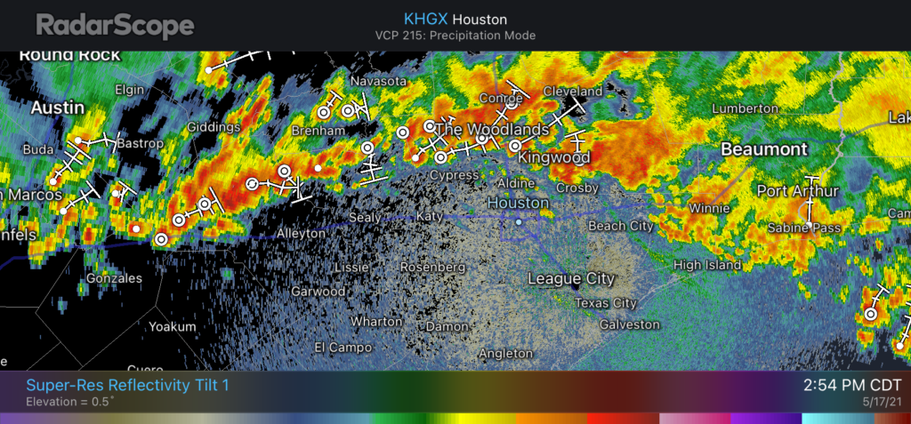
Closer to Houston, a slow-moving band of showers has established itself just north of the Houston metro area. We expect this line of showers to slowly progress southward toward Interstate 10, and perhaps the coast, later this afternoon and evening. In the heaviest storms we’re seeing rainfall rates of 2 to 3 inches per hour, which is enough to quickly back up streets. Unfortunately, these storms will probably affect the central Houston area during the evening commute home. Plan accordingly.
Radar just before 3pm showing a line of storms what will sag south. (Radar Scope)
These storms should begin to wind down as the sun sets, and we anticipate a reprieve overnight. Matt will have an update later today on the latest for what we can expect on Tuesday and Wednesday in terms of rainfall and flooding.
Good morning. We’re entering day two of a period that has the potential to bring significant rainfall and flooding across the metro area. The pattern is threatening because it may produce both short-term, intense rainfall as well as prolonged, widespread showers. Most of us should be fine in the end, but this kind of setup is worth monitoring very closely.
We are going to implement a Stage 2 alert on our Flood Scale for two reasons. While we do not think most of the area will see significant flooding, we do believe there is definitely the potential for localized flash flooding, especially on Wednesday and Wednesday night. Second, soils across the area are already wet, with reservoirs at full capacity.
Monday
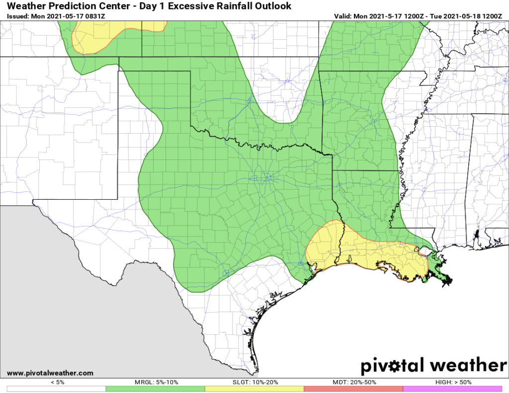
Our overall confidence in the forecast today is low. While there is the potential for heavy rainfall, there is also some drier air in the atmosphere, and this may limit activity over the Houston region to scattered showers and thunderstorms. In any case, the best chance for heavy rainfall will lie just east of Houston, along Interstate 10 and heading into Louisiana. For the Houston area, most of us can probably expect accumulations of 0.25 to 1 inch of rain. Skies will otherwise be mostly cloudy, with highs in the low- to mid-80s. Rain chances back off tonight.
Potential for excessive rainfall on Monday and Monday night. (Pivotal Weather)
Tuesday
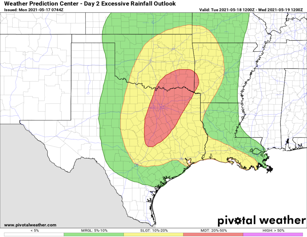
The disturbance in the upper atmosphere that is driving all of this unsettled weather will move closer to our region, and therefore the chance of heavy rainfall will increase somewhat on Tuesday, especially north of Interstate 10. (This could be a serious day for flooding in the Dallas-Fort Worth area). However, this does not mean the day will necessarily be a washout in Houston. I expect rainfall accumulations for most to average 0.5 to 1.5 inches, with the potential for more of course. Highs again will be in the 80s.
Potential for excessive rainfall on Tuesday and Tuesday night. (Pivotal Weather)
Wednesday
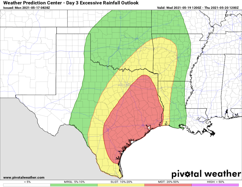
We still think Wednesday and Wednesday night will be the period that brings the best chance of heavy rainfall and flooding to the Houston metro area. This is when the upper-level low pressure system will pass more directly overhead. Basically, there should be enough moisture and lift to produce some very heavy rainfall. But whether the epicenter of this occurs along the coast somewhere from Matagorda Bay to Galveston, more inland over Houston, or north of The Woodlands, we just cannot say right now. I think most of the area will see 3 to 6 inches of rain from Tuesday night through Thursday morning, with the potential for some pockets of 10 inches or more. Where that occurs we just don’t yet know. This uncertainty is reflected in the large red area in the excessive rainfall forecast below.
Excessive rainfall forecast for Wednesday and Wednesday night. (Pivotal Weather)
Thursday and Friday
We think the potential for really heavy rain will start to dial back on Thursday morning as the upper-level low exits, but there should still be a healthy chance of showers and thunderstorms on Thursday and Friday. Both of these days should see mostly cloudy skies, with highs in the low 80s.
Saturday and Sunday
Some sunshine should return by the weekend, but I think we’ll still see at least some scattered to widely scattered showers on Saturday and Sunday. Highs will be in the low to mid-80s. Skies should turn mostly sunny by early next week.
Matt will have an update by around 7 pm CT on Monday.
Good morning. We’re already starting to see the development of rain showers to our west and southwest, and this marks the beginning of what will be a very wet week for much of the eastern half of Texas. This activity will be driven by a slow-moving upper-level low pressure system and an increasingly moist atmosphere. There is a lot we still don’t know, but here’s an overview of what to expect.
Today
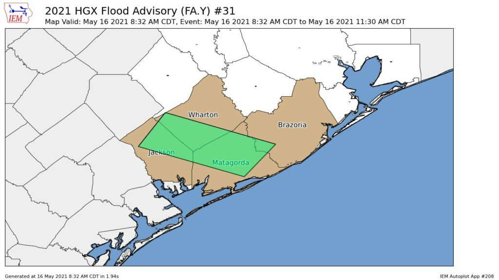
Storms will move from the southwest into the metro area later this morning, but we think their rainfall intensity will weaken a bit as they spread into Houston. Our general expectation is for 0.25 to 1 inch of rain for much of the Houston area, with higher totals to the southwest. The greater risk is over Brazoria, Wharton, and Jackson counties.
The National Weather Service has issued a flood advisory for this morning.
I-45 threat
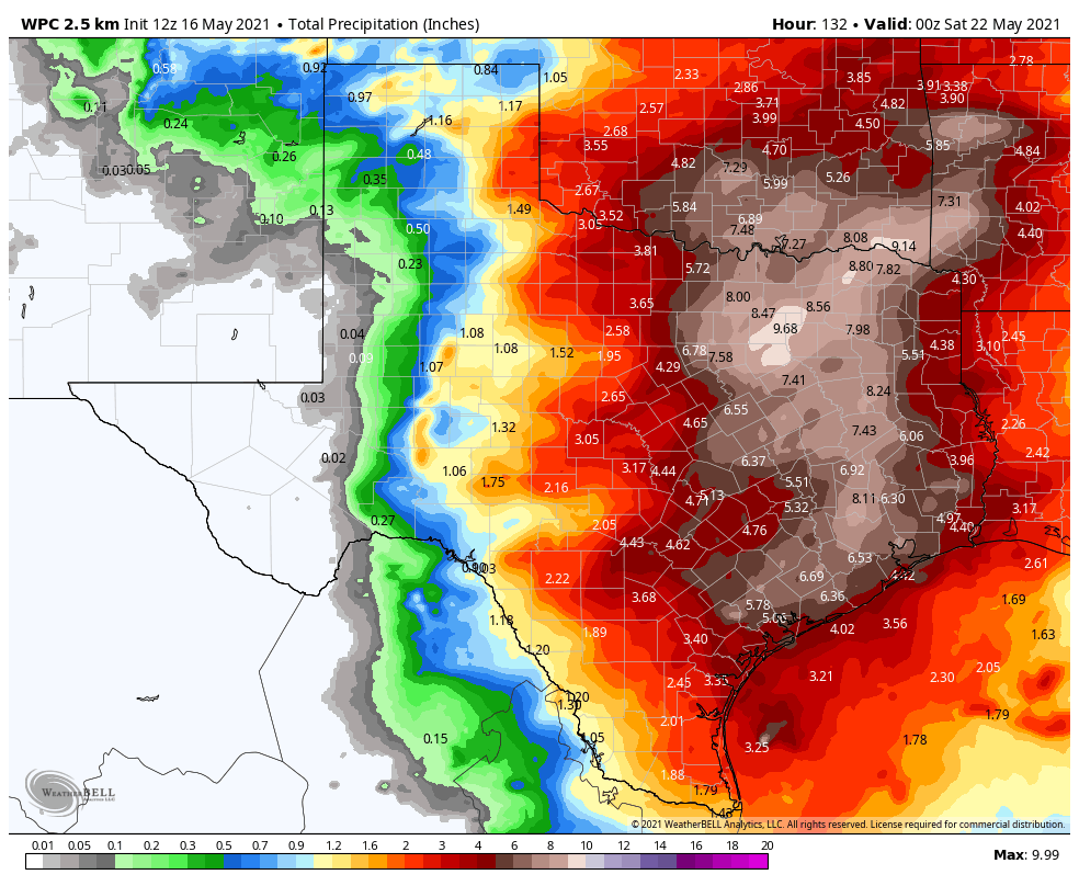
Much of the model guidance suggests that the biggest threat for heavy rainfall this week will come along the Interstate-45 corridor from Houston through Dallas, with 6 to 10 inches of rainfall coming between now and next Friday, with the potential for higher isolated totals somewhere. If you’re traveling to or from the Dallas Fort Worth area, take that into account.
Activity may spike Wednesday
The potential for heavy rainfall will exist every day this week given the overall atmospheric conditions, however we think the most active period will come on Wednesday or Wednesday night as the upper-level low pressure system moves directly overhead. This is when the potential for heavy rainfall should spike over the Greater Houston area, and we could see some flooding. However, given that we’re still more than three days from this time frame, we just don’t have that much confidence in the details for Wednesday and Wednesday night’s rainfall. We plan to implement a Flood Scale alert tomorrow, as we get better data.
NOAA rain accumulation forecast for today through Friday. (Weather Bell)
Rain chances continue through Saturday
Although the heaviest rainfall should end some time on Thursday, the threat of at least moderate rains should continue into Saturday before high pressure asserts itself.
Will there be flooding?
This is the big question. For most of the region, six inches of rain spread out over six days is really no problem. However, it becomes a problem if six inches come in a few hours, in which case we’ll see street flooding, and bayous begin to back up.
We’re starting from a point of reasonably dry soils, but if your area gets 1 inch today, another inch spread over Monday and Tuesday, and then 8 inches on Wednesday then there could definitely be problems. We just don’t know where this rainfall spike will occur. We’re fairly confident that some location between Matagorda Bay to Houston to Lake Livingston will see a bullseye of heavy rainfall on Wednesday or Wednesday night, and this will cause at least localized flooding. But where? We just don’t know yet.
Matt will have an update this evening, by 7 pm CT.
My wife and I first began thinking seriously about a whole-home generator last August, as Hurricane Laura barreled into the Gulf of Mexico and threatened Texas. Since we built a new home in League City in 2017, this was the first time a major wind storm threatened the upper Texas coast, and the fading memory of extended power outages during Hurricane Ike came back to me. Alas, the process of purchasing and installing a generator takes advanced planning, and it’s a big decision.
Eventually, we decided to go for it. So earlier this year I reached out to Reliant to inquire about a whole-home generator that is powered by natural gas. As a reminder, Reliant is the multi-year sponsor of Space City Weather. To note, I did not receive this generator for free, and I chose to purchase it with a portion of Reliant’s annual sponsorship fee. So, you can rest assured that my experience should be similar to yours.
Buying a generator capable of powering your entire home is a major investment. For the average homeowner in Houston, it will likely cost between $10,000 and $15,000. But for many, it may be a worthwhile investment—especially following the recent winter storm and annual threat of hurricanes for our area. With this post, I am going to describe the installation process and what you can expect if you decide to purchase a whole home generator.
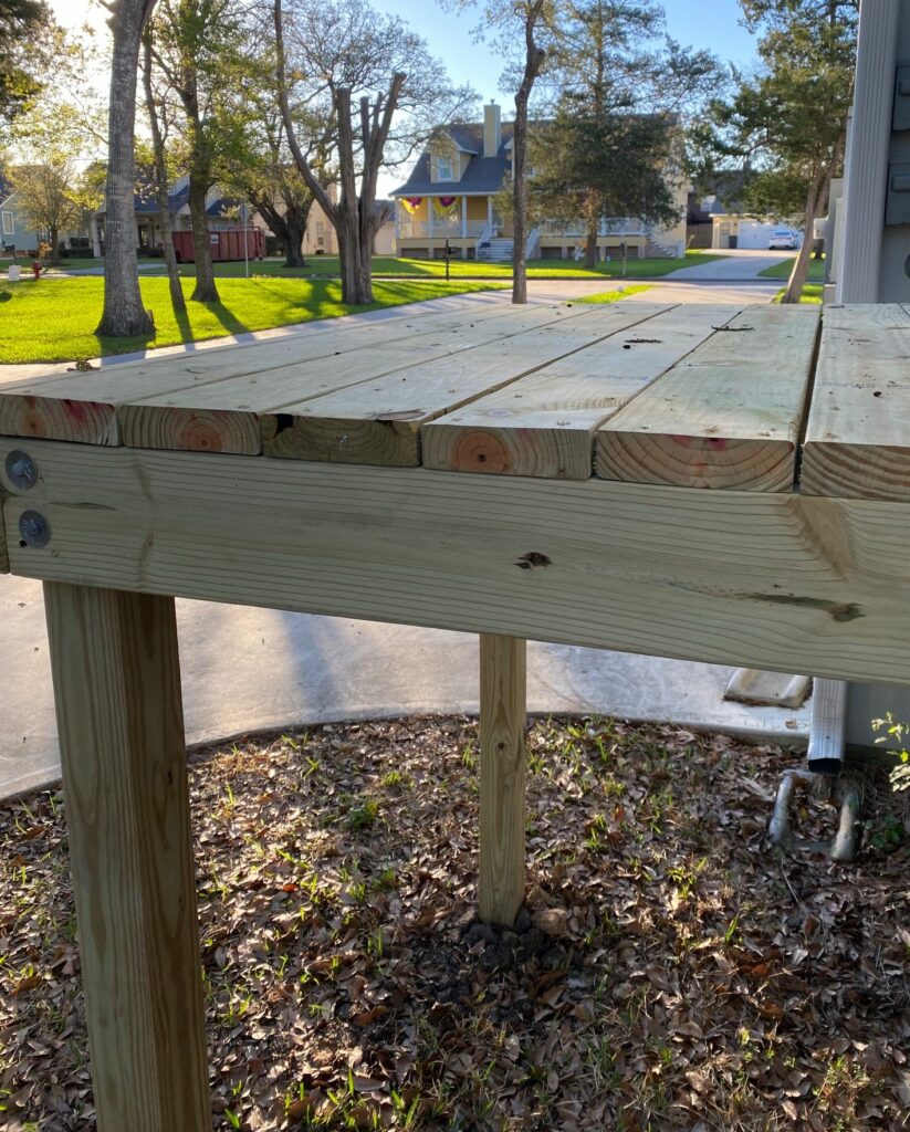
We needed to put the generator on a stand to meet local code.
The process begins with a home visit by a generator technician. Reliant works with a Houston-based company, Quality Generators, and they sent Mike to my home in mid-January. Over the course of nearly an hour, Mike and I discussed my home’s power needs, existing power and natural gas lines, and potential solutions. I really knew nothing about this, so it was great to have Mike help us navigate the process. He explained all of the costs and fees associated with buying the generator and installing it.
On February 1, we agreed to contract, and I signed it. I paid half of the purchase price up front. Then we put stakes into the ground, an outline of where a platform would be built, and where the generator would go outside my house. We tentatively planned an installation later in the month. And then, the Valentine’s freeze came to Houston. We lost power for days. I remember standing in my darkened home office, as the temperature plummeted into the teens, looking out the window at those stakes.
After the freeze ended, installation began in March. All of this work was communicated well in advance, with a schedule clearly laid out. Any time I had a question, I would call Mike. I appreciated that there’s a local service phone number that a real person answers. I received regular updates, by phone, of what to expect, and when to expect it. Then, after each job, someone would check in to make sure I was satisfied.
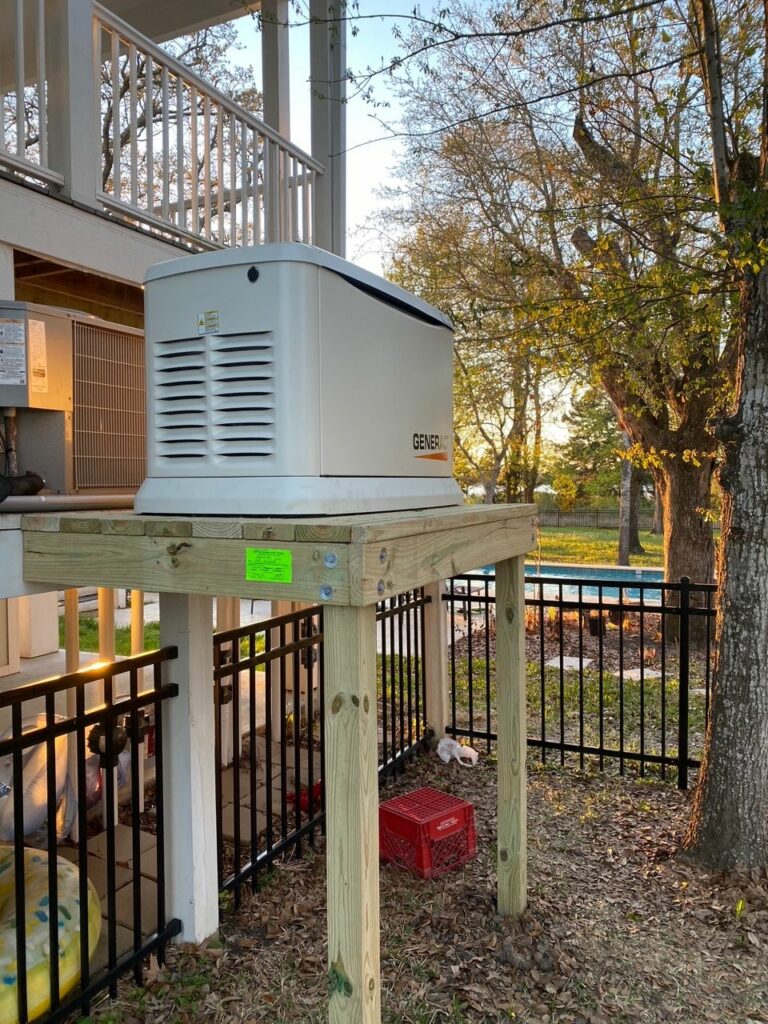
First, a team of workers built a stand, which took a couple of hours. (Sometimes, a generator is installed on a concrete pad, instead). A few days later came the installation itself. This process was more laborious and lasted most of the morning. It involved power being disconnected to the home for about two hours, which I was told of in advance. But after this, the generator was ready to go.
Houston, we have a generator.
A whole home generator is a back-up plan. When the electricity goes off, for whatever reason, the generator kicks on within seconds. The lights come back on. Depending on the size of the generator it can power some, or all, of your home’s electricity needs. Theoretically, it should provide continual power through an ice storm, a hurricane, or any other type of disaster. I have fortunately not had to test that yet, but it is comforting to hear the generator fire up once a week to ensure its readiness.
And that really is perhaps the biggest benefit of having a generator. You never know when the power is going to go out, especially in a region prone to severe storms. Every time there is inclement weather in the forecast, there will always be a little bit of concern. When you have a whole-home generator, it takes the anxiety away. And reliable power is especially important considering that during inclement weather we want to continue providing you with timely updates on Space City Weather!
The bottom line is that buying a generator is costly, and a big decision to make. But if you’re considering it, you want to make sure you’re working with a company that is experienced and established. My referral from Reliant for Quality Generators was a painless process. The people I worked with were friendly, knowledgeable, and happy to answer all my questions. If there’s a problem, I’m confident they’ll be there to help.
If you’ve been considering a whole home generator, Reliant customers can receive 10 percent off with the first year of maintenance free. Learn more here.