Enjoy what is probably our last real front of the season, Houston

Good morning. The cool front and its associated showers—which truly were hit and miss—have moved through the area during the overnight hours. This will set the stage for some slightly drier weather and sunny skies until Saturday night, when rain chances return to the area. This front isn’t packing too much oomph, but it is mid-May after all. And this may be the last real front of the season, so enjoy the nights and mornings.

Wednesday

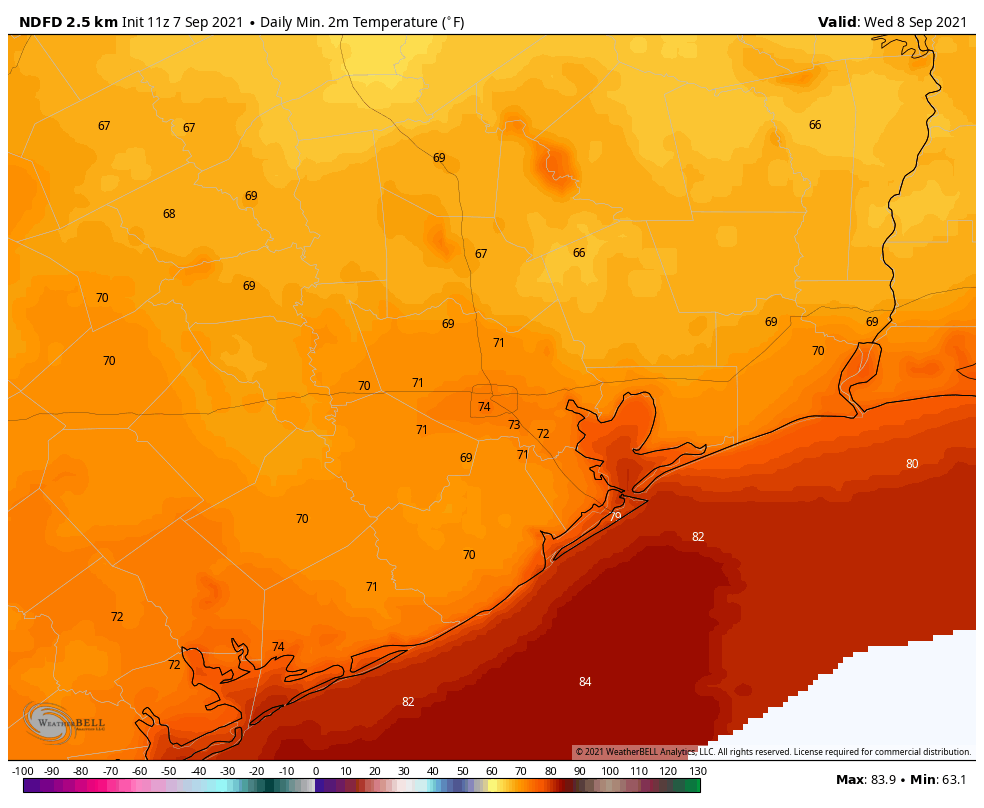
Most of the storms associated with the frontal passage have moved offshore, but we could see a few lingering showers this morning. Otherwise, skies will eventually transition from mostly cloudy to perhaps partly sunny this afternoon as winds blow from the north. Gusts could reach about 20 mph. Highs will generally reach into the mid-70s today, with overnight lows falling into the low 60s across Houston.

Low temperature forecast for Wednesday night. (Weather Bell)

Thursday and Friday

These will be a pair of partly to mostly sunny days, with highs in the upper 70s to 80 degrees. Nights will be cool, rather than cold, but the moderately drier air will still feel pretty good. Even coastal areas will see some drier air, although its effects will be muted.

Saturday

The onshore flow should resume some time on Friday, and this will begin to produce a few clouds. I still expect Saturday to have some sunshine, as highs get into the low 80s. Some rain showers will be possible later in the afternoon or evening, but I suspect these will hold off until the overnight hours. Saturday night will be warmer with the southerly flow, likely only dropping to around 70 degrees.

Sunday

Better rain chances arrive on Sunday, as the atmosphere turns a bit more disturbed. Accumulations don’t look too great, with perhaps a few tenths of an inch of rain for most areas. Highs should range from the low- to mid-80s across Houston, with a bit of sunshine when it’s not raining.

Will these be Houston’s last nights in the 60s until September? Probably. (Weather Bell)

Next week

Overall, next week should yield warmish, cloudy weather, with highs in the 80s and lows in the 70s. I don’t have a great feel on when rainfall chances will be highest, but forecast models indicate the week could be fairly wet with a few inches of accumulation. Details, as one might expect, are fairly hazy at this point.

Two wet days will precede a drier pattern for Houston

Storms have pulsed up overnight north of the Houston area, particularly in the Lake Livingston area, close to where a stationary front is located over Texas. This front will eventually slog its way down to Houston and off the coast, but in the meantime our region will see intermittent rainfall, some of which could be heavy. We do not have significant flooding concerns. Lovely late spring weather will move in later on Wednesday, after the front moves offshore.

Location of stationary front as of Tuesday morning. (National Weather Service)

Tuesday

It’s very warm this morning, with lows only getting down to about 80 degrees for some locations in Houston. As the front slowly moves south, I think we’ll see decent rain chances across the area north of Interstate 10, but showers will likely remain mostly scattered until tonight. This will leave us with a mostly cloudy day, therefore, and highs in the upper 80s. Winds out of the southeast may gust up to 25 mph.

Tuesday night and Wednesday

This is a difficult rainfall forecast, because I think some areas will see no rainfall over the next two days, while some isolated parts of the Houston metro area pick up 5 inches, or more. Most areas will probably see about 1 inch. As a general rule, I’d expect the potential for heavy rainfall to be greatest north of Interstate 10 through about midnight, and shift more toward the coast on Wednesday morning.

NOAA rainfall accumulation forecast for now through Wednesday night. (Weather Bell)

The potential for heavy rain should end during the afternoon hours on Wednesday, and any lingering showers should end by late afternoon. Daytime highs likely will climb only into the 70s, and lows will drop into the upper 50s to low 60s Wednesday night. While not exactly cool, this (and Thursday night) may nonetheless be the coolest weather Houston sees until September, at least.

Thursday and Friday

Houston will see splendid weather to end the work week, with highs in the upper 70s to 80 degrees, drier air, and partly to mostly sunny skies. Lows will drop to around 60 degrees on Thursday night, and into the mid-60s on Friday night.

Friday morning lows for Houston look rather pleasant. (Weather Bell)

Saturday, Sunday, and beyond

Saturday should be a pretty nice day, with partly sunny skies and highs in the low 80s. While I can’t entirely rule out some spotty showers, right now I think we’ll stay dry. A disturbance will bring a healthy chance of showers to the region on Sunday and Sunday night, but I’m not too confident about the details. Highs will return to the mid-80s, and I think we’ll see a mix of sunshine and clouds when it’s not raining. Much of next week looks fairly wet, with healthy rain chances most days. Again, details to come on that.

Storms possible as spring holds on a little bit longer for Houston

May has started out fairly warm for Houston. The city recorded its first 90-degree day May 3, and although the region recorded a few cooler nights, most days have seen highs in the upper 80s. This is the time of year when cool fronts start to become really scarce, and the heat and humidity of summer in Houston begin to assert themselves. However, I’m happy to report that the region will experience at least one more decent front this spring.

Monday

Skies are mostly cloudy this morning across much of the region as a cold front remains stalled out north of the Houston metro area. The front won’t move much today, so most of Houston will continue to see partly to mostly cloudy skies and warm temperatures in the upper 80s to low 90s. A few scattered showers and thunderstorms will be possible across the region, with slightly higher chances north of Interstate 10. But for the most part, a capping inversion should limit activity. Overnight temperatures will drop into the mid-70s for most.

Monday should be the hottest day of the week. (Weather Bell)

Tuesday

The front may slide a little closer to the Houston area on Tuesday, and this will trigger somewhat better rain chances. Most parts of Houston probably will see at least a sprinkle on Tuesday, with some areas getting perhaps a couple of tenths of an inch of rain. There is a slight chance for some heavier rainfall for areas north of Houston, such as College Station or Huntsville. Skies will otherwise be cloudy, with highs in the mid-80s. Overnight lows will depend upon the progression of the front, which will begin pushing toward the coast on Tuesday night.

Wednesday

The region will see widespread showers and some thunderstorms on Tuesday night and Wednesday as the front slogs its way through the region. I don’t feel overly confident in the rain accumulation forecast, but it seems likely that much of Houston and surrounding areas will see 1 to 2 inches of rainfall, with showers likely ending on Wednesday afternoon. Highs on Wednesday will be around 80 degrees, and lows Wednesday night should drop into the lower 60s.

NOAA rain accumulation forecast for now through Wednesday night. (Weather Bell)

Thursday and Friday

The end of the week looks glorious, with drier air likely filtering in behind the front. Look for high temperatures in the upper 70s to around 80 degrees, sunny skies, and overnight lows in the 60s. This is very fine weather for mid-May.

Saturday and Sunday

The weekend forecast is not yet locked in. I think we’ll continue to see partly to mostly sunny skies in the wake of the front, with highs in the low 80s on Saturday, and mid-80s on Sunday. Dewpoints will rise as the onshore flow resumes. We can’t entirely rule out rain showers, but overall chances look fairly low at this point.

Summer unofficially began on Monday

Well, it had to happen eventually. On Monday the high temperature at Bush Intercontinental Airport, the city’s official weather station, hit 90 degrees. For me, this represents the beginning of summer, at least psychologically. Thankfully, since this is May, we’ll probably still see a couple of more moderate fronts to bring some drier air into the region, including one later today. In terms of climatology, on average, the city’s first 90-degree day comes around the beginning of May, so we’re right on schedule this year.

Tuesday

The aforementioned front will arrive in central Houston around noon, and should push off the coast during the late afternoon hours. A broken line of showers and thunderstorms will accompany the front, and some of these could be briefly intense. However, the dynamics for stronger storms are much more favorable to our east, over Louisiana. Probably about half of the Houston region will see rain, with totals of one to two tenths of an inch of rain for most.

NOAA severe storm forecast for Tuesday and Tuesday night. (NOAA)

After highs reach the mid-80s, beneath mostly cloudy skies today, lows will drop into the low 60s overnight. Winds will blow out of the north at about 10 mph overnight, continuing to bring drier air into the region.

Wednesday, Thursday, and Friday

As high pressure settles over the upper Texas Gulf coast we will see a string of mostly sunny days with pleasantly dry air. Look for highs in the mid-80s, and lows generally in the 60s. These will be mornings and evenings to really savor the outdoors.

Saturday, Sunday, and beyond

The onshore flow will resume this weekend, but right now the most likely outcome will simply be an uptick in cloud cover, rather than any meaningful rain chances. Highs will depend on how much sunshine breaks through, but I suspect both days will likely reach the upper 80s, with warm nights.

Those cool nights won’t last, Houston. (Weather Bell)

Beyond the weekend the forecast may see additional warming—back to the 90s, perhaps?—into Monday and Tuesday. Rain chances start to tick up by Tuesday or so, but there’s no clear signal in the models for what that really means other than departing high pressure will make the atmosphere less stable.