I hope everyone is enjoying the Fourth of July weekend. We’re posting a brief update this morning to call attention to the potential for storms across much of Houston today, and say confidence is finally increasing about the track of Tropical Storm Elsa.
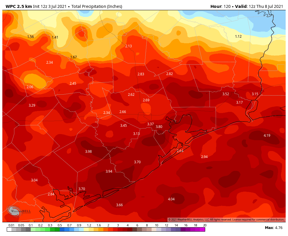
The good news is that, while we expect a fairly wet pattern over the next several days, our concerns about the potential for serious flooding are diminishing. Generally, most of the region should see between 2 and 4 inches between now and Thursday morning, with higher isolated amounts. While this will surely make for a soggy week, it should only produce scattered and sporadic street flooding.
With that said, if you have outdoor plans for the July Fourth holiday weekend you’ll definitely need to keep an eye on the radar, and have a backup. As of 10am CT on Saturday morning, storms are already firing up north of Interstate 10, and these should drop down to the coast later this morning and into the afternoon hours. A good chance of storms will persist through at least the early evening hours. Please do seek shelter during thunderstorms, as we expect to see a fair amount of lightning today. Conditions should be similar on Sunday, although we have some hope that most areas will see rains ending before fireworks shows begin. This rainy, cloudy pattern should persist through about Wednesday.
In the tropics, Elsa has weakened overnight as it has zipped westward across the northern Caribbean Sea. The global models are starting to come into better agreement, and confidence is now fairly high that Elsa will move across Cuba on Sunday, and approach the Florida Keys on Monday. After this time there remains some uncertainty, but generally the storm should track up the western coast of Florida, and may bring heavy rains to the state early next week.
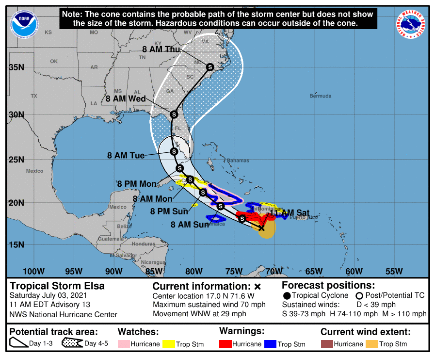
As for intensity, Elsa is now a high-end tropical storm, with maximum sustained winds of 70 mph. Maybe the cold never bothered Elsa anyway, but wind shear has been hampering the storm’s organization overnight, and as it faces additional shear and begins to interact with Cuba, it should weaken further. Elsa’s rapid movement to the west-northwest is not helping either, but the storm should begin to slow down fairly soon. The official forecast has Elsa approaching Florida as a strong tropical storm by around Tuesday of next week, and it would not surprise me if the system is weaker.
Another solid Elsa joke.
Love the Elsa comment!
Guys I hope y’all know y’all’s no hype news is very enjoyable. Thank you guys keep up the great work.
Had to work in the “Frozen” reference!
Do you expect Elsa to move up the coast to New England or head out to the ocean before then? We will be on vacation in New England starting late next week.
LOVE your ‘cold never bothered Elsa anyway’ line – LOL!!! 🙂
Is the wind shear responsible for Elsa’s rapid movement? If not, what is? 29 mph is pretty fast for a tropical storm.
It would be helpful to have your take on potential for extreme heat waves in Houston like what’s happening in the Pacific NW. The Chronicle had a piece by Chris Tomlinson saying it could be 130s here with similar conditions…
We only got 0.14″ today (Saturday) up here in the Champions area. I’m not complaining…