Just a quick post on this Saturday morning to say that we’re still expecting a wet, but not particularly disruptive weekend for the Houston metro area.
As expected, the Gulf of Mexico tropical disturbance has moved inland into the central Texas coast overnight without developing. The strong easterly winds—Galveston briefly saw wind gusts of about 30 mph around midnight—resulting from this system should subside today and tides will slowly come down over the next couple of days.
Otherwise the story of the day will continue to be on-and-off rain showers with the potential for isolated heavy rain showers. I expect most of Houston will see between 0.5 to 1.5 inches of rain today and tonight, with rain chances beginning to slacken by around sunset give or take a few hours.
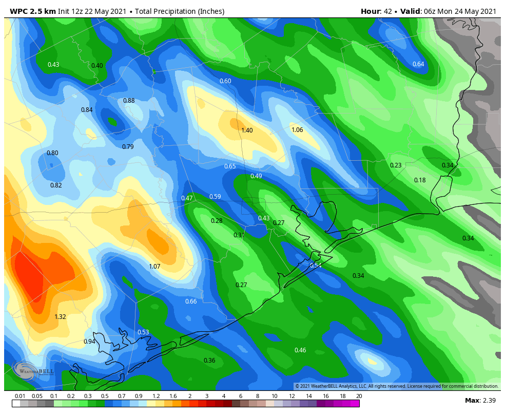
NOAA rain accumulation forecast for now through Sunday night. (Weather Bell)
The potential for heavy rainfall ends after today, but we’ll continue to see a decent chance of showers on Sunday and into early next week. Chances most days will be in the 30 to 40 percent range, with modest accumulations. Beginning on Monday or Tuesday, days should steadily become more sunny, and temperatures will rise from highs of about 80 degrees to the upper 80s by week’s end.
Good morning, Houston. The radar is quiet as the sun begins to rise, but it’s not expected to remain so. We still anticipate a pair of rainy, but not menacing days, before we finally move beyond the persistent threat of rain on Sunday. The Atlantic tropics are also starting to heat up, but again, we don’t see any really significant threat from this. More on the tropics below.
Friday
I’ve had so many questions from readers about the weather for this Friday and Saturday that I know many of you have outdoor activities planned for this weekend. So for those of you with birthday celebrations, graduations, and weddings, I am sorry. The news is not great. It’s gonna rain.
Showers should remain rather scattered this morning, before becoming more widespread this afternoon. We may also see a few stronger thunderstorms that produce some briefly heavy rain. However, these showers should scoot through the area, from southeast to northwest, at a pretty good clip, helping to limit accumulations. Totals for most people today should be on the order of 0.5 inch, with some areas seeing more, some less. Highs today will reach about 80 degrees, with plenty of humidity, and skies will of course be mostly cloudy. Rain chances back off during the evening and overnight hours, with lows only dropping to around 70 degrees.
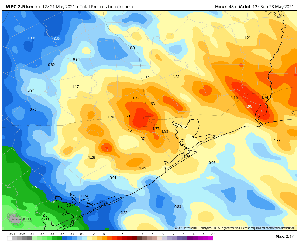
NOAA rain accumulation forecast for now through Saturday. (Weather Bell)
Saturday
We’re not sure when the bulk of the precipitation is going to come on Saturday, whether its largely during the overnight hours into the morning, or whether it’s more of a midday or afternoon thing. What we can generally say is that most areas will probably see about 1 inch of rain, give or take, and the better chances for heavier rainfall will lie west of Interstate 45. The bottom line is that while this rain will put a damper on outdoor activities during the daytime, I think things should begin to clear out during the evening and overnight hours. Highs will again be around 80 degrees.
Sunday
We can’t rule out some light showers again on Sunday, but I think these will primarily occur west of Interstate 45 and should be fleeting. Skies will start out cloudy, but we may see a few flecks of sunshine before the day ends. Highs will again reach about 80 degrees.
Next week
Rain chances won’t be zero next week, but they’ll be in the 20 percent range for most days, with overall very low accumulations. Highs will climb into the mid, and probably upper 80s as skies turn from partly to mostly sunny by mid-week. We might reach the 90s by next weekend.
Tropics
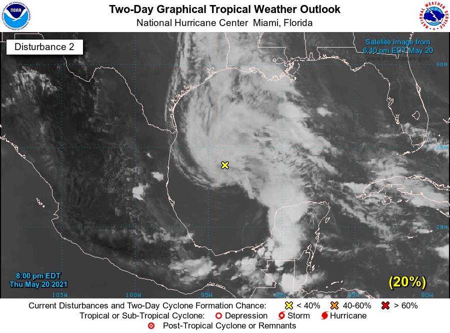
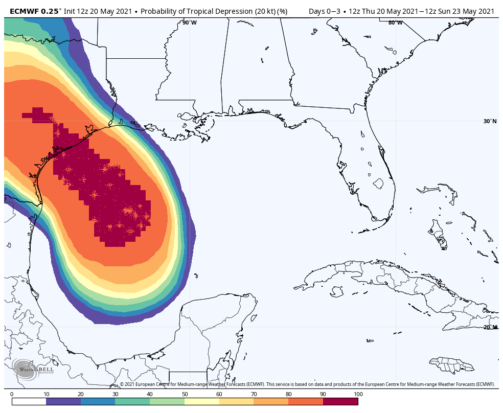
So what’s going on in the tropics? I want to talk about three things. First of all, not much has changed with the Gulf of Mexico disturbance overnight. It’s still there, it’s still disorganized, but it still has a narrow window to develop into a tropical depression as it moves toward the Texas coast. The National Hurricane Center gives the system a 40 percent chance of becoming a depression before moving into Texas tonight. Even so, we don’t think it will change our forecast much. If that changes, we will of course update later today.
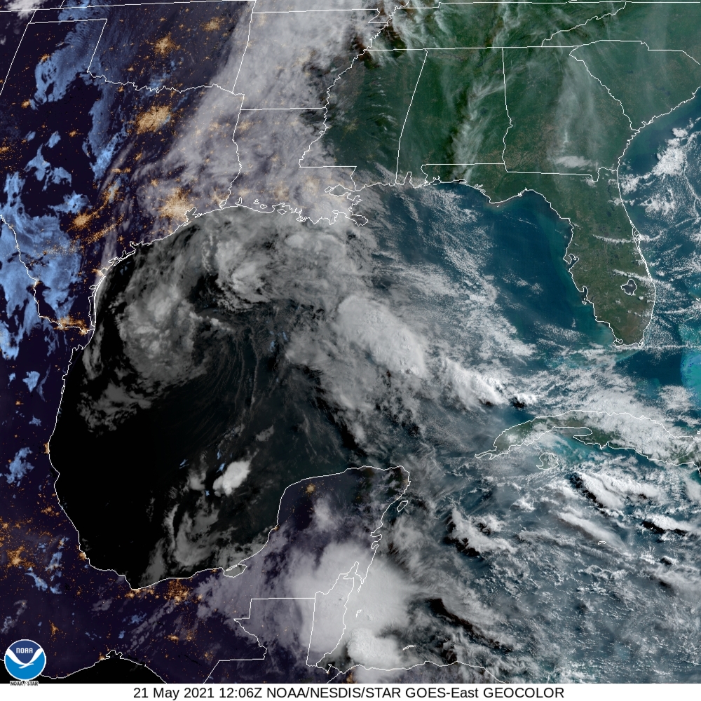
Satellite image of Gulf of Mexico disturbance on Friday morning. (NOAA)
Another system in the open Atlantic is more likely to become a subtropical storm over the next day or two. This one won’t affect land, but would gain the name “Ana,” and become the Atlantic season’s first named storm even though the season doesn’t begin until June 1. A weak storm forming before the official beginning of hurricane season happens fairly regularly, so it’s nothing to get alarmed about.
Finally, NOAA released its Atlantic hurricane outlook on Thursday, and it calls for an “above normal” hurricane season, with 13 to 20 named storms. This is in line with other season predictions, and I just want to reiterate what we wrote in April about all of this.
Seasonal hurricane forecasts are far from perfect. I think, generally, we can expect a busier Atlantic season, but we’re almost certainly not going to see a brute of a year like 2020. Moreover, the chance of the Houston area being directly affected by serious tropical weather (in terms of floods, winds, or surge) is pretty low. Historically, the region only sees a significant storm about once a decade or so. Therefore, while it certainly is time to begin planning for the 2021 Atlantic season, I very much do not want you to start worrying or obsessing about it. Matt and I will, of course, be here every step of the way.
We’ll be back with another post this evening, or Saturday morning, to wrap up the Gulf disturbance situation, and our expectations for rainfall on Sunday.
Throughout today the European forecast model has been advertising the potential for a tropical disturbance to develop in the Gulf of Mexico, and then move toward the Texas coast this weekend. This evening, in its 7pm CT update, the National Hurricane Center gave this system a 20 percent chance of developing into a tropical depression over the next two days.
(National Hurricane Center)
Here’s what we can tell you: this system very likely will not have much impact on our region’s weather. We have already forecast a healthy chance of rainfall on Friday and Saturday along the upper Texas coast, and that will not change. Our expectation is that most of the region from Houston to Beaumont will see an additional 1 to 2 inches of rain through Saturday night, with higher isolated totals. All of this should be manageable despite our recent rainfall.
This Gulf low pressure system, which remains poorly organized this evening, is forecast to track north, and then northwest, likely approaching the Texas coast late on Friday night or Saturday. Although there is the possibility it may organize somewhat, it will also be drawing in somewhat drier air that will limit this.
European model prediction for where a Tropical Depression may form. (Weather Bell)
The bottom line is that yes, we realize no one wants to see a tropical blob in the Gulf of Mexico. However, this one likely carries a minimal threat, and we expect the region to really begin to dry out on Sunday. We’ll have more in the morning.
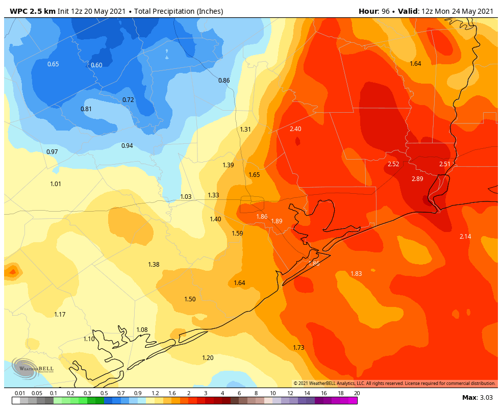
Good morning. The Houston region should see a quiet day today, with scattered showers, before more widespread rain chances return on Friday and Saturday. Overall accumulations, however, should generally remain in the 1 to 4 inch total through Saturday. We therefore are dropping the use of our flood scale as the overall threat diminishes further. It is worth noting that a bit to our east, particularly the Beaumont and Port Arthur areas, could see a bit heavier rainfall this weekend. They were hit much harder earlier this week.
I also want to call attention to a special discussion this afternoon at 3 pm CT, which you can register for here. As part of an event produced by the South Main Alliance, Leroy “Shafe” Shafer, the longtime chief operating officer of the Houston Livestock Show and Rodeo, will interview me. We’ll talk about the origins of Space City Weather, the upcoming hurricane season, and the writing of my book on the early years of SpaceX, Liftoff. The event is free!
Thursday
Our radar is blessedly clear this morning, and we expect only isolated to scattered showers later today. It is possible that the sunshine may peek through for a bit this afternoon or early evening, but skies should remain mostly cloudy. Highs will climb into the low 80s this afternoon, with overnight lows in the low 70s.
Friday
Rainfall should become more widespread beginning early Friday morning, and we’ll see fairly high chances all day. However, these storms should be fairly fast moving, and most areas will likely see less than 1 inch of rain. Highs will be around 80 degrees with mostly cloudy skies. Rain chances will slacken a bit overnight.
Saturday
One final burst of moisture arrives on Saturday, and in the upcoming period this should be the day when our region has its best rain chances. Much of Houston could see around 0.5 to 1.5 inches of rain on Saturday, give or take, with mostly cloudy skies and highs around 80 degrees. This won’t be great for outdoor activities, but at least we do not anticipate any significant flooding from these rains.
NOAA rain accumulation forecast for now through Sunday. (Weather Bell)
Sunday
Rain chances aren’t going to entirely go away on Sunday, but they should drop back quite a bit. We also expect to see at least a modest amount of sunshine during the afternoon hours, although I’m not sure it’s going to get full blown sunny on us. Highs will probably reach the low 80s.
Next week
Skies will turn partly, and then probably mostly sunny next week. This will allow high temperatures to climb into the mid-, or possibly upper-80s by the end of the week. Some slight rain chances will remain each day, but any showers that develop look to be fairly scattered in nature. It’s late May, so you should know better than to inquire about future cold fronts.