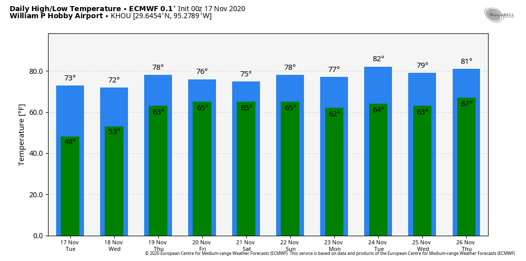
Sorry Houston, no strong front is coming this week

Hi everyone—just a quick Labor Day morning update here.

We’ve got some good news and some bad news, and we’ll start with the latter. If you’ll recall last week, we were 50-50 on whether a fairly robust cool front would push through the region. Alas, we’re now pretty confident it won’t make it. Summer, such as it is in Houston, will continue for awhile longer, albeit with highs mostly in the low 90s rather than the mid- or upper 90s.

The good news is that although we’re on the cusp of two more named storms forming in the Atlantic tropics, continuing this hurricane season’s record pace, we see no threats to the Gulf of Mexico over the next several days at least. This week is the historical peak of hurricane season, and for Texas the threat should be ebbing in about three or four weeks.

As for our weather this week, Labor Day will see a fair amount of sunshine and highs warming into the mid-90s. With slightly weaker high pressure over the region, some slow-moving showers and thunderstorms could produce 1 or more inches of rainfall today, but things will again be hit or miss. Tuesday should be similar.

The cold front is going to get hung up in Central Texas on Thursday. (Weather Bell)

The latter half of the week will be influenced by a cold front dropping into Texas and approaching our region. However, with the front likely stalling out around the Interstate 35 corridor, we only expect very slight effects locally. For now we’ll go with highs in the low 90s, and with lows dropping into the mid-70s, and a smattering of rain chances.

We’ll be back tomorrow with a full update!

Two questions: Will it rain this weekend, and will the front really make it?

The watchword for Houston’s weather in the coming days is uncertainty—with the main questions concerning whether it will rain locally over the next few days, and whether a front will push through Houston on Wednesday or so of next week.

Thursday

It’s going to be another very warm day along the coast, with highs in the 90s and heat indices pushing into the low 100s. High temperatures elsewhere will likely get into the mid-90s, tempered somewhat by more clouds in the sky. Forecast models are pretty inconsistent, but given the available moisture in the atmosphere I’d guess about one-third of the area sees some form of light to moderate precipitation later today. This should help moderate temperatures slightly.

Here is NOAA’s rainfall forecast for now through Saturday. Calibrate your expectations accordingly. (Pivotal Weather)

Friday and Saturday

By Friday, a nearby upper-level system in conjunction with a weaker capping inversion should increase coverage of rain showers and thunderstorms to 40 or 50 percent. These will most likely occur later during the afternoon hours, with the peak of daytime heating. I still think skies will be at least partly sunny, and we can probably expect highs to get into the mid-90s. Overnight lows will remain sticky and warm, in the upper 70s except immediately along the coast.

Sunday and Labor Day

The second half of Labor Day weekend will likely see more sunshine as high pressure amplifies a bit. Expect a pair of warm, summer days with plenty of sunshine and highs in the mid- or upper-90s. We’re not going to rule out some scattered showers along the sea breeze, however.

European model 500mb forecast for Monday. (Weather Bell)

Will the front make it?

Oh, my friends. I would love nothing more than to tell you that fall’s first cold front will definitely come barreling into Houston six days from now. But the fact of the matter is that this possibility hinges the strength of a ridge of high pressure near Canada and Alaska early next week, and the extent to which a trough of cooler air can penetrate into the central United States. Right now the models are parsing a pretty fine line on whether that happens or not to allow cooler air to make its way all the way down to us—so we’re sticking to our 50-50 prediction of whether a front makes it.

Houston’s very hot weather will begin to ease in the coming days

Good morning. The main story of our weather continues to be heat—Houston’s high temperatures for most of the last week have reached 99 degrees or above—but after today our hottest weather and extreme heat indices should be in the rear view mirror. We expect to see a few more clouds today, and then better rain chances starting tomorrow should help to temper our peak daytime heating just a bit.

Wednesday

A large complex of storms that has produced several inches of rainfall over North Texas should continue to sag southward this morning. But most likely these storms will stall out to the northwest of our area—the rains will probably reach a line from Sealy to Conroe before dying out. Areas northwest and along this line may see some additional on and off rainfall through this evening. Otherwise it should be a partly to mostly sunny day for most of the metro area, with high temperatures in the mid- to upper-90s. Winds will again blow from the south, gusting perhaps to 20 mph due to a tight pressure gradient.

On Wednesday and Thursday the heaviest rains should remain northwest of Houston. (Pivotal Weather)

Thursday

As more moisture moves into the atmosphere we’re likely to see more clouds on Thursday, and this should help to moderate temperatures slightly. At least some scattered showers will be possible as highs get into the low- to mid-90s. Nighttime lows will remain sticky, in the upper 70s.

Friday

A bit more of a disturbed atmosphere on Friday, in conjunction with ample moisture in the atmosphere, should lead to more widespread showers on Friday. Accumulations will likely vary widely across the region. Highs will depend upon the extent of rainfall at your location.

Saturday, Sunday, and Labor Day

The weekend weather looks fairly standard for this time of year, with partly to mostly sunny skies and highs in the low- to mid-90s most likely. We’ll have some decent rain chances—perhaps 30 percent?–each day along the sea breeze.

Sunday and Monday of Labor Day weekend should see plenty of sunshine across the metro area. (Weather Bell)

Next week

We’re still watching the potential for a fairly robust cool front to arrive in Houston later on Tuesday or Wednesday of next week. If it makes it, this front will provide a nice shot of drier and cooler air, but it remains too close to call or guarantee a week out.

Laura wrap-up

As some of you may know, for my day job I write for a publication called Ars Technica. On Tuesday, we published a feature on Hurricane Laura, and the very close call on whether the region enacted a more widespread evacuation. And it was very close.

We’ve survived August—if only barely

Well, we made it. August has ended. You may recall at the outset of this month I wrote that August was a month to survive in Houston: “If you’re in Houston in August and the high temperature is not in the upper 90s or higher, the streets aren’t flooding, and you’re not concerned about an impending hurricane—it’s a win.” Alas we didn’t do much winning in August. The daily high temperature was 98 degrees or higher on 15 days last month, and we spent about 10 days worrying about an impending hurricane. So August was August, and now, at least, it’s over.

It’s going to be very hot again on Tuesday in Houston. (Pivotal Weather)

Tuesday

September won’t bring immediate change to Houston in terms of temperatures, but we do still expect a pattern shift in about nine or 10 days time. Alas, Houston will remain under a heat advisory on Tuesday, with high temperatures in the upper-90s across much of the region and sultry humidity pushing the heat index to 110 degrees or higher for much of the region. Skies will be mostly sunny. Let’s be honest, this is pretty oppressive weather—the only very slight relief will come from a southerly breeze, which may at times gust above 20 mph. Rain chances are near zero.

Wednesday and Thursday

For now we’ll go with continued hot and mostly sunny weather for these days, and additional heat advisories will probably be warranted for the Houston metro area. The one wrinkle is that an upper-level low pressure system and a cold front over North Texas may help spur a few showers in Houston, but for now I think we’ll remain dry. The best bet is on continued heat and sunshine. We do have some concerns for the Dallas-Fort Worth metro area and this system, as it could bring 6 inches of rain or more through Thursday, which may lead to some localized flooding in central and northern Texas between now and Thursday.

Friday, Saturday, and Sunday

The forecast for the weekend remains a bit uncertain as some tropical moisture may move in from the Gulf of Mexico. This may elevate rain chances to on the order of about 30 percent each day, but for the most part I expect Houston to remain hot, in the mid-90s, and partly to mostly sunny. We’ll try to pin this forecast down in the next day or so.

Yes, the front is still there in both the GFS (shown) and European models. (Weather Bell)

Next week

We’re still looking at the possibility of a pretty decent cold front by Wednesday or so of next week. We are making no promises—early season fronts often fail to materialize—but this feature remains fairly consistent within the models. If it happens, we can probably expect a nice shot of rainfall, before drier and cooler air moves in. Should the front happen, it probably would bring a couple of days of highs in the 80s, with lows in the 60s. So, fingers crossed, Houston. All of them.