Good morning. This post will focus on Tropical Depression 8, because after today it will strongly influence our region’s weather through the weekend. Overall, our forecast for this tropical system has not changed a whole lot from yesterday: We are predicting a Stage 2 flood event for coastal counties (plus southeastern Harris County), and a Stage 1 event for inland areas of the Houston region. In short, for most, this probably will be a wet weekend, but not a wholly disruptive one. But as always with tropical weather we’re going to watch this one closely.
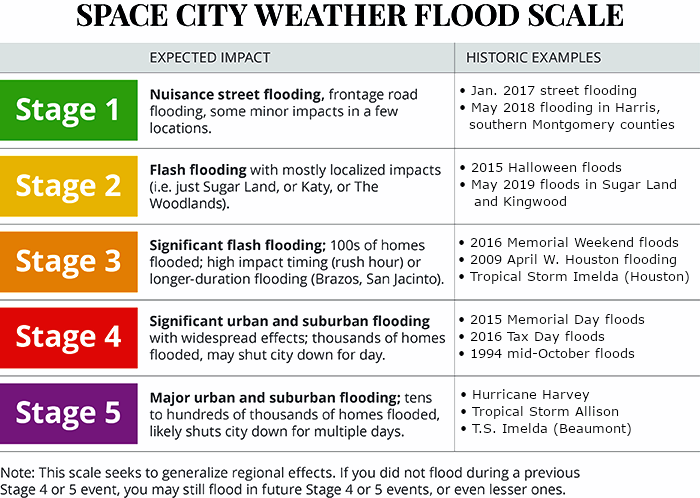
Space City Weather flood scale.
Thursday
After several wet days, with parts of the area such as Clear Lake and Pasadena picking up 5 to 7 inches of rainfall, today should bring partly sunny skies and some time to dry out swampy yards. Rain chances are probably below 20 percent for most, with warm afternoon sunshine helping to dry soils out and pushing highs into the mid-90s. This will be hottest day until at least early next week. Winds will be light, out of the east to northeast.
Friday
The forecast for Friday morning is similar, with low chances of rain through at least the morning hours and perhaps into the afternoon as well. However, starting around sunrise or shortly thereafter, we’re likely to see winds pick up out of the east to northeast at about 15 mph. Rain chances pick up during the evening and overnight hours as the outer bands of the tropical system reach our area. After that, our weather is largely dependent upon the tropical system’s track and the vagaries of its structure.
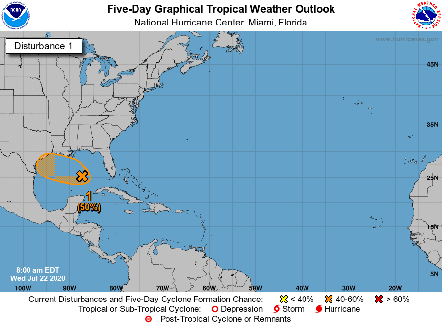
This afternoon we’re issuing our first “flood scale” forecast for the Gulf disturbance, which is increasingly likely to move into Texas this weekend as a tropical depression or weak tropical storm. We are calling for a “Stage 2” flood event for coastal counties in the greater Houston area—Brazoria, Galveston, and Chambers as well as southeastern Harris County (i.e. the Clear Lake area). For inland areas we think this will be a Stage 1 event. As with all tropical weather, of course, this forecast is subject to change. (Read more about the scale, and why we created it).
Space City Weather flood scale.
Now let’s explain how we came to this forecast.
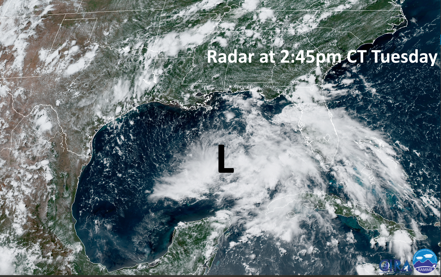
Satellite appearance
Let’s begin with the system itself, which at present is about due south of the border between Alabama and Mississippi, and moving nearly due west. The storm’s organization has improved today, adding westerly winds, which is a precursor to developing an overall circulation. Trends favor additional organization and we probably will see this named a depression or Tropical Storm Hanna later today or on Thursday. We expected this, but do not anticipate further strengthening to, say, a hurricane. Theoretically this is possible, but does not seem likely given the storm’s interaction with dry air, among other factors.
Gulf disturbance satellite presentation on Tuesday afternoon. (NOAA)
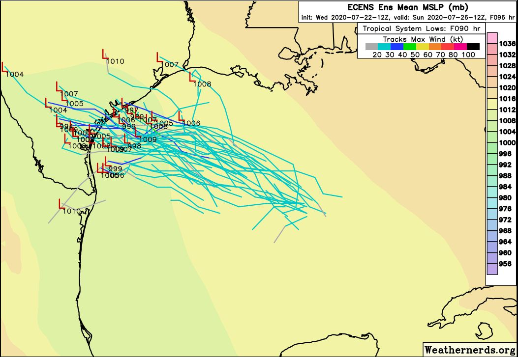
Track
The storm increasingly seems likely to move toward the central or southern Texas coast. The preponderance of ensemble members of the European and GFS models predict such a track. Certainly, without a well established center of low pressure it is important to not give too much credence to these predictions. But as we are perhaps just two or three days away from a Texas landfall, and there is good consistency in the track forecast, our confidence level in the track is moderate.
12z European model forecast tracks for the Gulf disturbance. (Weathernerds)
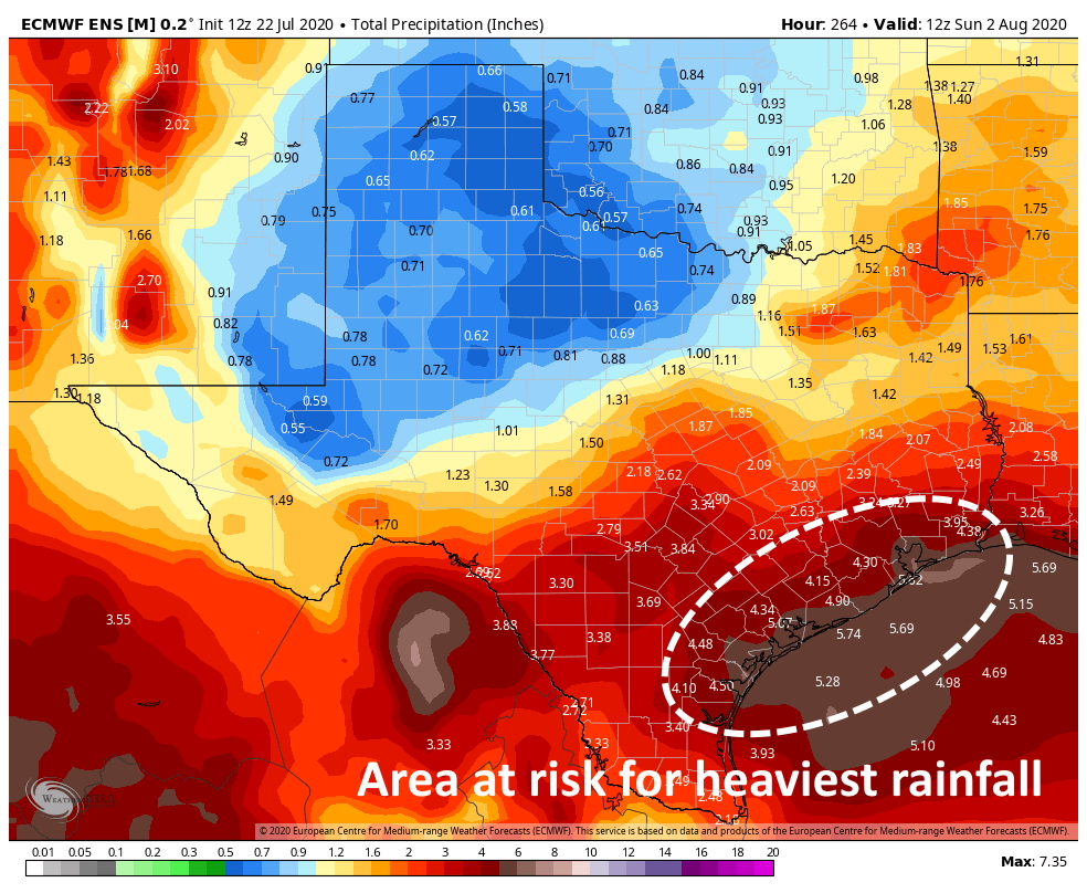
Rainfall
Unfortunately, knowing the track of a tropical system does not confer meteorological superpowers when it comes to trying to forecast rainfall totals. We believe the heaviest rains will be to the north of the storm’s center, but the “where” is difficult to say.
Some of the forecasting models we commonly use are starting to predict rainfall “bullseyes” of 10 inches for hardest hit areas, particularly along the coast. (This seems pretty reasonable for a tropical system like this). However, we do not have confidence in whether these highest totals will come in Corpus Christi, Galveston, or Port Arthur. It is because of this potential for 10 inches of rain in the Houston area that we are issuing a Stage 2 warning for coastal areas. We still think much of the greater Houston region will see 2 to 4 inches of rain over a couple of days, which is totally manageable.
European model ensemble forecast for average precipitation from the Gulf system. (Weather Bell)
Beyond this system
The National Hurricane Center may upgrade Tropical Storm Gonzalo to hurricane status tomorrow as it approaches the southern Caribbean Sea. Right now we have relatively low concerns about Gonzalo becoming a threat to the Gulf of Mexico. We will of course continue to watch it, but advise you to not lose any sleep over it. Beyond Gonzalo the tropics are going to remain active.
Good morning. Houston will remain in a very wet pattern through the weekend, highlighted by the arrival of moisture from a tropical disturbance—possibly a tropical storm by then—on Friday. This should lead to elevated rain chances through the weekend, especially for coastal areas. We’ll discuss this in greater detail below.
All eyes on a Gulf disturbance for Texas. (National Hurricane Center)
Wednesday
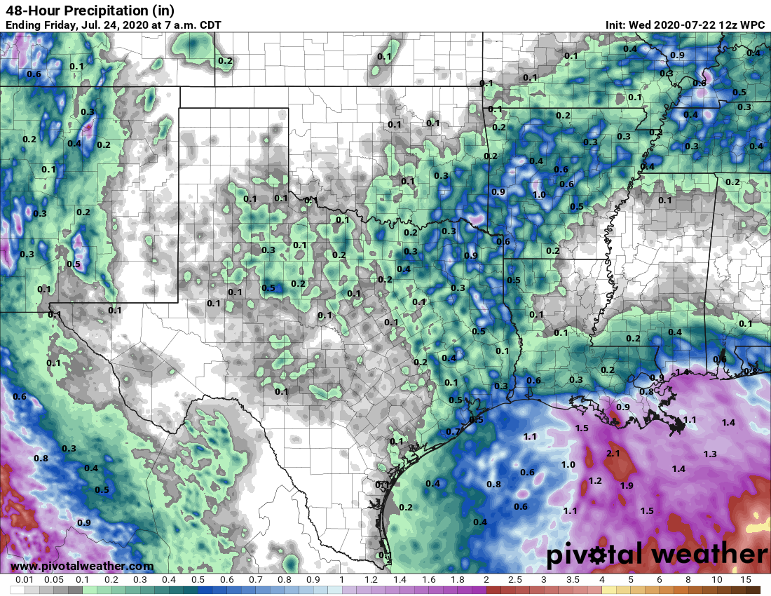
The radar is mostly quiet this morning, with the exception of northward moving storms near Baytown and Channelview. With tropical moisture pushing in from the coast, we expect more widespread storms to develop this afternoon. For the most part accumulations should be less than one-half inch but a few areas may see higher bullseyes—such is the nature of tropical rainfall. Skies should remain partly to mostly cloudy today, limiting highs to around 90 degrees, with light southeasterly winds. This evening and overnight hours should be mostly rain free, although we can’t rule out a few stray showers.
We anticipate moderate rainfall totals through Thursday for Houston. (Pivotal Weather)
Thursday
We probably will see a brief reprieve from widespread showers on Thursday as some drier air mixes into the atmosphere. At the surface, conditions will still be plenty humid, however, and combined with partly sunny skies we should see daytime temperatures rise into the mid-90s. These afternoon highs, in turn, could trigger a few afternoon showers, but most of us should remain dry.
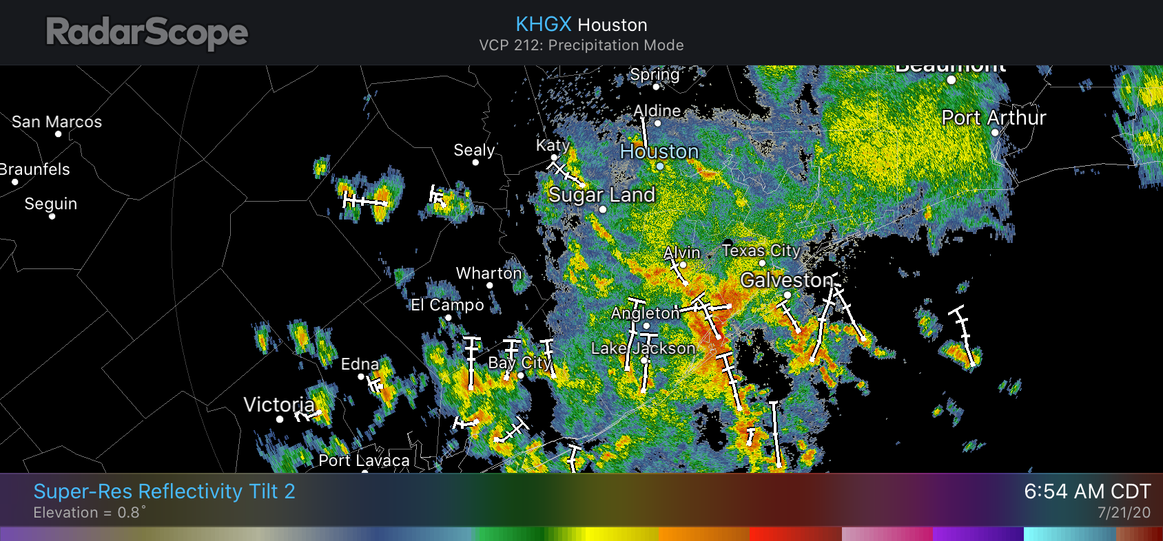
Good morning. For some areas south of town it has been a wild and woolly night, with near-constant thunder and lightning. Some parts of League City and Dickinson received 4 or more inches of rainfall since around 2 a.m., while areas north and west of Houston have received nary a sprinkle. This fairly wet pattern should remain in effect through Saturday, or possibly even Sunday as another tropical wave approaches the coast on Friday. This wave has a pretty decent chance of becoming a tropical depression.
Storms are lighting up the coast at around sunrise on Tuesday. (RadarScope)
Tuesday
Showers along the coast should move inland and westward later today before fading out this afternoon or early evening. Most of the area probably will receive 0.5 to 1.5 inch of rain, but as we’ve seen in southern parts of the region overnight, some locations may sit under slow-moving storms and receive more. So far rainfall rates have generally been under 1 inch per hour, which has prevented any significant flooding. Cloudy skies and rains should help limit high temperatures today to about 90 degrees. Any storms that develop Tuesday night should be of a more scattered, and less concentrated nature.
Wednesday
The atmosphere on Wednesday should allow for another healthy chance of showers, but we don’t anticipate them being as intense or widespread as storms on Tuesday. Highs will again be limited to about 90 degrees with mostly cloudy skies and rain to help cool surface temperatures.