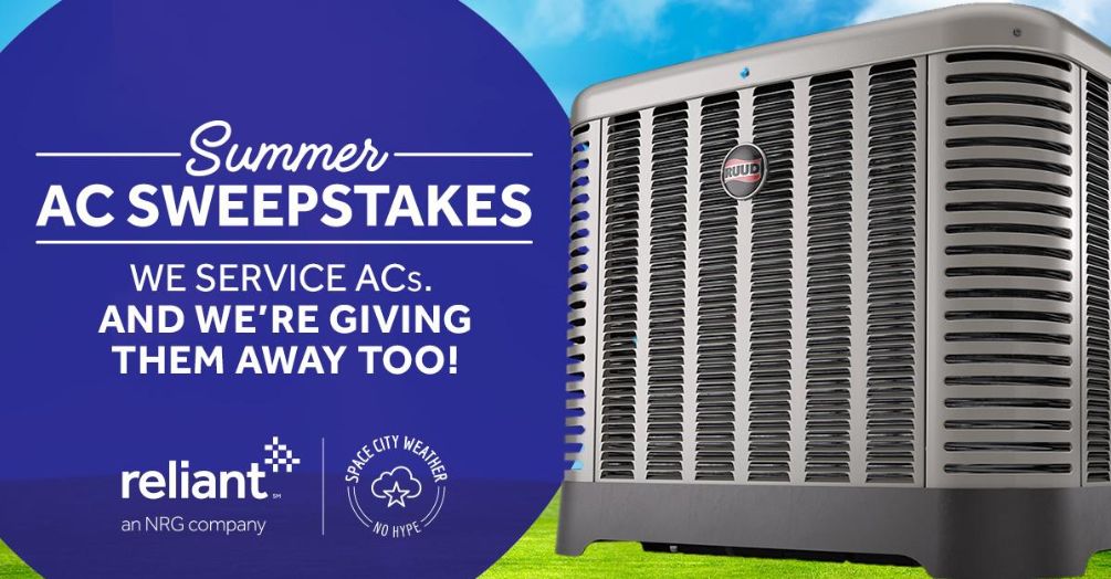
Dry now, a bit soupy to end the week in Houston

The first three weeks of January saw an average temperature about 7 degrees below normal across Houston, but the last week of the month should see weather more typical for this time of year—which is to say not too hot and not too cold.

Tuesday, Wednesday, and Thursday

After a chilly start this morning generally in the 30s across Houston, pleasant winter weather awaits. Under the influence of high pressure, we’re going to see mostly sunny days with high temperatures in the low 60s, dry air, and cool nights with lows in the low 40s—warmer at night along the coast and cooler for inland areas. Clear skies should make for really nice sunrises and sunsets.

Thursday night, Friday and Saturday

By later on Thursday, an onshore flow should resume, and this will increase cloud cover and return some rain chances to the area. Basically, the combination of warm, and moist air will generate some light, probably mostly misty rainfall later on Friday, Friday night, and Saturday across the area. In terms of accumulation, we’re probably talking at most a tenth of an inch of rain, or two.

NOAA’s rain accumulation forecast through Saturday night shows only modest amounts for Houston. (Pivotal Weather)

Despite the mostly cloudy skies, due to warm air moving back in from the coast we’ll see highs near 70 on Friday, and probably at or above 70 on Saturday. The rain won’t be continuous, and some areas probably won’t get wet, but it won’t be the best start to the weekend.

Sunday

A cold front will push into Houston this weekend, and right now the most likely time seems to be between midnight and sunrise on Sunday, although this timing remains subject to some change. Most likely we’ll see a fast-moving, broken line of showers with the front. Conditions don’t look too blustery in the wake of the front’s passage, with perhaps 10- to 15-mph winds on Sunday as cooler air moves in to limit highs into the 60s. Sunny skies should return quickly, too. There’s some question about the strength of the front, but I suspect there will be enough cooler air to keep us in the 60s (highs) and 40s (lows) regime for the first half of next week. Rain chances fall off with the front’s passage, too.

Splendid January weather for Houston this week, mostly

After four weeks of often-times very cold weather, high temperatures on Sunday broke into the 70s on Sunday. According to the National Weather Service, that is the 5th longest streak on record of sub-70 degree days for Houston’s Hobby Airport, and 12th longest for the city of Houston overall. The last time this occurred was 2010. Certainly, it represented the depth of winter for the region this year.

(National Weather Service)

Monday

A cool front moved through Houston early on Monday, generally bringing from one-tenth to one-half inch of rain to the area. Skies will clear out this morning, and we’re going to have an exceptional day with high temperatures of about 70 degrees. Overnight lows will drop to around 40 for inland areas, and 50 degrees along the coast.

Tuesday, Wednesday, and Thursday

Drier, mostly sunny weather will persist through much of the week as high pressure settles over the region. Days will be pleasant, with highs somewhere in the mid-60s, and overnight lows again around 40 degrees for inland areas, and 50 along the coast. Our modest northerly winds will shift from the north to east, and then southeast by Thursday, which should allow humidity levels to gradually rise.

See full post

Does a cold winter in Houston portend a cooler summer?

Yesterday I received several questions on Twitter, Facebook, and during a radio appearance about what this very cold start to 2018—temperatures are about 8 degrees below normal, and we have now had eight nights with lows in the 20s—portends for the rest of the year. For example, does a cold start to the year give us momentum for a cooler-than-normal summer? Alas, the answer is almost certainly no. Historically, there is little connection between winter weather and the subsequent summer. In fact, I’d offer the year 2011 as a counterpoint to this notion. During that year we had an especially cold start to February. Here’s a climate graphic from that month:

February, 2011, climate graph for Houston. (National Weather Service)

Note the frigid temperatures in the first half of the month, with nine nights in the 20s at Bush Intercontinental Airport, including five at 25 degrees or below. These are all hard freezes. A lot of you will remember the rest of the story, as 2011 ended up being the city’s hottest year on record at the time. August was especially brutal, with all but one of the days that month reaching 100 degrees.

August, 2011 temperature graph. (National Weather Service)

All of those stars in the graph above are record high temperatures. It was an absolutely brutal month. Let’s hope we’re not bound for similar weather this year.

See full post

Houston just had its coldest night since 1996

It’s an icebox out there, folks. After Tuesday night’s precipitation, skies cleared out from north to south, and shortly after midnight many areas saw stars. This, in conjunction with very cold Arctic air, brought the low in Huntsville down to 13 degrees this morning, as of 7am CT. Most of central Houston saw temperatures from 18 to 20 degrees. Even Galveston, our balmy, tropical Galveston with its lovely palm trees, fell to 25 degrees. The following map shows temperatures across Texas this morning.

Wednesday temperatures at 7am CT. (Weather.us)

It does not appear as though Houston will set a record low temperature for today (which is 15 degrees, set in 1930). However, this is the coldest it has been in the city since January, 1996, and the region has not registered a colder temperature since Dec. 24, 1989.

Wednesday

Area roadways remain a mess. Although some roads have dried out from Tuesday’s precipitation, ice remains a problem across the city—mostly on bridges and overpasses. As of 7am, Houston Transtar reports 137 areas of ice on roadways, and these are only the major thoroughfares. Sunny skies today will help the process of sublimating ice on roads, and by noon temperatures should reach above freezing for most of the metro area. Until then, travel will be dicey through the area. Check your route before you leave home. By this afternoon roads should be clear.

Highs today will reach the mid- to upper 30s before another cold night with lows around 20 north of the city, in the mid-20s in Houston, and near freezing along the coast.

See full post