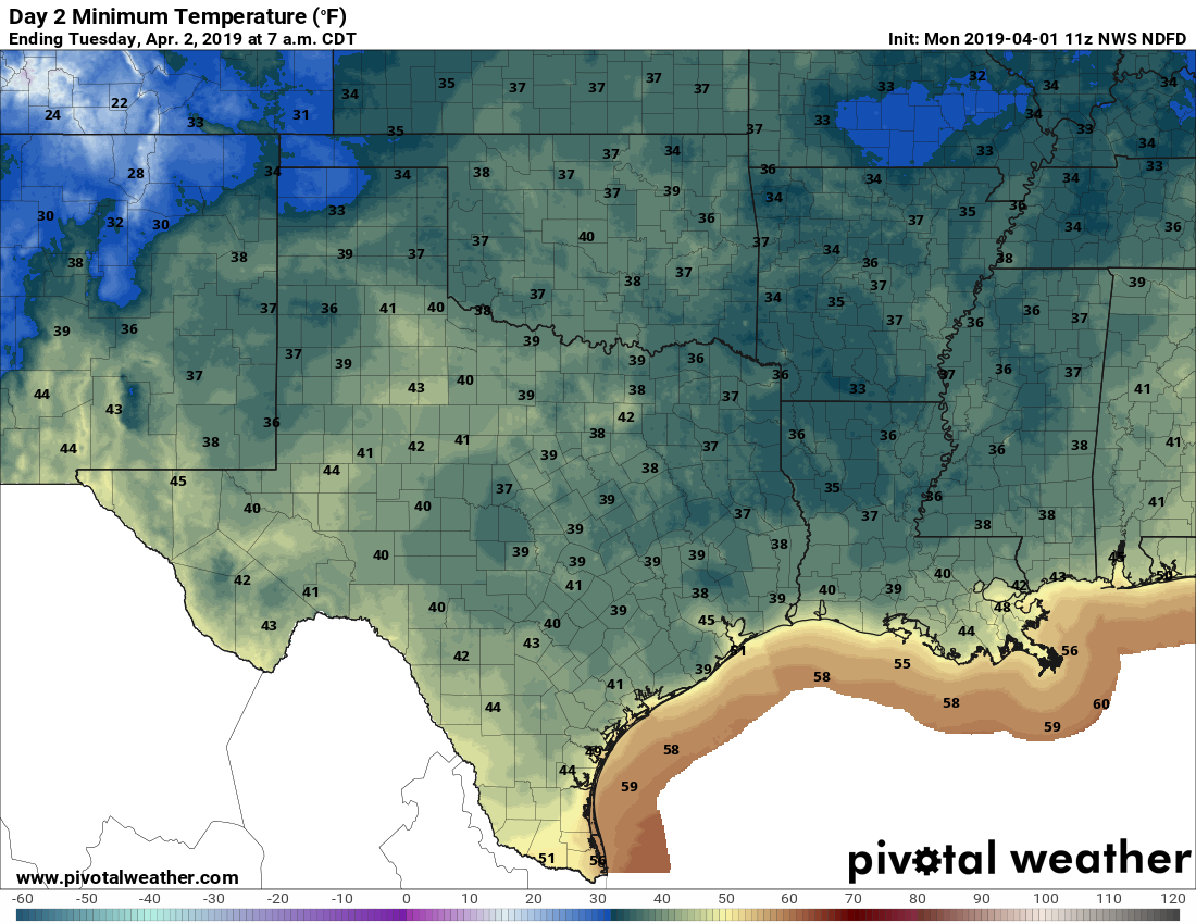
High pressure not quite as dominant this week over Houston

Parts of Houston experienced storms on Sunday evening as convection fired along a boundary, and moved from east to west. It was feast or famine—areas near downtown received 1 inch of rain quickly, while areas northwest and southeast of Houston got no rain at all. The good news is that, unlike last week, we will have some scattered rain chances this week as high pressure it not full able to assert itself over the region’s weather.

High pressure (redder colors) won’t be quite as dominant over the Texas coast this week. (Weather Bell)

Monday

Rain chances will remain today, especially for the northern half of the area, as moisture levels remain high and the atmosphere is somewhat unstable. Like Sunday, the storms should be most prevalent during the afternoon and evening hours with daytime heating, and they’re probably going to be hit-or-miss again. In addition to briefly heavy rainfall, we’re also going to need to watch for damaging winds and perhaps a little hail. One thing we’re sure not to miss out on is heat and humidity, with highs in the mid-90s for the most part.

See full post

Scattered, strong storms possible later Sunday

It’s sunny and hot out there on Sunday afternoon, but an approaching (weak) front should provoke some scattered showers and thunderstorms later this afternoon and evening. We think a lot of the region won’t see more than some clouds, but for the parts of the region that do see storms they could be strong, with some brief heavy rain and winds.

Severe storm outlook for Sunday and Sunday night. (NOAA)

Storms are most likely to form north of Interstate 10 later today as the precipitating front is presently only sagging into counties north of Houston. Most of the higher-resolution forecast models aren’t overly bullish on storms, however moisture levels are high enough, and there’s potentially enough instability, that the environment seems right for at least a few thunderstorms to develop.

The bottom line is that if you see storms forming nearby, it’s best to take cover if possible. They probably won’t last long.

Sunday’s chance of rain isn’t good, but it’s all we’ve got

The heat will continue as high pressure remains more or less in control of Houston’s weather. Why? High pressure occurs when air above sinks downward—this increasing the pressure of the atmosphere at the surface. This descending air generally inhibits the formation of clouds, and very often prevents moist air at the surface from rising, and returning as precipitation. So hot, and sunny.

High pressure (deeper reds) will dominate our weather through Saturday. (Weather Bell)

Thursday, Friday, and Saturday

And this is just what we’re going to get for awhile—hot and mostly sunny, with highs in the mid-90s for the most part. Warm nights in the mid- to upper-70s. Not much more to say as high pressure dominates our weather.

See full post

Houston likely to record its third warmest May this month

The month of May is about to draw to a close, and it has been a warm one for Houston. Through Tuesday, the average temperature for the month at the city’s official weather station, Bush Intercontinental Airport, is 79.6 degrees Fahrenheit, which is 3.0 degrees above normal. (We’ve had just two days this month with below normal temperatures). It appears as though this May will end up as the third warmest May on record in Houston, ranking behind only 1996 and 2010. That may or may not be significant—the summer of 1996 did not end up being abnormally warm, but 2010 certainly did.

Wednesday and Thursday

Our July-in-May weather will continue to wrap up the month, with high pressure building over the region and keeping daytime highs in the low- to mid-90s. Some scattered afternoon clouds may help with temperatures just a wee bit, but it’s still going to be extremely warm out there so please take precautions.

NDFD high temperature forecast for Friday. (Weather Bell)

Friday and Saturday

As high pressure dominates, the story across Texas will be heat. The National Weather Service gridded forecasts are absolutely brutal on Friday, with highs of up to 110 degrees in some parts of the state. This is deep summer weather for Texas to start the month of June—and typically summer doesn’t peak until late July or August.

See full post