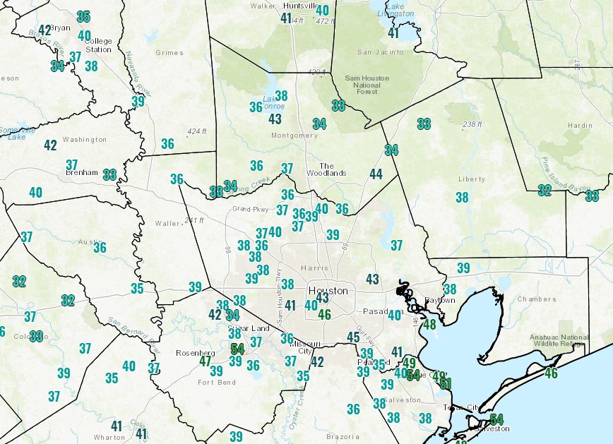
It’s another very cold morning for early April, with temperatures in the 30s for much of the metro area away from the coast. The low at Bush Intercontinental Airport dropped to 37 degrees this morning, which breaks the record low temperature for this day (38 degrees) set in 1996. This has been the region’s strongest April cold front in at least 20 years, although it can’t rival 1973, when a freeze was recorded in Houston as late as April 10. Anyway, after this morning, we’re done with very cold nights like this not just for now, but probably until November.
Tuesday
After the cold start, we’re in for a gorgeous day. Expect full sunshine, with highs around 70 degrees, dry air, and light winds. In short, today should be nigh on perfect. Lows tonight will fall down to around 50 north of Houston, with mid- to upper 50s along the coast. For my tastes, I could not draw up a more perfect day.
Wednesday
By Tuesday night or Wednesday morning, the onshore flow will resume, and we can expect increasing clouds. While we can’t rule out some rain, chances are 20 percent, or less. Highs will be in the low 70s. Overnight temperatures Wednesday night aren’t likely to fall below the mid-60s.

Thursday
With the combination of the onshore flow pumping up moisture levels, and an atmospheric disturbance moving overhead, we’ll see better rain chances on Thursday, most likely during the day. Forecast models remain all over the place, but I expect most of the region to get between 0 and 0.5 inches, with greater accumulations possible to the east, over areas such as Beaumont. Highs will get into the 80s, likely, despite the clouds.
Friday
This has the look of a fairly nice spring day, with partly sunny skies, a bit drier air, and highs in the low 80s.
Saturday and Sunday
Although the forecast is far from locked in, this weekend does look wet in Houston, particularly Saturday afternoon and Saturday night, although it is too early to have much confidence in timing. It looks like most of the area will get a solid 1 to 2 inches of rain this weekend as another atmospheric disturbance moves through. Highs of 80 degrees, or even warmer, are possible both days as we see some breaks in the clouds. We’ll try to pin down the weekend forecast in greater detail in tomorrow’s post.
The region is likely to stay warm, in the 80s, until a moderate cool front moves through, perhaps around Tuesday or Wednesday of next week.
A few days ago I asked a question but not sure if I got a response. Where would I look for that?
Just re-ask the question, I’ll be sure and look for it.
Thanks for the update. So grateful for the extended winter before I begin melting during the long Texas summer (which seems to be half the year!).
Rain chances for Friday night’s Astros home opener ?
🙂 Beware the Ides of “Ughust” 🙂
Eric –
Thanks for the great weather – any chance you could keep it this way until October? Just asking. Don’t think I can keep my sanity through another summer here. Hard enough here in the winter.
The temperature here didn’t get below mid 40s so the airport must have been a cold spot last night. This was definitely the Easter snap. When will the winds stop? I have to re-scan my TV channels and the reception is not good when there is a lot of wind.
Can you take a closer look at the weekend forecast? One tv station calling for bad weather especially on Saturday.
Looking at the temp map above, it looks like a 10-degree swing between the loop (46) and Missouri City/Sugarland (36). That seems significant within a fairly short distance. What causes that?
I was noticing the same thing, too, that Heather just asked in her question. In Rosenberg there was an 8-degree swing in two readings that were right next to each other (47/39).
A lot of that is probably due to the urban heat island effect.
It was a beautiful Tuesday but sadly an ozone action day so no outdoor play for us this afternoon. Why did this happen when it wasn’t hot at all?