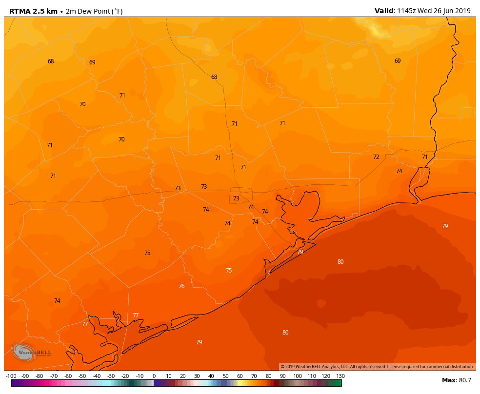
Stormy day on tap for Houston, especially north of the city

Good morning. It’s going to be a stormy day for parts of the metro region, so let’s get right to it.

This morning

A number of showers and thunderstorms have developed along a warm front that’s moved in from the coast, and this will serve as a focus of showers and thunderstorms during the morning hours for the Houston area. These storms are developing primarily to the north of Interstate 10 (along the warm front) and bringing some heavy rainfall and severe weather to Waller and Montgomery counties, and points north.

Houston radar as of 7:10am CT showing storms north of I-10. (Intellicast)

The biggest concern is instability and rotation in the atmosphere, which is favorable for the development of tornadoes. Several tornado warnings have already been issued this morning—and a tornado watch is in effect through 1pm for the northern half of the Houston metro area, as well as much of central Texas.

Area of tornado watch in effect until 1pm CT. (National Weather Service)

It is possible that most areas south of, and along Interstate 10 don’t see much rainfall this morning.

This afternoon

Meanwhile, a large cluster of storms has developed across west Texas and is now (6:55am CT) moving eastward toward Interstate 35. These storms have formed along a cold front, and this mess will move into the Houston area this afternoon. Again, it seems likely the dynamics for severe weather and heavy rains will be most favorable north of Interstate 10 later today, but we’re going to have to watch the evolution of the system closely.

We’ll update again later this morning.

Posted at 7:05am CT on Sunday by Eric

(Space City Weather is sponsored this month by The Mole, a Jonathon Price novel.)

Severe weather is likely on Sunday in or near Houston

We’ve been tracking the possibility of heavy rain and severe storms on Sunday for several days now, and unfortunately the forecast remains on target. If anything, the outlook is worse for Sunday than it’s been.

NOAA’s Storm Prediction Center issued an updated “severe weather outlook” for Sunday, and the entire Houston metro area now lies under a “moderate” risk, the fourth highest category out of five. According to Jeff Lindner, a meteorologist with the Harris County Flood Control District, the severe storm warning level has not been that high for Houston since February, 2008.

Severe weather outlook for Sunday in Houston. (NOAA)

A combination of a potent upper level storm system, moisture moving in from the Gulf of Mexico, and the potential for supercell development will set the stage for storms on Sunday, some of which may become severe.

(Space City Weather is sponsored this month by The Mole, a Jonathon Price novel.)

Forecast models still aren’t in agreement about whether chances for severe storms will begin around sunrise on Sunday, or hold off until the early afternoon hours for most of the Houston area. There also remains some uncertainty about whether the best setup will occur over Houston, or to the northwest of the metro area, between Austin and Lufkin. But tomorrow will definitely be a day to pay attention to forecasts (we’ll be covering), real-time conditions, and official warnings issued by the National Weather Service. We’re concerned about tornadoes—some of which may be more severe than the EF-0 and EF-1 the Houston area typically gets—large hail, and damaging winds.

Heavy rainfall is also a secondary threat, with most of the area likely picking up between 1 and 3 inches, and higher isolated amounts. In short—a mess.

Posted at 9:15am CT on Saturday by Eric

Pleasant today in Houston, but heavy rains and storms likely return Sunday

A cool front moved into the Houston area during the overnight hours, and this will bring us a brief spell of slightly cooler air before conditions warm up again this weekend. We’ll also have to watch for the return of storms and widespread, heavy rain on Sunday.

Today

Winds are blowing out of the northwest this morning, and could gust up to about 20mph later today. Even after skies clear out we should expect high temperatures only to rise into the upper 70s today—alas there won’t be too many days this cool again until late next fall. Lows tonight should fall into the upper 50s for the northern half of the Houston area, and to around 60 degrees closer to the coast. Enjoy the drier air.

Friday

After a cooler start on Friday morning, conditions will quickly warm under mostly sunny skies. Look for high temperatures in the mid-80s across Houston. I think some areas further inland, such as College Station, could see highs in the upper 80s although I don’t think they’ll quite make 90 degrees. Lows Friday night will be 5 to 7 degrees warmer than Thursday.

(Space City Weather is sponsored this month by an anonymous donor)

See full post

Strong thunderstorms moving into Houston Wednesday morning

Good morning. The big concern today is a line of strong thunderstorms moving into metro Houston this morning from the west. As of about 6:30am CT, the leading edge of the main line of storms was located at Schulenburg.

Location of severe storms as of 6:35am CT on Wednesday. (Intellicast)

These storms will advance into Houston later this morning, likely reaching western parts of the metro area between 7 and 9am CT and moving into the central Houston area by 8 to 10am. The main threats from these storms include damaging winds (gusts of 40mph or greater), heavy rains, and possibly some tornadoes. As these storms have moved across central Texas they have produced a large amount of lightning, and briefly torrential rain has caused some short-lived street flooding.

Fortunately, the storms are moving to the east at a good clip, may weaken a bit as they approach the coast, and should pass through most areas in about an hour. After the main line moves through this morning, some additional, lighter rain may linger across parts of Houston this afternoon and evening, before a cold front moves through tonight. This should lead to briefly cooler weather on Thursday—it’s going to be a spectacular day, plan to spend some time outdoors if possible—before we warm up again heading into the weekend.

After sunny conditions Saturday, we’ll again have to watch for the possibility of heavy rain on Sunday, although models have backed off some of their extreme predictions. I’d still expect a solid 0.5 to 1.5 inches of rain on Sunday and Sunday night for the metro area, and conditions will again be in place at least for the possibility of some severe thunderstorms.

Posted at 6:45am CT on Wednesday by Eric