Most readers probably realize by now that the 50th anniversary of the Apollo 11 landing on the Moon is coming up soon—Neil Armstrong and Buzz Aldrin took one giant leap for mankind on July 20, 1969. This is an achievement that all of Houston can celebrate, as this city played an instrumental role in putting the first human beings on the surface of another world. I’m thrilled that many of our readers played a part, big or small, in that achievement. So to honor Apollo, and NASA’s success, we’re changing our logo this month to include the original Apollo Program patch instead of a cloud and a star.![]() Matt and I are just really proud to be a part of the Houston community, and its deep connections to the space industry. We’re so appreciative of this, in fact, that we incorporated “Space City” into our name. But this month, we’re extra proud, and wanted to say thank you to all of the men and women who made it happen.
Matt and I are just really proud to be a part of the Houston community, and its deep connections to the space industry. We’re so appreciative of this, in fact, that we incorporated “Space City” into our name. But this month, we’re extra proud, and wanted to say thank you to all of the men and women who made it happen.
Eric Berger
Some rain before warmer, sunnier weather for the Fourth of July
A somewhat wet weekend has come and gone in Houston. Parts of the city, such as the area between Memorial City and Katy, received almost no rain, whereas separate locations near Alvin and Bush Intercontinental Airport received up to 3 inches. The sunshine on Sunday afternoon felt pretty nice.
For this week, we can expect some more wet weather—although frankly, the scattered reports I’ve seen of a “tropical wave” or other language to suggest a serious flooding threat is headed this way are significantly overstated—before drying conditions later in the week. See below for a full outlook for the July 4th holiday.
Monday
Conditions today should be fairly mild for the first day of July, with highs of around 90 degrees and partly to mostly sunny skies. With daytime heating we may see some isolated showers and thunderstorms pop up later this afternoon, but coverage probably will only be in the 10 to 20 percent range. Lows tonight should get into the mid-70s.
Tuesday and Wednesday
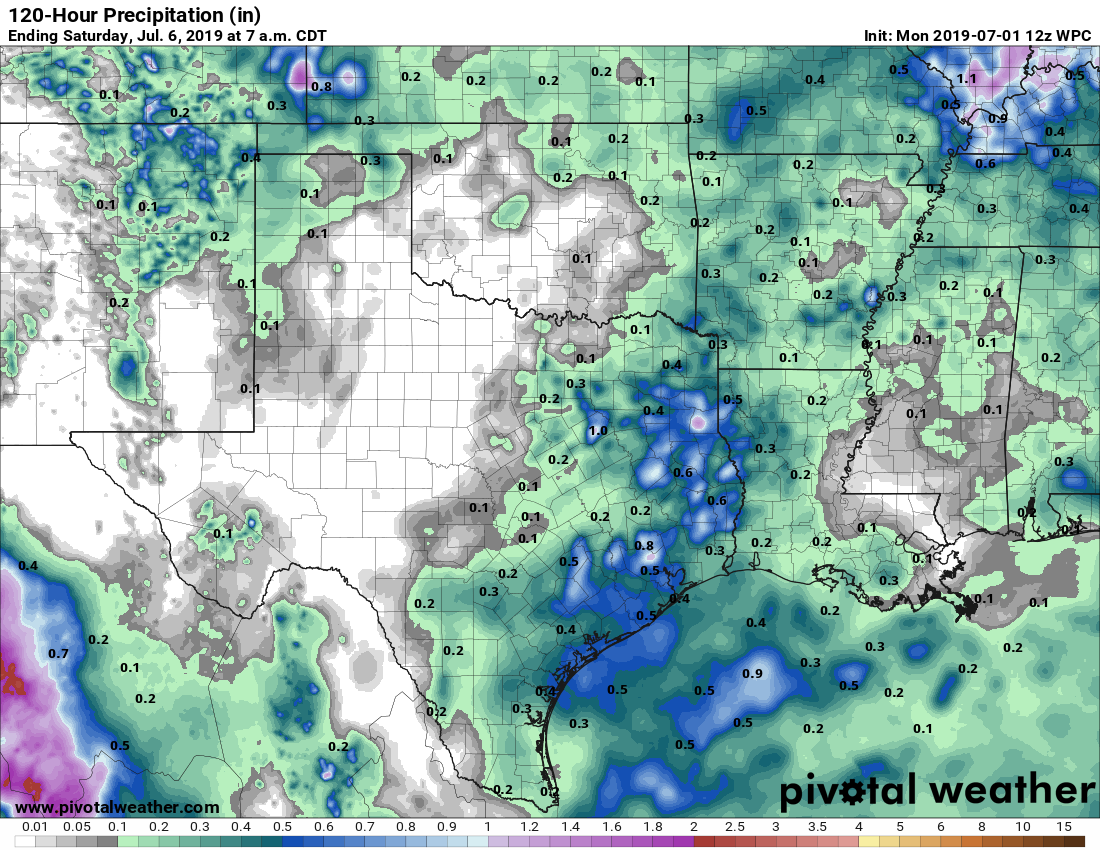
The region will fall under the influence of a more moist air mass from the Gulf of Mexico, and this will lead to increased rain chances for Tuesday, Tuesday night, and most of the day Wednesday. Right now there doesn’t appear to be too much to drive organization of these storms, and models indicate most of the area will see 0.25 to 1.0 inch of rain, with a few bullseyes of heavier rain where 1 to 3 inches may fall fairly quickly given the tropical nature of the moisture. These will be partly to mostly cloudy days, and the intermittent rain showers should limit highs to the upper 80s for most areas.

Houston to play rainfall roulette this weekend
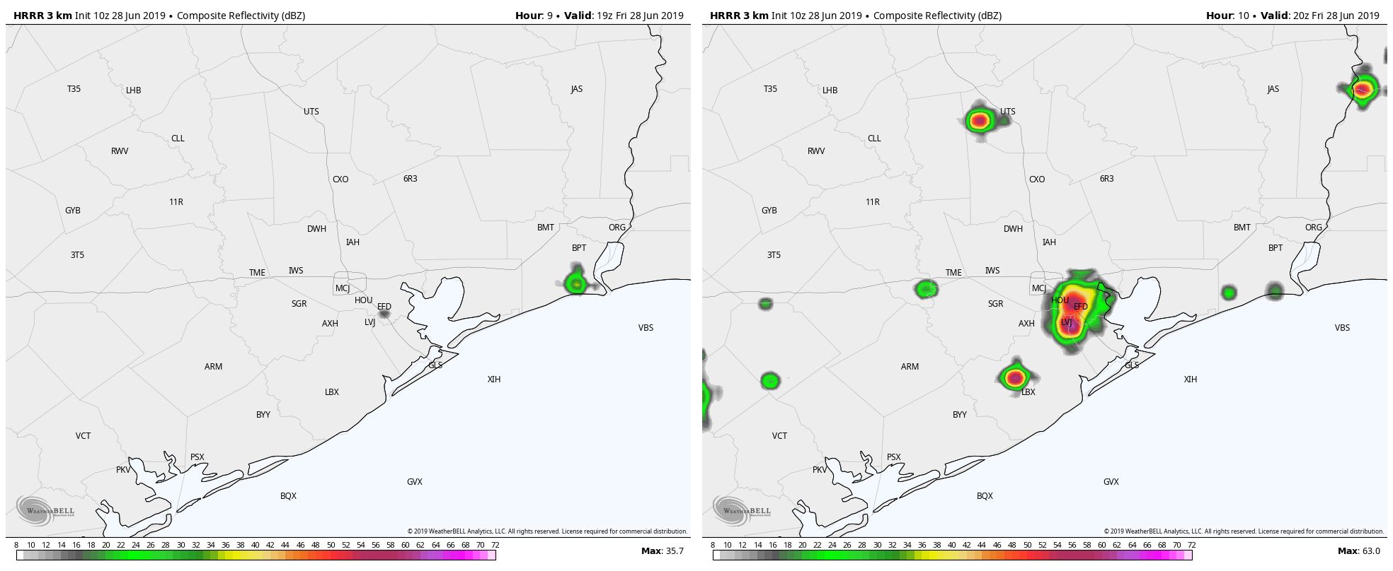
Well, so much for the high pressure that was supposed to tamp down on rain activity Thursday. Despite the influence of a ridge to the west of the region, some pretty strong showers still popped up over Houston, dropping as much as 1.5 inches near the Waller-Harris County line Thursday. I think we’ll be in for a similar pattern this weekend in which perhaps only 30 to 40 percent of the Houston area receives rainfall in any given day, but those areas that do see showers could experience some briefly heavy rainfall. Welcome to the game of rainfall roulette.
Friday
Mostly sunny skies this morning should allow temperatures to push up into the low- or even mid-90s by early this afternoon, and this will be warm enough to help generate some scattered showers and thunderstorms.
High resolution modeling suggests these storms will initiate around 2pm or 3pm and then wane by or before sunset with the loss of this daytime heating. Rainfall could be briefly heavy under some of these storms, potentially making something of a mess during the evening commute. However, we don’t have any flooding concerns beyond the usual mess on streets. Lows Friday night should fall into the mid-70s.
Weekend forecast looks decent, wetter early next week for Houston
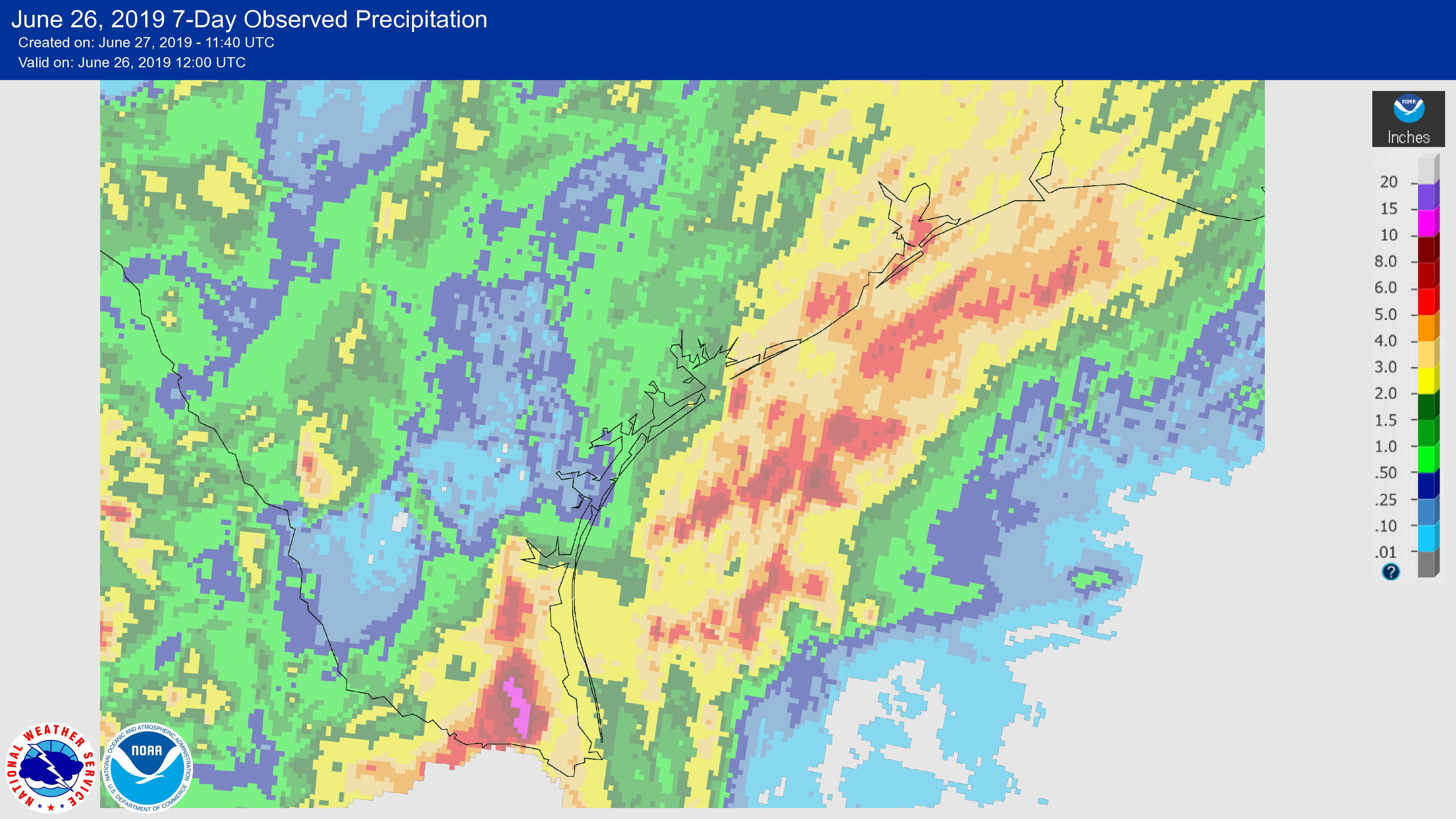
It has been a wet week for much of coastal Texas, with the combination of moist air moving inland, and the absence of high pressure to keep rainfall at bay. The Valley was hit especially hard, with areas near Harlingen and McAllen receiving in excess of 10 inches and experiencing some pretty significant flooding. Closer to home, parts of the coastal Houston region saw 3 to 5 inches of rainfall. We’ll now mostly dry out for a few days before the potential for some heavier rain returns early next week.
Thursday
Today should see the return of mostly sunny skies to Houston, although we can’t entirely rule out the possibility of a few isolated, pop-up storms. But for the most part, we’re just going to see a warm, June summer day with highs in the low 90s and moderate southerly winds. Overnight temperatures may lower into the mid-70s—if you’re lucky, and live far enough away from the coast.
Friday
This should be a similar day to Thursday, although we’ll probably see rain chances on the order of 10 to 20 percent, again in the form of some pop-up showers. Otherwise, expect mostly sunny skies with highs in the low- to mid-90s.