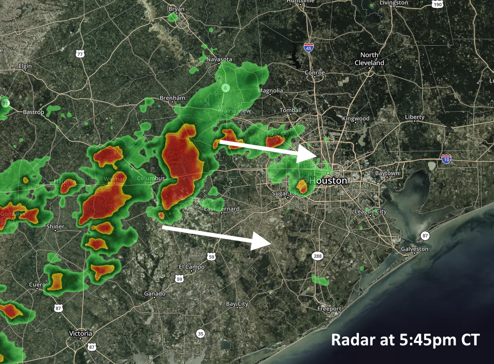
The National Weather Service has issued several watches and warnings for this afternoon and early evening as a fairly intense line of showers and thunderstorms is moving toward the Houston metro area from the west. These storms are capable of producing damaging wind gusts up to 60mph, and quarter-size hail.
Radar at 5:45pm CT Thursday. (kktv.com)
The severe weather has the potential to impact the entire metro area through around 8pm, but may linger across areas south of Interstate 10 until around midnight. The good news is they are moving rapidly from west to east, so individual storms should hopefully transition through the area quickly enough to avoid significant flooding problems.
Even so, it won’t be fun to be caught out in the storms, so please be weather-aware throughout this evening.
Good morning. We have a couple of more days with the potential for storms across Houston, but we’re not expecting anything like the widespread, long-duration showers and thunderstorms we experienced on Wednesday. This weekend still looks quite hot and sunny, especially Sunday.
Thursday
A line of storms has fired up early this morning, but it is weakening as it moves toward the Houston metro area. Unfortunately, however, these thunderstorms could bring another quick 0.5-1 inch of rain to hard hit parts of southern Fort Bend, Matagorda, and Wharton counties. After these morning showers, the region should see a break until later this afternoon or early evening. By this point another line of storms moving out of central Texas should approach the Houston area.
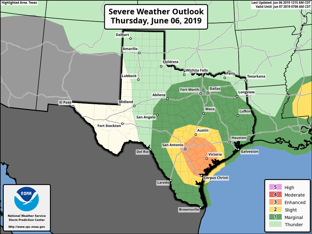
NOAA severe storm outlook for Thuesday.
These storms may (hopefully) weaken again as they approach Houston, and NOAA’s Storm Prediction Center has highlighted an area well to the southwest of Houston as seeing an “enhanced” chance of storms. Even so, in Houston we’ll need to be on the lookout for potentially severe thunderstorms late this afternoon and into the evening hours—right around the evening commute. The biggest threat will be damaging winds and possibly some hail. Since the storms will move through fairly quickly, we don’t anticipate any significant flooding, despite our sodden soils. Highs today will be in the low 90s.
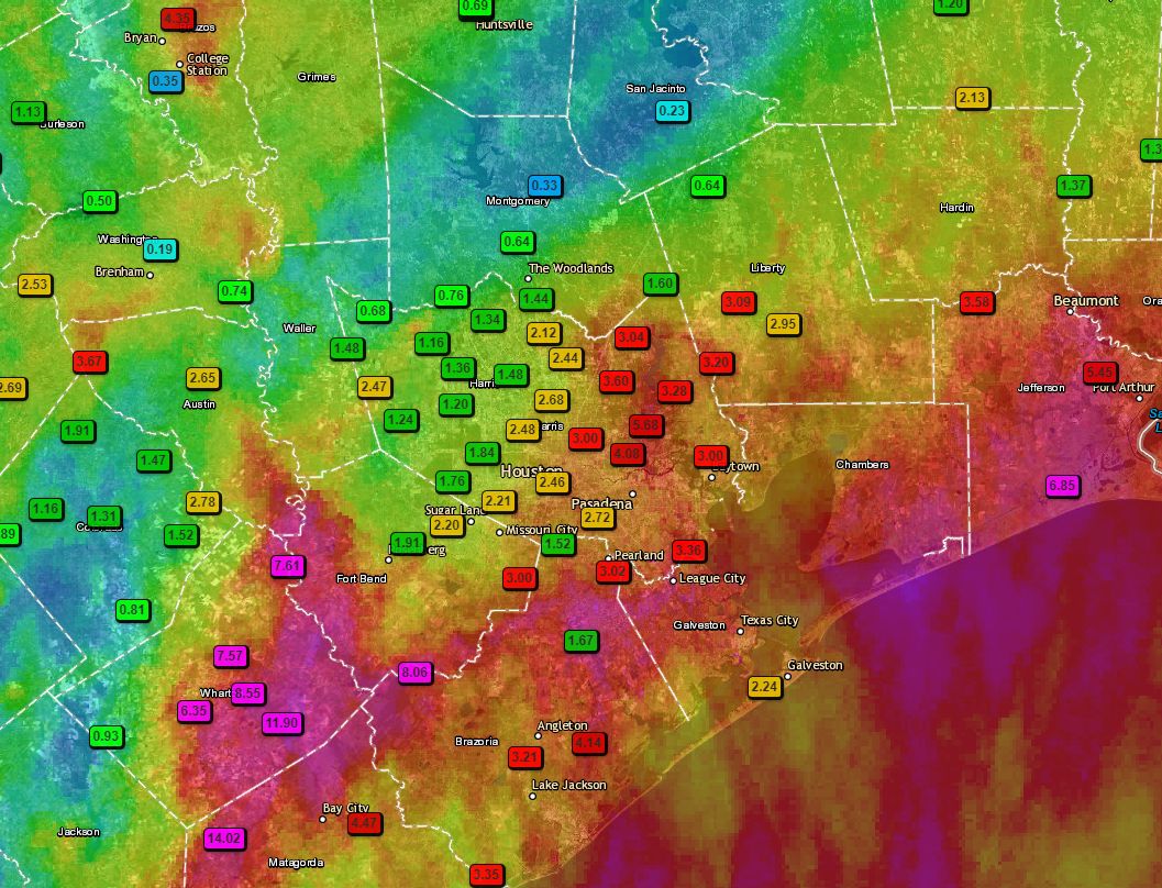
It’s been long day of storms for parts of the metro area—fortunately for Houston pretty much everything has now moved east toward Beaumont and Port Arthur, or (better) southeast into the Gulf of Mexico. Houston should (mostly) have a quiet night as storms fire to the east. Before getting to the forecast for the next few days, I wanted to share the following map of rainfall totals during the last 24 hours. It neatly illustrates the challenges of forecasting tropical precipitation along the upper Texas coast.
24-hour rainfall totals through 5pm CT Wednesday. (Texas Mesonet)
A few notes: We actually pinpointed the Matagorda region as a potential hotspot during the overnight hours, and they along with Wharton County certainly bore the brunt of heavy rainfall with 14+ inches in a few locations. An area near College Station also picked up 5 inches of rain, as did Port Arthur. Closer to Houston, the eastern half of Harris County got the worst of it on Wednesday. I would also like to point out that fewer than 100 miles separates Wharton, where a foot of rain fell, from Conroe, where one-third of an inch fell. Welcome to meteorology.
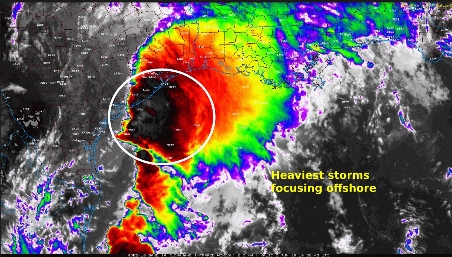
Over the last couple of hours, the radar has shown the heaviest rainfall congealing offshore, and this seems to be in response to falling pressures as the tropical disturbance moves north across the Gulf of Mexico. The net effect of this is that the offshore storms are robbing inland storms of moisture, and thus sapping their ability to produce really high rainfall rates like we saw earlier this morning near Wharton. This is good news for the rest of today, although we’re still going to see some scattered storms, and areas immediately along the coast, such as Galveston, may see intermittent heavy rainfall this afternoon.
Radar image at 11:30am CT shows offshore storms strengthening. (NOAA)
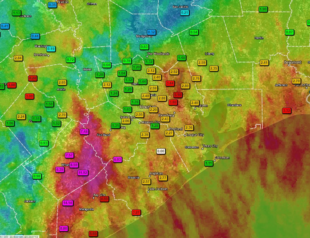
Most of the region has seen manageable rains today, and rainfall rates below 2 inches per hour. But we definitely saw the bullseyes we feared develop in Wharton, Fort Bend, and Matagorda counties this morning. One gauge north of Palacios recorded 14+ inches of rain, and a pretty large region saw 6+ inches since midnight. These totals are shown below.
24-hour rainfall totals for the Houston region. (Texas Mesonet)
The forecast for Wednesday evening through Friday remains tricky. Our best guess is that storms begin to redevelop onshore tonight, but the favored area is probably just east of Houston through the Beaumont area, and into southwestern Louisiana. In Houston, on Thursday, we will probably see less coverage than Wednesday—perhaps quite a bit less. We still have some concerns about later Thursday night and Friday, and we’ll address those in posts to come. My sense, however, is that the worst of this system, in terms of organized activity, is now slowly moving away from the metro area.