New Year’s Eve has dawned wet, gray, and cool but today’s weather should only improve from here as a modest cool front moves through and brings westerly winds to dry the region out. It appears as though we’ll see one more bout of rainfall during the mid-week period before a longer spell of drier weather settles over the region. Is anyone else tired of gray skies and on-again, off-again rain showers?
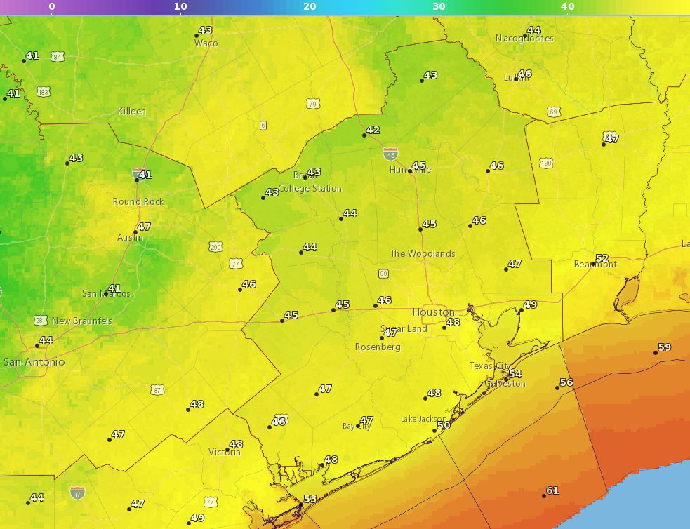
New Year’s Eve
Temperatures at midnight New Year’s Eve, as we ring in 2019. (National Weather Service)
Rain showers are ending from west to east, and should exit the area entirely by around 10am. We may see a few visits from the Sun later today, but skies will likely remain mostly cloudy this afternoon as temperatures rise into the low-60s. Fortunately, this front isn’t too strong, so we’re not going to see blustery conditions later today and tonight. In fact, as the sun sets this evening, winds should die down with it. Therefore, for festivities tonight, we can expect partly cloudy skies, temperatures near 50 degrees, and generally pleasant conditions. Please celebrate responsibly!
We took advantage of a slow Sunday morning to move Space City Weather to a new server, which should load even faster than before, and which should allow us to weather any traffic spikes during major storms. We were able to make this significant investment thanks to the generosity of our readers during last month’s fundraiser, as well as Reliant’s ongoing support. Please, if you notice any problems, use the feedback form to let us know. (More server specs in a minute).
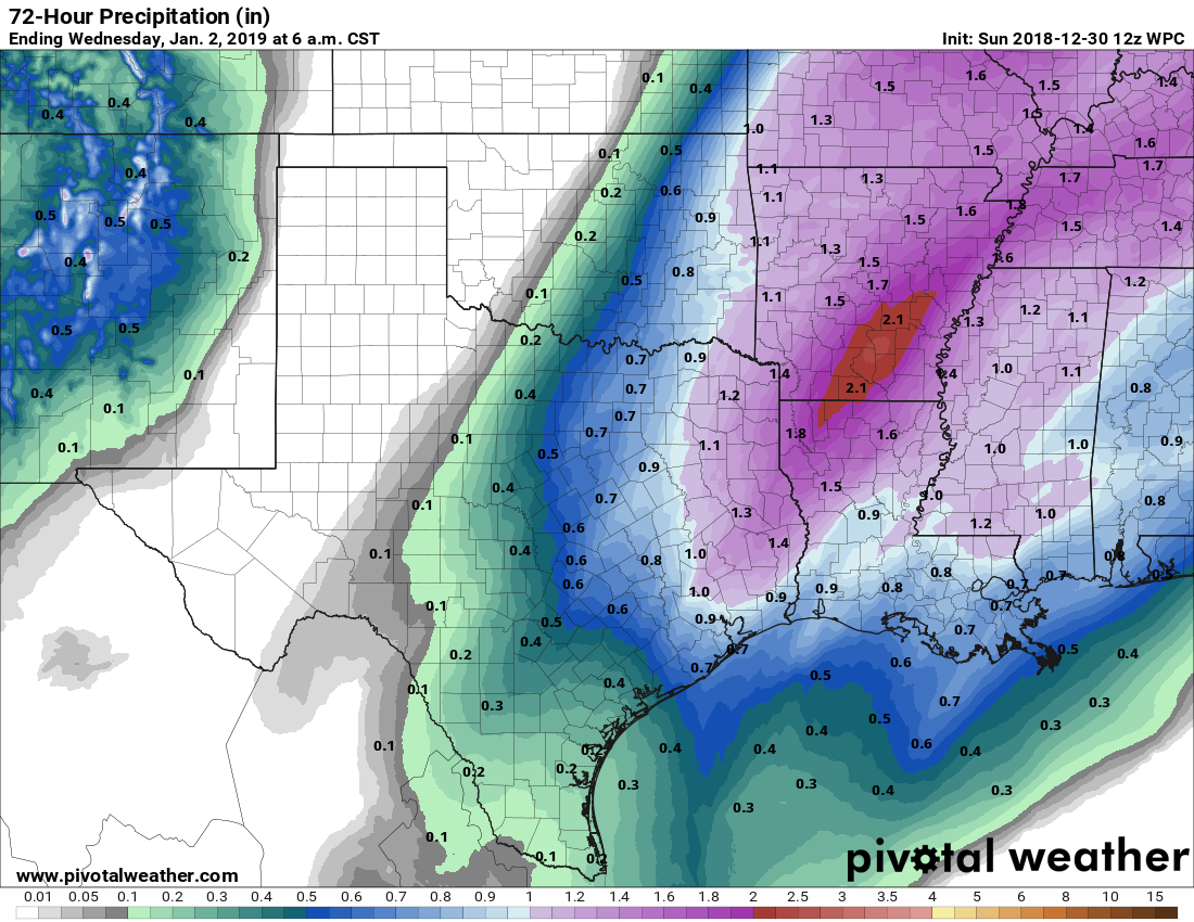
As for the New Year’s Eve forecast, it’s more or less on track. Above a small envelope of cool air at the surface, moisture from the Gulf of Mexico is streaming into the atmosphere above the upper Texas coast. The net effect of this is going to be on-again, off-again, light to moderate rainfall on Sunday, Sunday night, and Monday morning. Most of the region should see 1 inch or less of rain, so we don’t anticipate any problems.
NOAA rain accumulation forecast for now through New Year’s Day. (Pivotal Weather)
Fortunately, the rainfall should end by or before noon on New Year’s Eve, and we could see partly sunny skies with highs in the low 60s later in the day. As for the countdown to midnight, we expect partially clearing skies, with temperatures around 50 degrees and light winds. All in all, this is fairly good weather for New Year’s Eve festivities, so enjoy the celebrations.
As for our new server, we were fortunate to have Lee Hutchinson (a friend, and co-worker of mine at Ars Technica) do all of the back-end work for us. According to Lee, here are the details about our new server:
Space City Weather is now running on its own dedicated server, with no co-tenants and no sharing of anything. The box is a quad-core Intel Xeon E3-1230 with 16GB of RAM and dual 480GB SSDs in a RAID1 mirror, connected to the Internet via a dedicated 1Gbps uplink. We have plenty of room to grow and should be reasonably future-proof for at least the next several years.
Thanks again to all of our readers who supported us, and shared our site in 2018. We promise to deliver more of the same next year, with a site re-design and flood scale coming in the near future.
Good morning! The worst of Wednesday night’s and Thursday’s morning’s thunderstorms are now moving eastward, and the remainder of the storms should be off the coast by around 10 or 11am this morning. After several days of 70-degree weather, winter should now feel more like winter in the greater Houston area.
Thursday
Storms on Wednesday and Thursday brought a healthy amount of rain, with 1-3 inches generally, and a few reports of damaging winds. This morning, there are a few high-water sites on area roadways, but for the most part no major concerns. Temperatures have fallen into the mid-50s as the front moves through, and as rains end later this morning, we should see some clearing skies later this afternoon that will allow highs to get up to about 70 degrees. Lows tonight should drop down to about 50 degrees.
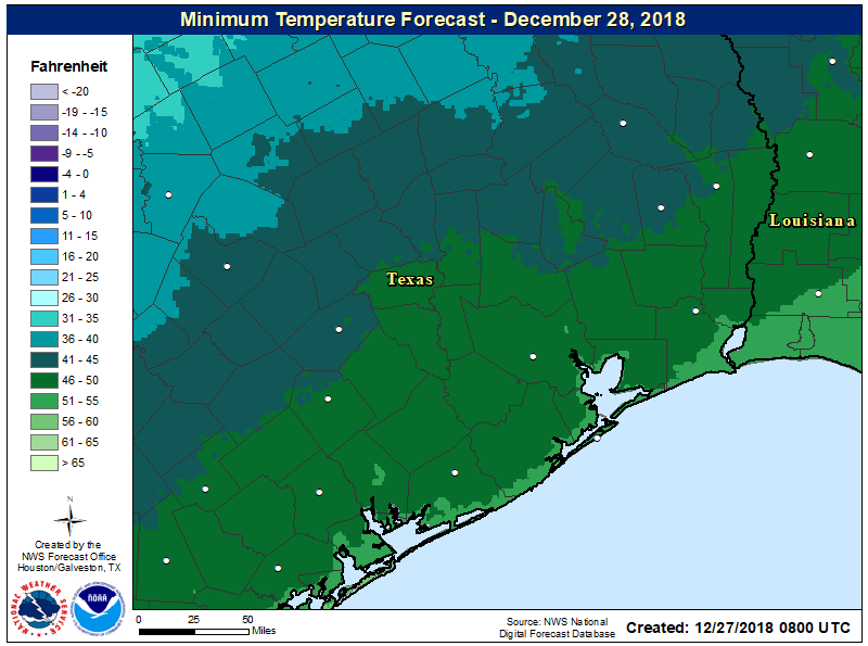
Friday morning forecast low temperatures. (NOAA)
Friday
This still looks to be the pick of the litter for this week, and perhaps next as well. Look for highs in the mid-60s, with mostly sunny skies, and light winds. This will probably be the last time we really see the Sun in 2018.
After rather sedate weather on Christmas Day, Houston will fall into a more dynamic weather pattern beginning later on Wednesday, with a front tonight and some potentially severe storms. No one wants a system like this, but at least it’s likely to strike during the overnight hours when most people are at home rather than out and about.
Wednesday
Temperatures are warm and muggy this morning, generally in the low 60s, which is more typical for highs this time of year rather than lows. Some showers and a few thunderstorms will be possible later this morning and this afternoon, but we’re not too concerned about accumulations (probably one-half inch or less for most areas). Highs today will probably top out at about 70 degrees under cloudy skies.
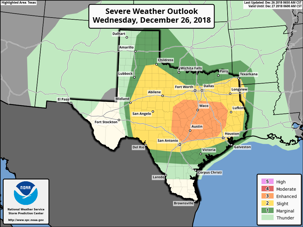
Severe weather outlook for Wednesday and Wednesday night. (NOAA)
After any daytime showers, we think there probably will be diminished rain chances this evening through at least about midnight. However, after that time a line of (likely) strong showers and thunderstorms will sweep from west to east, ahead of a cold front. It seems likely the line of storms will reach the College Station area between midnight and 3am, and push through the Houston area between 3am and 6am. The storms should be clearing the area by around sunrise or shortly thereafter. The primary threat is damaging winds, with a lesser threat of tornadoes (which should be short-lived).
In terms of rainfall, I don’t have a great amount of confidence in the forecast. A lot of models show a fairly progressive system, that should limit accumulations to 1-2 inches for most of the metro area. On the other hand, a few models are showing 2-4 inches, and several recent rain events have out-performed the model forecasts. My best guess is for 1-3 inches today and tonight, with higher isolated totals of 5 inches possible. The threat of heavier rain is generally to the north and west of metro Houston.