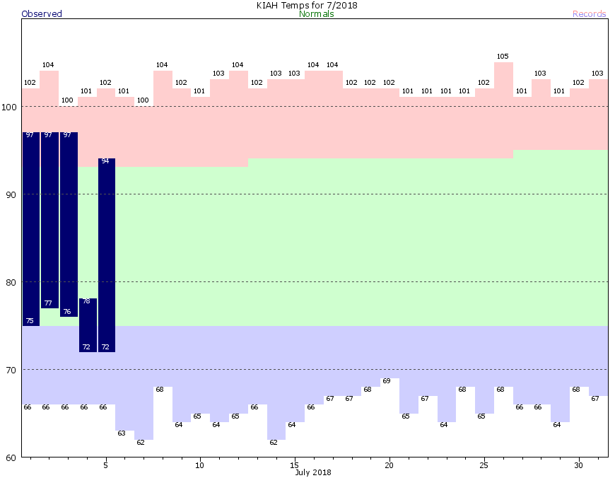
Spring arrives in Houston to stay—along with lots of showers

Houston had three consecutive days of 80-degree temperatures at the end of last week—the first time that has happened since mid-November. These warmer temperatures, generally in the upper 70s to 80 degrees are going to hang around this week, too. The other big story will be rainfall, with a couple of inches likely this week as moisture levels surge upward.

Monday

Today should be pretty nice, all things considered, and may be the best day of the week. We should see partly sunny skies, with only a slight chance of rain as high temperatures rise to about 80 degrees. The only concern is building southerly winds, which could make for a fairly gusty afternoon. These winds, and the moisture they bring, will be a harbinger for the rest of the week.

Tuesday and Wednesday

The primary dynamic beginning Tuesday will be increasing rain chances as a series of disturbances move into Texas from Mexico at the same time a slowly moving cold front moves toward the area and stalls. For now it appears the best rain chances will be north and northeast of Houston (certainly some flooding is possible for the areas facing 6 inches or more in the map below).

NOAA rainfall accumulation forecast for now through Sunday. (Pivotal Weather)

Rain chances appear to be highest from Tuesday night through Wednesday night, and I’d expect most of the Houston region to receive 1.5 to 2.5 inches, with higher amounts where heavy storms establish themselves. We’ll have to watch for the potential of street flooding. High temperatures will be in the upper 70s with warm nights.

See full post

And just like that, winter is pretty much over in Houston

The sunshine broke out on Wednesday afternoon, and this allowed Houston to record its first high temperature of 80 degrees for the year 2018. I joked on Twitter that this probably won’t be the last time it happens, but in reality I think Wednesday’s high was symbolic. We are in the midst of transitioning from winter to spring.

A lot of people have asked whether we are done with freezes. (My wife, a gardener, especially wants to know). We think so. Typically, the last freeze for central and southern parts of Houston (think Harris County and areas closer to the coast) occurs in mid-February, and for northern areas (think Montgomery, Waller, Liberty) it is late February or early March. This year it seems highly unlikely that the region will see a freeze for the next two weeks, which gets us to March. There are always outliers—for example, Hobby Airport recorded a freeze on April 13, 1940—but the odds at this point favor no more freezes for the winter of 2017-2018.

The 16-day GFS ensemble forecast shows low probabilities of overnight temperatures in the 40s, let alone the 30s, for the rest of February. (Weather Bell)

Now, onto the forecast.

Thursday

The dense fog is back for some areas, with an advisory in effect for the entire region until Noon Thursday. Please take a little extra time on roads this morning. After the fog breaks, we’ll be left with mostly cloudy skies, although I think we’ll have some more moments of sunshine this afternoon. The amount of sunshine will determine the high temperature, but I think its likely we’ll get back to 80 degrees today. Lows tonight will only fall into the mid-60s.

See full post

Why has Houston’s weather turned into Seattle?

Very warm, moist air in combination with a relatively colder air mass is a good recipe for fog, and that’s just what we’re going to have the next couple of days until a cool front moves through Friday. A dense fog advisory is in effect until 10am this morning, and even by then some areas may be slow to clear. Also, after the forecast, I discuss why our weather has been Seattle-like of late.

Wednesday

Temperatures are considerably warmer this morning, with overnight lows settling into the upper 50s and not falling any further. After the fog dissipates later this morning, or by noon, it will reveal—you guessed it—more cloudy skies above. Some light scattered showers will also be possible as high temperatures generally climb into the low 70s.

Expect a warm, gray day today. (Pivotal Weather)


Thursday

Expect another warm night, and this time low temperatures probably will only fall into the 60s. We’ll see more fog developing during the overnight hours, especially along the coast, where it probably will continue to play havoc with maritime activities. A chance of light rain will remain before noon, but I still have some hope that the region will see clearing skies later in the day. I’m hoping for some sunshine and highs in the mid-70s. Enjoy it, because this will probably be the only sunshine for awhile.

See full post

I’m hopeful Houston will have one partly sunny day this week

As brutal as it sounds, Houston may have just one partly sunny day during the next seven days—with the rest of our weather being mostly cloudy. But if that’s got you feeling blue (unlike the sky), just remember that for all of December, the city of Moscow saw only six minutes of sunshine. So as ever, it could be worse.

Tuesday

In a word, gloomy. The day will start chilly, in the low- to mid-40s for most of Houston. With widespread clouds holding on, we should see highs only in the mid-50s on Tuesday, and as moisture levels start to rise later today, we should also see some light to moderate rain showers—but accumulations shouldn’t be an issue. Low temperatures on Tuesday night will basically remain flat from the day’s highs, as warmer air moves into the region.

Wednesday

The warmer air will do its work and, despite mostly cloudy skies, we can expect high temperatures to climb into at least the low 70s on Wednesday.

High temperatures will rebound nicely across the region. (Pivotal Weather)

Some slight, scattered rain showers are possible, but by no means certain. Lows Wednesday night should only fall into the mid-60s. If you’re planning some kind of outdoor activity for Valentine’s evening, I think the weather should mostly cooperate.

See full post