After a pretty nice weekend—Sunday morning’s showers aside—our weather will turn warmer and more humid this week before a strong front arrives before next weekend. We’re not looking at anything too extreme, but we can definitely anticipate some showers and thunderstorms on Thursday and Friday.
Monday
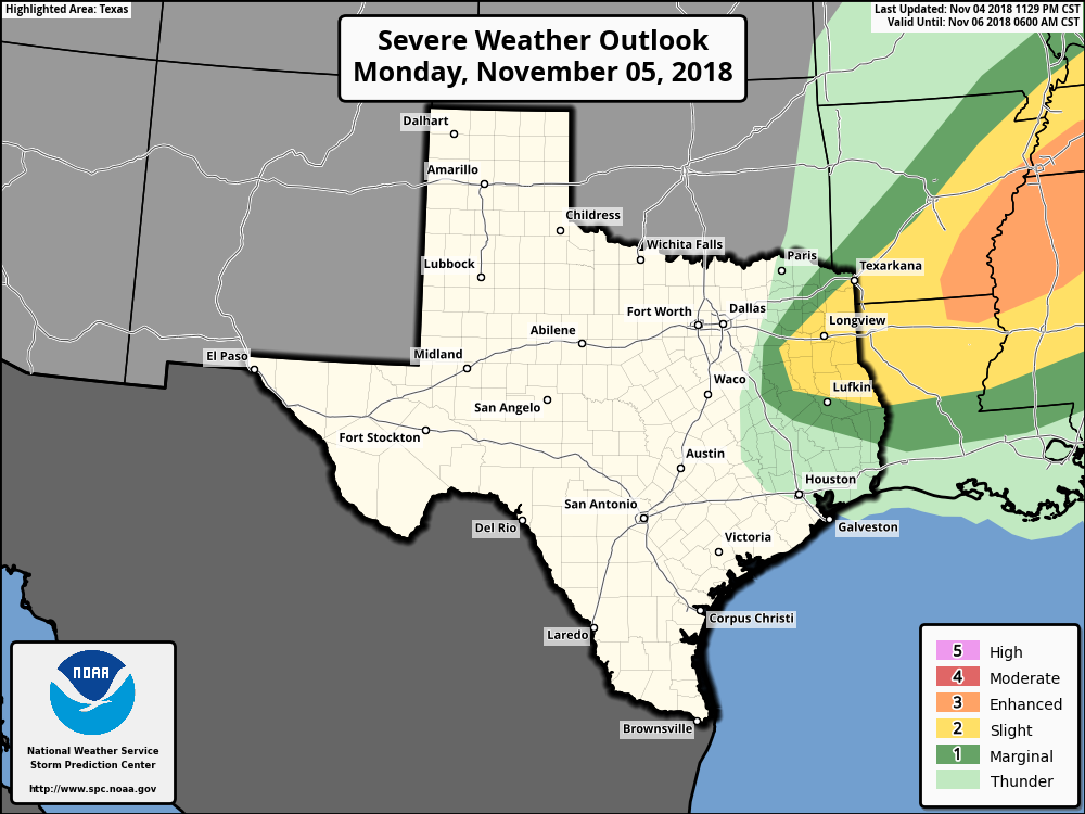
The weak cold front that pushed into the offshore waters on Sunday is moving back onshore today, and we’ll feel that later this afternoon in the form of stronger southerly winds and rising humidity. Expect highs in the low 80s, with mostly cloudy skies. A word of warning if you’re traveling up into east Texas or Arkansas today, as that area faces the potential for some severe weather due to a separate frontal system. Rain chances should be near zero in the Houston metro area itself.
Severe storm outlook for Monday and Monday night. (NOAA)
Tuesday
Another warm day, with high temperatures in the low to mid-80s, depending upon the extent of afternoon sunshine in your area. Highs will probably be 8 to 10 degrees warmer than normal for this time of year, but the heat won’t last too long. Rain chances will be in the 10 to 20 percent range.
Well, that’s all over. We survived Wednesday afternoon’s storms, the rains ended long enough for most people to do some trick-or-treating, and then a strong front blew through Wednesday night. The squall line of storms produced wind gusts of up to 50mph along the coast. Rain totals over the last 24 hours were impressive, too, ranging from about 1.5 to 4.5 inches, enough to cause some street flooding, but those concerns are ending now with drier air moving into the area, behind the front. Some splendid weather lies ahead.
Thursday
It’s chilly outside this morning, so don’t forget to bring a light jacket. Temperatures are generally hovering around 60 degrees in the city, with a brisk northerly wind at around 15 mph. Highs won’t rise too much, probably into the upper 60s, even as skies clear later today. All of this colder, drier air moving into the region should bring Houston its coldest night of the season on Thursday night, with inland areas likely seeing low temperatures in the 40s.
Houston should see its coldest temperatures of the season on Friday morning. (Weather Bell)
Friday
This should be an amazing day, with a cool start, sunny skies, and high temperatures of around 70 degrees for the most part. We’ll see another chilly night on Friday into Saturday morning, but overnight temperatures will be a few degrees warmer across the area.
Just a short update on the forecast for Halloween, which remains more or less on track. As of 4pm CT we’re in the midst of daytime-heating driven thunderstorms firing up along a boundary running through the Houston area. We’re hoping to see some of this activity die down between 5pm and 7pm, as the sun goes down, but we can’t guarantee it won’t rain in your area.
If you’re trick-or-treating, the best advice is to seize the moment when it’s not raining around sunset; but remain relatively close to your home or vehicle. While there should be fewer storms across the area around sunset, we’re still concerned about the potential for strong thunderstorms and other threats popping up quickly. If you hear thunder, please take shelter.
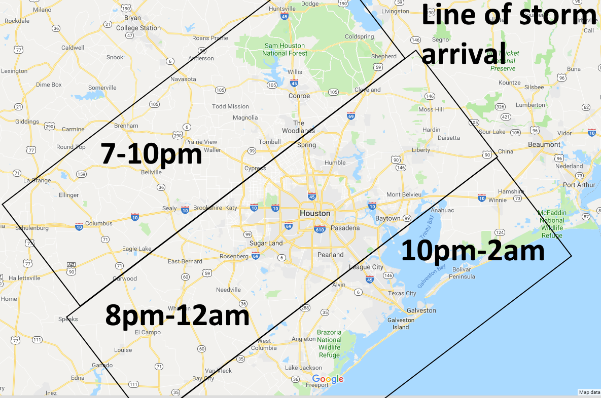
The main event will come a little later this evening, with the arrival of a cold front and a line of severe thunderstorms moving from northwest to southeast.
Estimate of arrival time for cold front and associated line of strong storms. (Space City Weather)
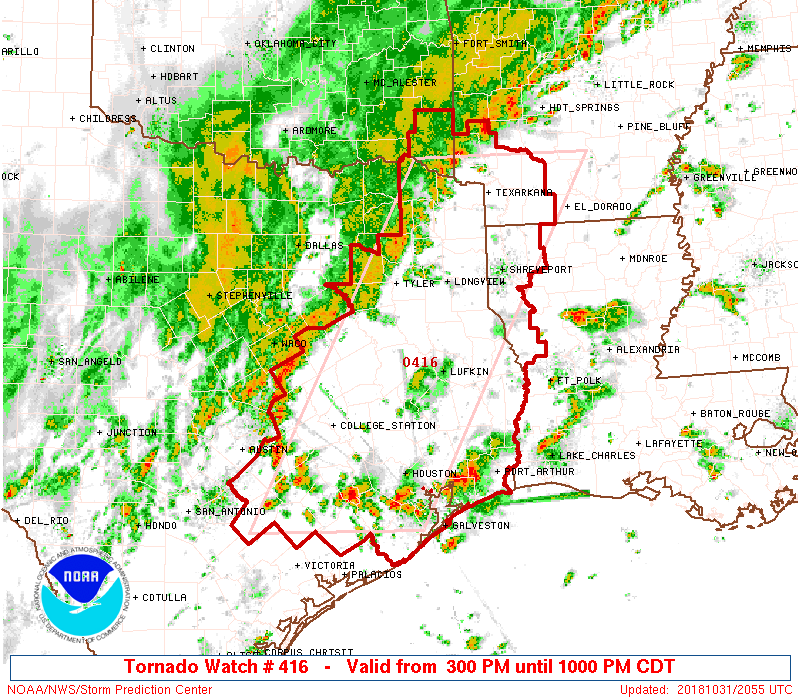
The timings we shared this morning remain pretty much accurate. Along with the warning messages about the potential for some heavy downpours, high winds, and other severe weather, the National Weather Service went ahead and pulled the trigger on a tornado watch for much of East Texas. It expires at 10pm, but once the front passes through your location, and the rains stop, you can consider the need for the watch ended.
Area of tornado watch for Wednesday. (NOAA)
Please remember that a tornado watch simply means that conditions exist for the possible formation of tornadoes, not that one has been spotted. And while it is certainly possible for tornadoes to form this evening, we don’t envision a huge threat.
All the same, it’s going to get briefly nasty out there as this cold front blows through Houston tonight. Please have plans to be somewhere safe during the passage.
Unfortunately, we don’t have a whole lot of good news about the forecast for Halloween, although we’re not ready to declare trick-or-treating a bust. For pretty much everyone, we expect trick-or-treating this evening to be a “game time decision,” and parents will have to be attentive to thunder, because scattered showers and thunderstorms will be possible during the evening hours. Later, for Halloween parties, we have concerns about the roads late tonight as storms associated with a cold front move through. By the way, if you’re so inclined, we’re now posting to Instagram if you want to follow us there for updates.
Wednesday
Our forecast for Halloween remains more or less the same, with two main threats for the Houston area. There are thunderstorms this afternoon ahead of the cold front, and then later this evening the cold front and almost certain storms accompanying it.
This morning, we’ll see scattered light to moderate rain showers, but our concerns really won’t kick in until this afternoon. By this time an unstable air mass, temperatures in the mid- to upper-80s, and ample moisture will create an environment that is favorable for thunderstorms. Short-range forecast models show at least scattered thunderstorms firing up across much of the area between 1 and 5pm. Some of these storms could produce locally heavy rainfall.
The real question is when these storms wane—it seems possible, and perhaps even likely that they will begin to die down toward sunset and the loss of daytime heating. This may create a window early this evening in the range of 6 to 8pm for kids to get out, about, and grab some candy. We’re hopeful, but far from certain.
Estimate of arrival time for cold front and associated line of strong storms. (Space City Weather)
However, this window may shut quickly, especially for northern and western areas, such as Sealy, Tomball, Cypress and The Woodlands as a cold front sweeps down toward the area. Models generally agree that a line of strong and potentially severe thunderstorms will develop along the front as it moves from northwest to southeast across the area. We have concerns about abundant lightning, heavy rainfall, damaging winds, and potentially hail.
As far as timing, our best guess is that these storms roll into northwestern areas of Houston between 7 and 10pm, central parts of the city from 8 to midnight, and coastal areas from 10pm to 2am.
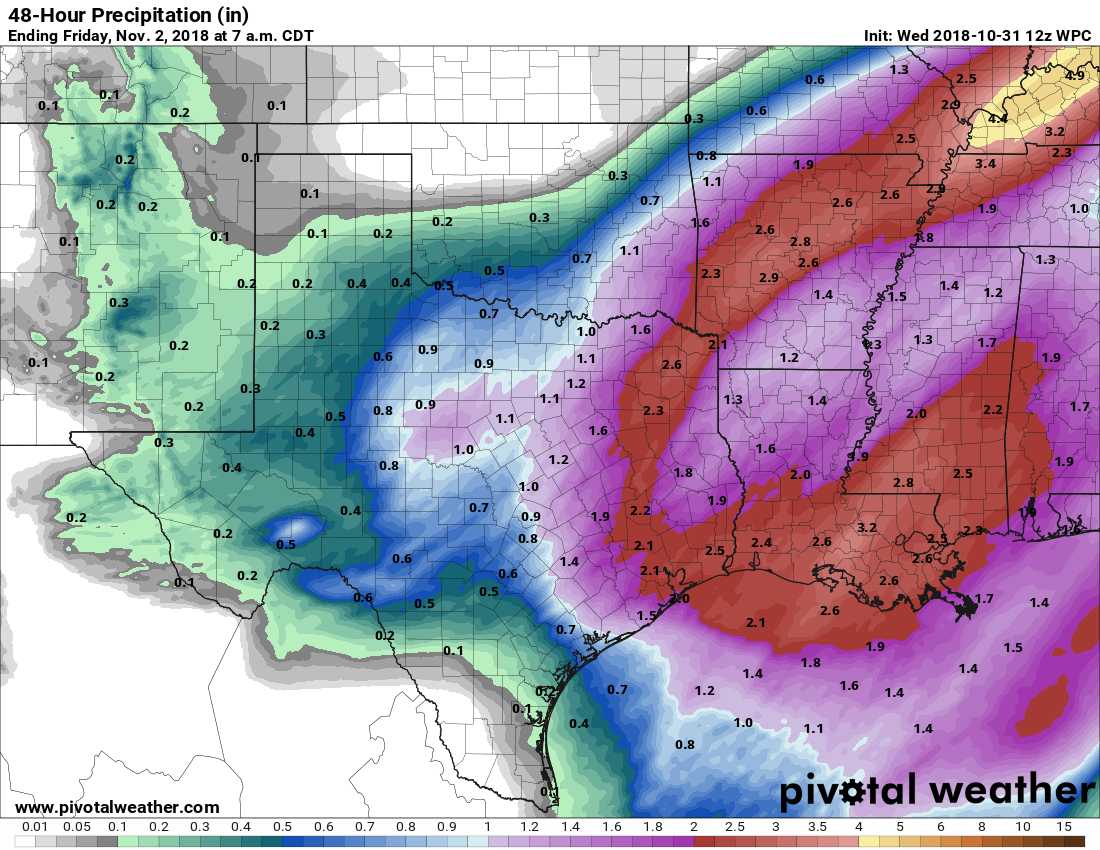
NOAA rain accumulation forecast for now through Thursday. (Pivotal Weather)
Between this afternoon’s thunderstorms, and the certain overnight rainfall, we expect to see some healthy precipitation totals for most of the area. We now expect most of the Houston region to see about 2 inches of rain, give or take. However, we probably will see some isolated totals in the 4-inch or greater range for hardest hit areas. This will probably cause some temporary street flooding tonight, so again if you’re planning to be out in roughly the midnight time frame tonight, please take extra care.