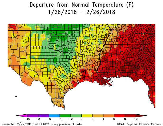
Expect more showers Friday and Saturday before Houston clears next week

Let’s face it, Tuesday’s cool front hasn’t done a whole lot of cooling. While some parts of Houston have fallen into the upper 50s, most of the central and southern part of the region have only fallen into the low 60s. We’ll have to wait until this weekend for a somewhat stronger front.

Today

Mostly cloudy skies and an easterly wind should hold temperatures today down to about 70 degrees, but there should be no rain. Clouds and winds shifting to the southeast tonight will preclude overnight lows from falling further than into the mid-60s for all but far inland areas.

Thursday

While we can’t rule out the possibility of some scattered showers on Thursday, as moisture levels rise, it looks like most of the area will remain dry. Skies will again be mostly cloudy, with temperatures rising into the mid- to upper-70s.

Friday and Saturday

A combination of increased moisture levels, and lower pressure systems moving in from the west will lead to the likelihood of rain showers and potentially some thunderstorms on both Friday and Saturday. In terms of accumulations I don’t think the area will be looking at more than 1 to 2 inches of rain—with isolated totals a bit higher than that—during the end of the week.

NOAA rain accumulation forecast for now through Sunday morning. (Weather Bell)

See full post

Storms possible today, and rain returns later this week to Houston

It’s another warm morning across Houston, with temperatures generally having fallen only to about 70 degrees. The main concern today will be the possibility of some storms and heavy rain along with the passage of a cold front.

Today

A cold front now in north Texas will move down toward the Houston area, likely pushing through the city during the mid-afternoon hours, and the off the coast by late afternoon. Due to decent moisture levels and and lift associated with the front, much of the area is likely to see some moderate to briefly heavy rain with the front’s passage. I’m expecting on the order of 0.5 inch to 1.0 inch or so, late this morning and during the afternoon hours. The storms may slow, or even stall along the cost, producing more rain there. Along with the front there will likely be some embedded thunderstorms, and a slight chance of some hail. After the front passes tonight look for temperatures to fall into the mid- to upper-50s.

(National Weather Service)

Wednesday

With northerly winds and partly cloudy skies the day will be moderately cooler, with highs in the low 70s. A very slight chance of rain returns during the late afternoon and evening hours. Most of the cooler air is gone by Wednesday night, allowing low temperatures to fall only into the 60s.

(Space City Weather is sponsored this month by an anonymous donor.)

See full post

After Sunday’s heavy rains, more storms possible Tuesday in Houston

Obviously, the big story this weekend was heavier than anticipated rainfall on Sunday. Our Friday forecast for the weekend was not particularly good. We missed on the potential for heavy rainfall and storms on Sunday, when some areas of southern Harris County recorded as much as 6 inches of rain. While there were no major flooding events as a result of the rain, and most of the region received 1.5 inches of rain or less, it is nonetheless regretful. It also serves as a reminder of the challenges of predicting heavy rainfall along the Gulf of Mexico.

Rain accumulation from early Sunday through early Monday. (NOAA)

Monday

It’s another very warm morning for early spring, with low temperatures only falling to around 70 degrees for most of the Houston area. After Sunday’s widespread showers, moisture levels remain fairly high over the region, but there’s not the same forcing to really drive the development of rain. As a result I think we’ll see some scattered rain showers later this morning and afternoon, but nothing too widespread. Highs will be around 80.

(Space City Weather is sponsored this month by an anonymous donor)

See full post

After two splendid days, rain returns to Houston this weekend

A sense of normalcy has returned to Houston this morning, as temperatures have fallen into the upper 40s across most of the region. This will be but a fairly brief respite, however, from the warmer weather of late. Also, we’ll probably see rain this weekend.

Today and Friday

In the wake of Wednesday’s cold front, pleasant weather will predominate for Houston, with highs in the upper 60s to 70 degrees, and cooler nights. How cool? Temperatures tonight could fall into the low- to mid-40s for many inland areas, and this will bring a real chill into the air. Friday night will be warmer, with the onshore flow starting to resume, but I still expect lows to fall to around 50 degrees for most areas. Skies will be partly to mostly sunny, with winds around 10 to 15 mph.

Saturday and Sunday

As the onshore flow resumes, rain chances will return to the metro area this weekend. The temperature forecast, at least, seems fairly clear. Both days will see highs from the upper 60s to low 70s, dependent somewhat on cloud cover, and lows probably down to around 60 degrees. The difficult part of the forecast comes in determining rainfall, which will depend upon the evolution of a low pressure system moving up into the region from south Texas on Saturday. The forecast models just don’t have a good handle on this yet.

Estimated rainfall totals for Houston for this coming weekend. (Weather Bell)

See full post