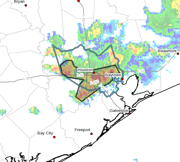
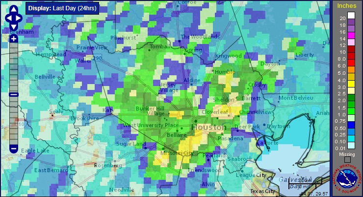
Houston’s wet, cool August continues—and Labor Day weekend looks nice

Most of Houston saw cloudy skies, but not too much rain this weekend. But the same cannot be said for some coastal areas, particularly in Matagorda and Brazoria counties. As much as 10 inches fell in the Freeport area, and coastal regions in Matagorda, Brazoria, Galveston and Chambers counties remain under a flash flood watch through at least noon today.

Very heavy rains fell south of Houston, on the coast, on Sunday. (NOAA)


Monday

These coastal areas could pick up another couple of inches today as a slow-moving area of low pressure drifts slowly down the Texas coast. While it is not particularly a threat to develop into a tropical system it will remain a rainmaker all the same.

Truth be told, heavy rain is possible for most of the Houston metro area today, as daytime temperatures warm up. Some parts of town could pick up 1-3 inches whereas other areas see threatening skies, but little to no rain. Highs should remain in the upper 80s.

Tuesday

Conditions should dry out some on Tuesday, with less heavy rain, but we’re still likely to see partly cloudy skies, intermittent rain and highs only of about 90 degrees. Don’t look now, but it’s almost the end of August, and fall isn’t too far around the corner.

See full post

The Atlantic tropics are sizzling with a hurricane and two depressions

As one might expect at the end of August, the tropics are very active today. Here’s a Sunday roundup of everything that’s going on, with an emphasis on what might affect the Gulf of Mexico.

GOES-East image as of 2:47pm CT Sunday. (NOAA)

Hurricane Gaston

Gaston may be a beast, but we can only admire his eye and 105-mph sustained winds beauty from afar. A quick summary:

No one stays away from land like Gaston!

No storm is worth ignoring like Gaston!

Tropical Depression 8

This storm developed quickly on Saturday night and Sunday morning, and may become Tropical Storm Hermine during the next day or so. This system is going to move toward the North Carolina coast by Tuesday or so, but shouldn’t strengthen much further due to increasing amounts of wind shear. Should still be a rainmaker for the Carolinas and possibly Virginia this week before it moves back out to sea.

Invest 99L-Now Tropical Depression #9

Ahh, our old friend Invest 99L. It seems like we’ve been tracking this undeveloped tropical wave since about 2013. Matt joked that it might be the first Invest to ever get “retired” by the National Hurricane Center. With that said the system does look a little bit better on satellite today, and the hurricane center just upgraded it to a tropical depression. Here’s a look at the track models:

12z track models for Invest 99L. (NCAR)

See full post

After a couple of hot days, summer lite returns to Houston

After two drier, warmer days in the mid-90s—typical weather for August—Houston will slip back into a mild, wetter pattern.

Today

As high pressure has retreated some, and moisture levels are fairly high, I’m expecting some fairly decent shower and thunderstorm coverage today, especially across southern parts of the metro area where precipitable water levels should be highest. Expect highs around 90 degrees, perhaps a bit higher to the northwest of Houston where rain chances should be lower. Showers may linger well into the evening and overnight hours.

Friday through Sunday—Mild temperatures

A series of disturbances seem likely to approach the region this weekend, beginning on Friday, and with a tropical airmass in place we can expect to see a fair amount of rain coverage. These three days should see partly to mostly cloudy skies, and on-and-off rain showers. I’m not expecting anything too extreme, and most of the Houston area will likely see 2-3 inches of rain or less. However we can’t rule out some locally heavy rainfall, and brief street flooding, where the strongest storms develop.

Highs will be blessedly cool for late August—likely only in the upper 80s each of the three days.

Temperatures on Friday could be a solid 8 to 10 degrees cooler than normal for August. (Weather Bell)

See full post

A comprehensive update on the potential Gulf hurricane

By now most readers have heard about the tropical low pressure system in the Caribbean Sea, which is approaching Puerto Rico. It is not a tropical storm yet, as a reconnaissance aircraft on Wednesday failed to find a well-defined circulation. It nonetheless appears to be developing stronger thunderstorms, and is producing tropical storm-force winds. It likely will become a depression and then a storm later this week as it passes near the Bahamas and then tracks toward Florida.

The purpose of this post is to discuss what may happen after that, but before doing so, I want to discuss the fallibility of forecast models at this time, and why we don’t have that much confidence in where the system, Invest 99L for now, will go in five to seven days, if it does head toward the Gulf of Mexico.

Model inaccuracy—it’s considerable

Let’s focus on track models. They tell us where a storm will go. Although models can do a fairly good job simulating the large scale steering currents that guide storm motion, such as upper-level pressure systems, these forecasts remain sketchy when a tropical system is poorly defined. And as I noted earlier, Invest 99L has yet to develop a center of circulation.

With that said let’s look at track errors for National Hurricane Center forecasts for three classes of storms: hurricanes (which have well defined circulations), strong tropical storms (likewise) and depressions and weak tropical storms (not so much). Actually, the category we’re interested in isn’t even on this chart—”stuff that ain’t formed yet.” Thus at five days we can expect the track error to be at a very minimum of 350 nautical miles for undeveloped tropical systems, and likely much, much more.

(National Hurricane Center)

See full post