A mostly quiet mid-August week ahead

Good Monday morning! Matt here this morning, covering for Eric. Thanks again to Eric for covering me in my opening days of fatherhood. Thanks to all for the comments and well wishes over the last couple weeks. I apologize for any typos, though I’ll blame it on the lack of sleep.

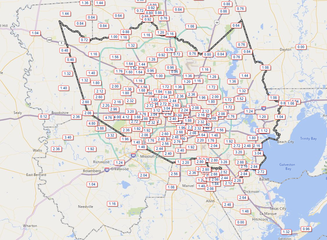
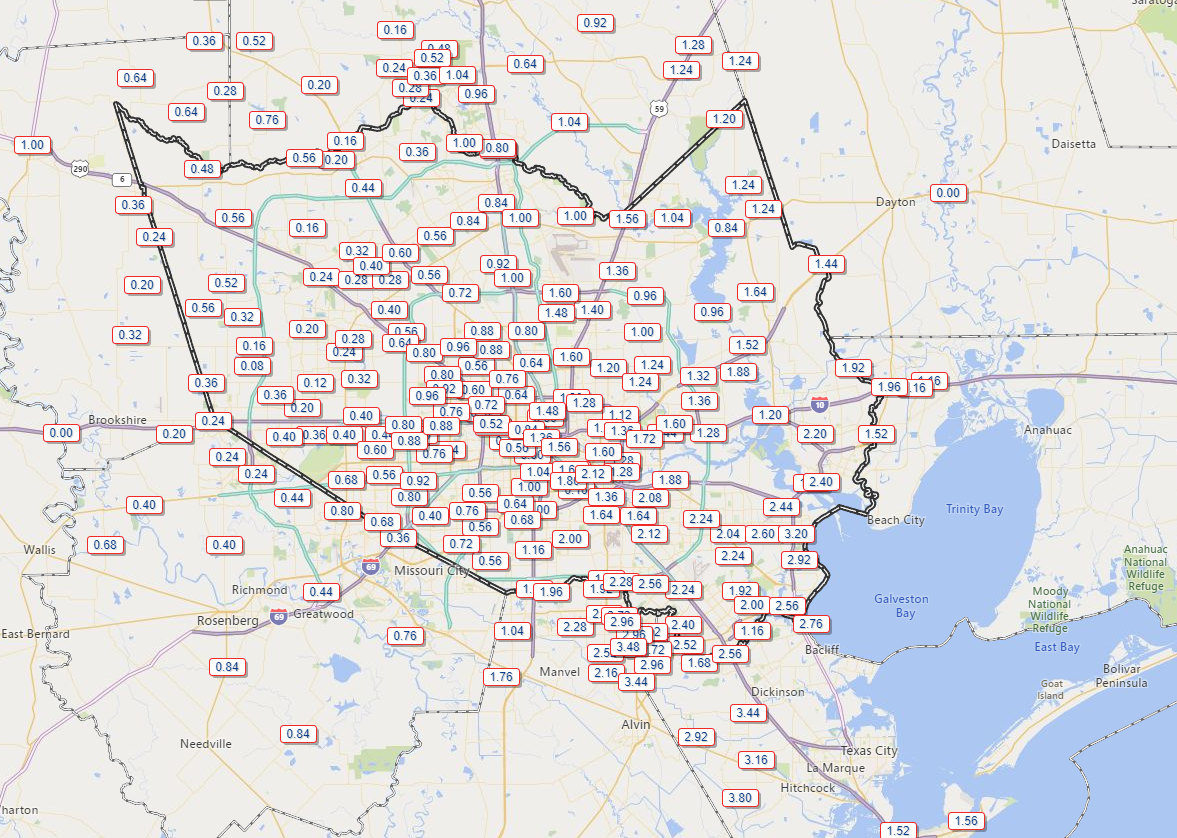
The Houston area has seen repetitive rounds of thunderstorms over the last week and change, but as someone who has been shut out most of the time, I’ve taken notice that the total rainfall distribution has been somewhat erratic.

Rain totals this month have been somewhat erratic around the region. (Harris County Flood Control)

Some areas have seen as much as three to five inches of rain this August, while others have seen a tenth of an inch or less. The winners appear to be in eastern Harris County and also up toward The Woodlands southwest toward Cypress. Waller County has done well also. So it’s been feast or famine for much of the region in August. Looking ahead to this week, the faucet will slow to a trickle for a couple days, and mostly typical August weather sets in.

Today & Tuesday

Our weather pattern has begun to change a bit, as high pressure and dry air begin to flex overhead. This should significantly limit storms in our area this afternoon. Expect high temps in the mid-90s. On Tuesday, we’ll see more of the same, though the rain chances may not be quite as limited. So, we’ll call it just a slight chance of showers. More mid-90s are expected.

There was a good bit of Saharan dust in the skies yesterday. Expect more of that today. Dust will slowly thin out on Tuesday and Wednesday. Air quality will be poor. This sort of thing will be worst for those with respiratory ailments. It’s also not optimal for those of us with regular seasonal allergies. The good news is that Saharan dust outbreaks tend to have peaked by now. So these events should become a little less frequent and intense as we move forward.

Wednesday through Friday

Typical August weather in Houston can be expected to round out the week. Temperatures will probably be one or two degrees cooler than usual, but that will hardly be noticeable to most of us. We’ll peak with highs in the mid-90s and lows in the upper-70s.

See full post

Hottest yet to come for Houston, as Texas roasts

Thursday was the hottest day yet in this heat wave that is scorching much of Texas. It was also Houston’s hottest day since June 5th. We hit 98° officially at Bush Airport (96° at Hobby).

Across Texas, it was quite a day. Here’s a rundown of the noteworthy temperatures and records set:

  • Energy demand across Texas was the strongest it has ever been, with the Electric Reliability Council of Texas, or ERCOT establishing another record, breaking the previous one just set on Wednesday.
  • Houston‘s low of 80° tied a record warm minimum temperature for July 19th.
  • College Station hit 100° yesterday for the first time in 2018.
  • Dallas, Waco, and San Angelo set record high temperatures for July 19th of 108° on Thursday, breaking records from 1925, 1951, and 2011 respectively.
  • Incredibly, Lubbock, TX didn’t drop below 81° yesterday for the first time on record, their warmest low temperature for any date by two degrees. Records in Lubbock date to 1911.
  • Midland, El Paso, and Amarillo each hit 105° for a high yesterday, tying records for Midland and El Paso for the date and setting a new record for Amarillo, which had been 102° last set in 1936.
  • Austin hit 104° and San Antonio hit 99°, neither of which were records.
  • Across the border, Shreveport, LA hit 104° yesterday, tying a record for Thursday last set way back in 1875.

The heat hasn’t even peaked yet, certainly not for Houston, so expect more impressive numbers and records to come. Let’s run through the forecast.

Friday & weekend

All three days look similar from a pure weather standpoint: It will be sunny and hot into Sunday. Please use caution if outdoors. Yes, we’re used to hot weather, but what’s coming this weekend is the next level of heat for our area that we see maybe once or twice per summer.

Some heat safety tips. Limit your time outdoors, don’t forget to check the backseat of your car, and please don’t forget about pets. (NWS)

It cannot be emphasized enough, especially after news of yesterday’s tragic death of a 3-year old left in a day care bus in northwest Houston, but always double check your vehicle before locking it and walking away.

In terms of just how hot, I would say we hit 98-100° officially today, followed by about 99-101° Saturday, and 101-103° Sunday. While Houston has been on the periphery of the strong upper level ridge of high pressure that has caused this heat, it will advance toward us in a big way this weekend, giving us a taste of what North Texas has been experiencing. How generous.

Official NWS forecast high temperatures over the next few days have lots of 100s showing up. (NWS)

We get very little relief at night during this kind of heat, so expect low temperatures to get just below 80° in most places and not much better than that.

See full post

SAL to visit Houston again this weekend

Our old friend SAL, the Saharan Air Layer (dust from the Sahara Desert in Africa) will be making a return visit to Texas this weekend, at least in higher quantities than we’ve seen this week. It will bring some grimy air quality by Sunday, as well as some potentially interesting sunrises and sunsets.

Model data from NASA shows thicker Saharan dust arriving in Houston on Sunday and Monday. (NASA)

You can see from the animation we’ve put together with NASA data that the brightest colors, or thickest dust arrives on Sunday afternoon, and it should be with us through about Tuesday. Dust has been with us to some extent much of this week, but it will be much more noticeable by later Sunday. So if you are an allergy sufferer (raises hand) or have respiratory ailments, worsening air quality on Sunday and Monday may cause you some discomfort. Air quality should improve after Tuesday. If interested, you can check the Texas air quality outlook here.

Today through Sunday

We’ve had a bit of a late start to thunderstorm activity over Houston the last two days, waiting until 3 PM or later in most cases. Yesterday’s storms were particularly frisky, with parts of Houston’s Inner Loop and West Houston seeing 1-2″ of rain. The Woodlands took home the trophy on Thursday with nearly 3″ of rain in spots.

I’m guessing we will see further hit or miss storms develop today through Sunday. Storm chances will generally diminish each day through the weekend compared to where they have been. Still, a few showers or storms should pop up each morning near the coast (you may have had rain in La Marque or Texas City already this morning, for example), advancing inland during the afternoon. Like yesterday, the handful of places that do see rain could see a fair bit of it in short order, so just be aware of that this weekend.

For most of the area, the majority of the weekend just looks partly to mostly sunny and hot. The last few days saw high temperatures exceed weather model guidance. We’ve hit the mid-90s, despite forecasts generally in the lower 90s. There’s a good chance we’ll do that again this weekend. We’ll call it generally low- to mid-90s for most of the area through Sunday. Overnight lows will be in the middle or upper-70s with humidity.

See full post

A calmer Thursday for Houston

After yesterday’s wild weather, things will scale back a bit today, and we should end up calmer. All bayous and rivers are within their banks and generally lowering, including the San Jacinto River at Humble, which briefly popped into minor flood stage last night.

The West Fork of the San Jacinto River near Humble briefly went into flood last night, but it has since fallen back a bit. Other bayous and rivers are receding or safely below flood stage as well. (NWS)

Calmer weather doesn’t mean totally dry, however. Over the next several days we’ll be dealing with a few disturbances to bring us more rain chances, though at this point none look quite as significant as what we just experienced.

Today

We’ll see a return of some sunshine and heat today, as we start the day partly to mostly sunny. A few showers will be possible south and west of Galveston this morning, down through southern Brazoria and Matagorda Counties. As we heat up, I do expect at least a few more showers and storms to develop elsewhere in the region, but these will be more of the hit and miss variety, with many neighborhoods staying dry today. Expect high temperatures in the lower 90s.

Any storms that do occur today will be capable of briefly heavy rainfall and some gusty winds, as well as lightning. So just be aware of that.

See full post