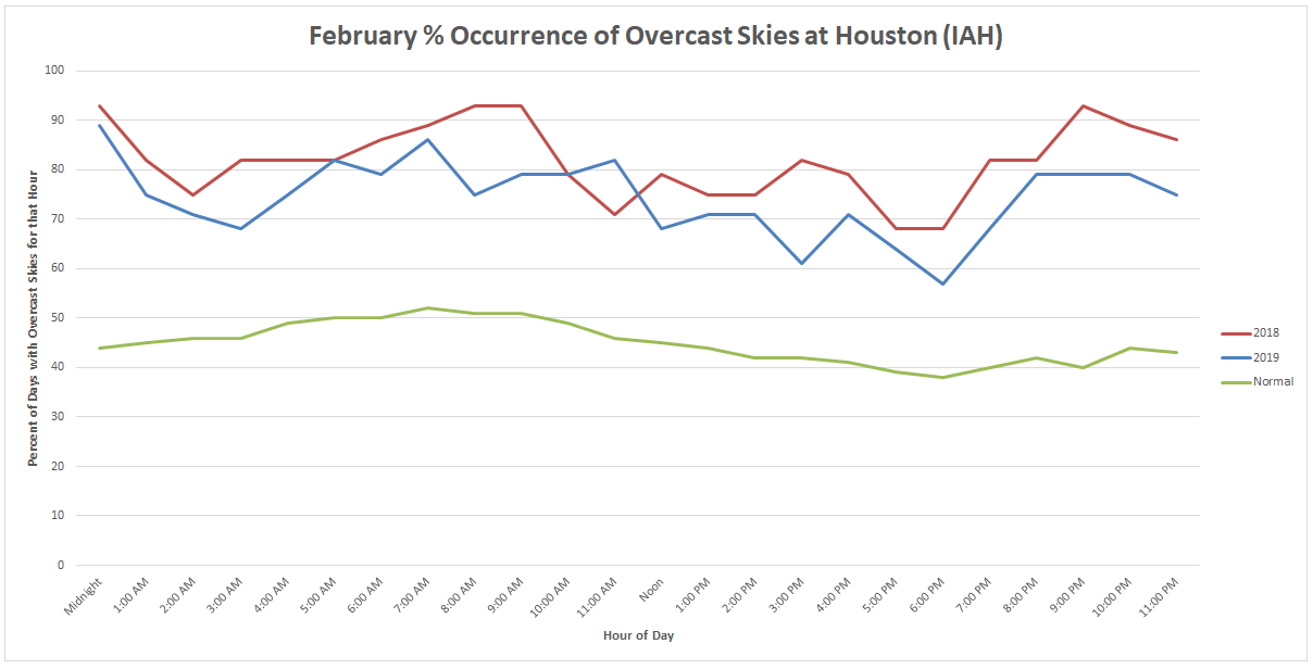
I’m going to start today’s post with a bit of controversy: February of this year wasn’t that bad of a month when you compare it to February 2018. Believe it or not, 74.3% of all hourly observations in February 2019 had some form of overcast reported. That could be fog, low clouds, high clouds, or even thin clouds with a little sunshine still getting through. But it’s a nice barometer of how cloudy the month was. Guess what? In February 2018, we managed to do 81.9% of all hourly observations in some form of overcast. So as bad as this past month was, it wasn’t quite as cloudy as last year.
February 2019 also ended up with only 1.73″ of rain officially at IAH Airport (Hobby had 3.29″). Last February saw 5.73″ of rain officially. So despite our many days of rain this year, it was actually wetter last year. But last February averaged 62.5°, while this February averaged 59.7°. So I’m giving the edge to this February for being the worse of the two months on the colder weather alone.
Today
Whatever the case, February is in the rear view mirror, and it is now onto March, which will come in….as February ended. Expect a lot of low, dreary cloud cover today. Showers are possible, but not likely. More likely will be patches of drizzle at times.
Temperatures will be the challenging part of the forecast today. That cold front from yesterday was supposed to return back north today as a warm front. That appears to not be the case, so expect a mostly chilly start to the month today. Model guidance says we will get into the low- to mid-60s later today. Given our starting point this morning in the mid-40s, I would not be shocked to see us struggle to get into the upper-50s by evening and then continue a slow rise to near 60° tonight. Either way, we’ll get there. It’s just a matter of whether it’s today, tonight, or Saturday morning.
Rodeo weather

I think we are in good shape for the rodeo tonight in terms of rain chances. Yes, I cannot entirely promise there will not be a shower, but I think that would be rather unlikely. Temperatures are another matter. Expect mostly cloudy and cool, damp conditions. Temperatures will probably be about 56-59° in the early evening and post-show temperatures should be, well, in the 56-59° range. Temps won’t move much during the evening. Watch for areas of patchy fog on your drive home, especially if you’re heading southeast of town.
Saturday
I don’t expect much serious weather Saturday, aside from areas of dense sea fog developing once again. Coastal and Bay Area communities will likely be plagued by fog once again late tomorrow and tomorrow night. The rest of us should see mostly clouds, again, though a few scattered showers will be possible through the day, especially along or north of I-10. Temperatures will continue to be difficult. South of I-10 stands the best chance at being quite warm tomorrow with highs near 75° or so. Those chances of warmth get smaller as you go north. Some places north of I-10 tomorrow may not get above the low- to mid-60s. It’s possible that at some point tomorrow Conroe is around 60°, while Pearland is sitting at 76°. It will be that kind of day.

Sunday & Sunday night
Sunday is cold front day. Look for scattered showers and perhaps a few thunderstorms anytime from mid-morning through mid-afternoon. Rain totals should be on the order of a quarter of an inch or less in most cases. A few places may see a little more. We don’t expect severe weather with the storms at this time. I expect the front to cross through Houston between 10 AM and 1 PM on Sunday. Behind it, look for about a 12-15 degree drop in temperature, from near 70 degrees into the 50s. If you’ll be out all day, you will need to dress for a couple seasons, especially south of Houston. It will also turn breezy to windy later Sunday afternoon and Sunday night.
We’ll turn quite cold Sunday night, with low temperatures likely bottoming out in the upper-30s to low-40s. Our last morning in the 30s was back on February 13th.
Next week
We will string together about three cold mornings next week from Monday through Wednesday. Tuesday morning could be the coldest.
Will we see a freeze? It’s possible outside the city of Houston on Tuesday. Any freezing temperatures will be relatively short-lived, but given that we’ve had some vegetation come out of dormancy recently, it would be wise to take some protective actions for the sensitive plants. Again, this should not apply in the city of Houston or most of the immediate suburbs, but in sheltered, more rural cold spots outside Houston (typical cold spots like Conroe or the Brazos Valley north & west of Houston for instance), you’ll want to be aware of this potential.
We break the cold on Wednesday night and start to see a return to more humid and warmer air. This could lead to more clouds, shower chances, and coastal fog late next week. More on Monday.
“Winter whiplash”… love it. Describes this season perfectly 😂
I can’t say it enough. YUCK.
Overcast 75% of the time in February? You’re making me homesick. Not really – – one of the reasons I left. It wasn’t just February. More like November thru February. Every darn year….But it will be sunny enough soon – June, July, and Ughust.
The official rain totals at IAH and HOU show how much precipitation can vary around here. I had over 4″ this week alone. I can’t cut the back yard due to all the mud.
Matt…really appreciate your report contrasting this year with last year…I’m in Clear Lake and thinking my yard hasn’t been completely dry since sometime in December…thanks to you and Eric for your service…have a pleasant day…
Well the Feb results prove it — for 2 years in a row, we were teleported to Seattle for about 28 days.
As a recent subscriber, just wanted to tell you how much I enjoy the detailed forecasts and discussions on this blog. Thanks very much for what you do!
That’s why February only has 28 days. We wouldn’t survive it if it were longer.