Yesterday ended up seeing a few more showers in the area than expected, with a couple locations picking up about a tenth to a quarter inch of rain. Otherwise, it was dry. This holiday weekend will continue to bring limited rain chances, lots of sun, and plenty of heat, as it should feel more like late June than late May. After today’s forecast, we discuss NOAA’s hurricane outlook, released on Thursday.
Friday through Monday
Each day this weekend should be similar: Daytimes will be partly to mostly sunny and nighttimes partly to mostly cloudy. While we won’t advertise rain, there could be a couple brief showers in the area, particularly Monday afternoon. You should comfortably go forward with outdoor plans this weekend though. As Eric has noted this week, just keep hydrated and take it easy in the heat.
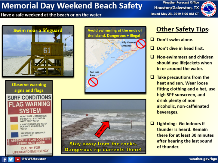
It’s always good to review swimming tips now. Rip currents will likely be an issue at times this weekend. (NWS Houston)
Rip currents will also probably be an issue at times this week on the Gulf, so it’s a good idea to do a quick review of the swimming safety tips above and always swim near a lifeguard.
As far as temps go, we will have a “back to the 90s” weekend! Look for 90° each afternoon, give or take a couple degrees. Obviously, it will be cooler along the Gulf, but even there will see mid- or upper-80s. Mornings will begin in the low- to mid-70s in most spots. Those of you out on the water will see southeasterly winds around 15 mph, perhaps gusting to 20 mph at times, especially today and Monday.
Next week
Look for continued heat and humidity most of the week. Rain chances remain on the low side for now, but there are perhaps some signs of slightly elevated shower chances as early as Wednesday, as strong Southeast U.S. high pressure begins to break down. This will allow for disturbances to edge closer to Houston by later next week. We’ll see if that actually happens, but it’s what to watch for change.
Last week’s storm system was mostly about the heavy rain and flooding, as Eric summed up nicely here. But the story that I think was most fascinating, meteorologically, was the hailstorm that hit some parts of the Houston area on Thursday night. The National Weather Service Houston office collected over 20 hail reports from the event, more than half of which were golf ball size hail or larger.
Put your car in your garage if possible or cover it with blankets. Hail pictured came down near Katy Freeway at Sam Houston toll road and the storm is headed straight to Houston. pic.twitter.com/f0prcLOuDf
Houston doesn’t often get hail this big over this wide an area. So what happened here? Why did we have so much big hail last Thursday?
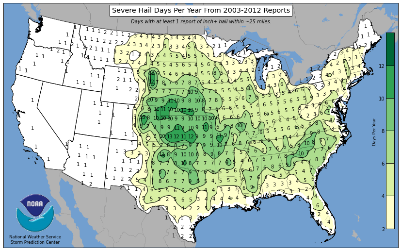
Houston doesn’t see a lot of hail
If you look at the map of annual average 1+ inch diameter hail days per year (this from 2003-2012), you’ll notice Houston is mostly on the outside looking in at significant hail reports.
Severe hail reports are most common from Missouri and Kansas into South Dakota. (NOAA)
Why is this the case? For one, thunderstorm updrafts are needed to allow for the water droplets that become hailstones to get above the freezing level. Houston is a warm place, and that freezing level is often too high and the storms not powerful enough to carry those droplets high enough for large hail to form. Our lower freezing levels occur in winter and spring, making hail more likely then. In fact, of the 62 hail reports of 2″ in diameter or larger in NOAA’s storm events database since 1950 in Harris County and adjacent counties, only 3 of those reports have occurred outside of January through May. The average hail maxima is also where it is because they simply get more powerful, supercell thunderstorms with violent updrafts in the Plains.
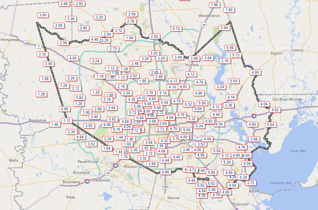
Good morning. We hope everyone is safe and doing well this morning. It has been a rough 12 hours in Houston and the surrounding area. From hail to non-stop lightning to flooding, I think we have all had enough. Numerous schools are closed this morning, including Houston ISD. Total rainfall over the last 24 hours has ranged from anywhere between 1 and about 7 inches across the region. On average, most places did 2 to 5 inches or so.
24 hour rainfall totals have ranged from 1 to 7 inches, but on average have been about 2 to 5 inches. (Harris County Flood Control)
Flooding update
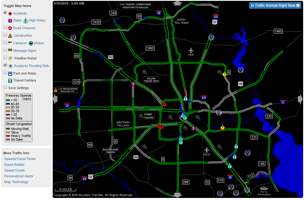
There are still numerous spots around the city and suburbs dealing with high water and street flooding. An areal flooding warning is in effect for almost the entire metro area through 10:30 AM.
As of 5:10 AM, there were still a number of high water locations on area freeways, and street flooding was still ongoing in parts of the area. Use caution and give yourself plenty of extra time this morning if you will be commuting. (Houston TranStar)
There were still a number of bayous that were either near bankfull or out of their banks. Most were southeast of the city, particularly along Clear Creek which is experiencing minor flooding between Pearland and Clear Lake. Spring Creek to the northwest is still rising a bit and is out of its banks at Hegar Road, as is Little Cypress Creek at Becker Road. Armand and Hunting Bayous have crested and will continue to slowly fall. Halls Bayou has as well, but that I-45 area near Mt. Houston is still a mess.
You can view the latest status of bayous and creeks at the Harris County Flood Control website. On the upper left, just check the dial for “Channel Status.”
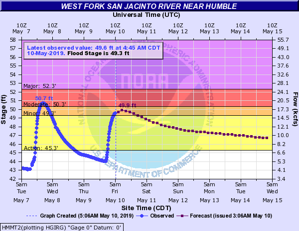
The West Fork of the San Jacinto River will crest later near moderate flood levels, or just a bit lower than the other day. (NOAA)
It will probably crest later today around a foot lower than we saw on Tuesday.
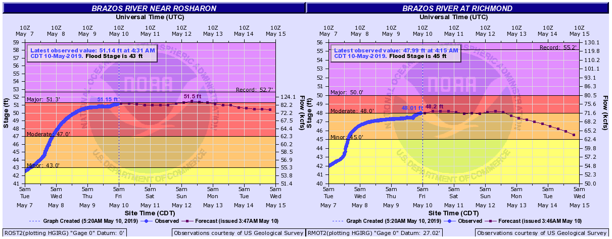
The Brazos will experience moderate to major flooding and is going to crest later this weekend about one foot or so shy of record levels at Rosharon. It will crest sometime today or into the weekend slightly less impressively, but still in solid moderate flood at Richmond. And it is going to stay high for a good time to come.
The Brazos River will likely crest by the end of the weekend at Richmond and Rosharon in moderate to major flood. The river is going to stay high for a while beyond that. (NOAA)
The bottom line: Be cautious this morning if you are out and about as there are a number of locations still flooding. But in general, conditions should slowly improve through the day.
This morning
Alright, let’s get into the forecast.
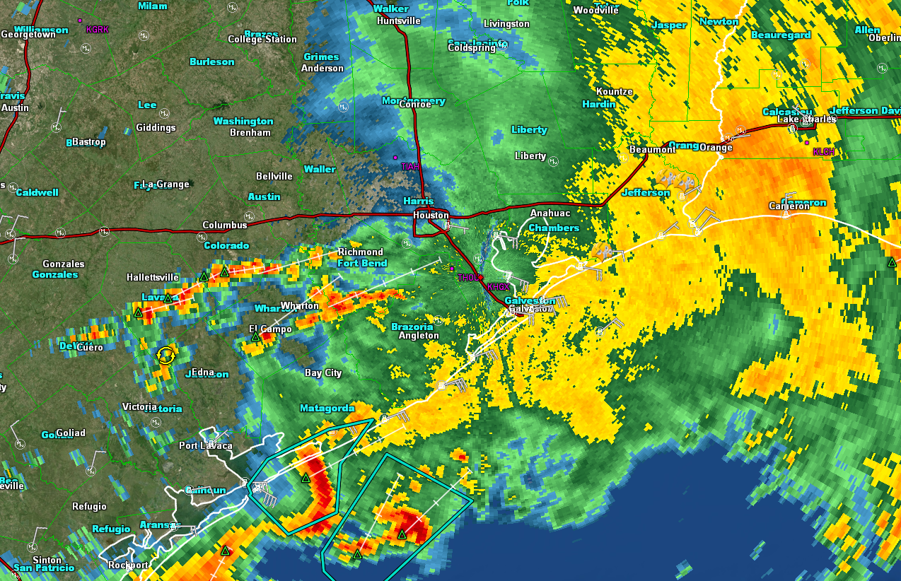
Radar as of 5:35 shows that the majority of the rain has shifted well east of the area. We are seeing new showers develop to the west and south of Houston. This isn’t unexpected, but it may mean some additional downpours over the next few hours, particularly along and southeast of US-59 from Victoria through Houston. There has been flash flooding in Galveston
The bulk of the rain has moved east of the Houston area as of 5:35 this morning. Additional showers are still possible through mid-morning. (GRLevel3)
These showers should gradually diminish and shift off to the east through the morning. There is simply very little “energy” left in the atmosphere over us to sustain new storm development. We’re tapped out after last night. So the trend should continue to be toward a drying one this morning.
This afternoon
Other than a handful of scattered showers in parts of the area, the rest of today looks quiet. We will have a chance to dry out a bit and clean up any mess left behind.
Good afternoon. We just want to offer an update on the upcoming rain situation for Houston, as it continues to look like a pretty significant event will unfold tonight over the region. If you read our post this morning, we told you that later today and tonight would be the issue. So just because it’s been dry today for most of us, don’t think this event is a bust. Things are going to change quickly tonight.
Key points
Scattered strong to severe storms this afternoon with large hail a possibility.
Weather deteriorates rapidly after 7 PM this evening, and if you can stay home for the balance of the night, it is advisable.
1-4″ of rain on average tonight with some pockets seeing 4-8″ or more.
Rain may end after 2 AM or so, leading to a dry start to Friday.
More rain to come tomorrow night and Saturday.
Next few hours/severe weather
There are a handful of downpours across the region today, but thus far, nothing significant has developed. Through about 4-5 PM, we should see this kind of story continue. After 4-5 PM, weather modeling is in good agreement that more numerous storms will begin to pop up. Given that the atmosphere has had all day to destabilize (and it has done so rather considerably), any storms that form late this afternoon will be capable of large hail and strong winds. Isolated tornadoes cannot be ruled out either.
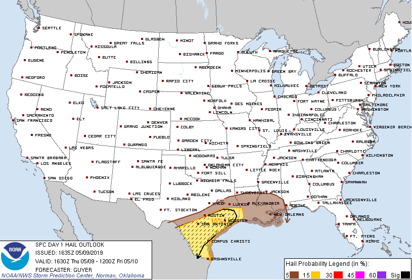
The Storm Prediction Center is outlooking Southeast Texas for potentially significant hail this afternoon, should any storms get going. (NOAA)
Severe weather is a distinct possibility anywhere in the area this afternoon and evening, but especially south and west of Houston. In fact, the Storm Prediction Center has us in a “hatched” area for hail risk now, which basically means that significantly large hail is possible.
Tonight/flooding concerns
I have looked at a lot of data today, and it seems to me that consensus favors a steady, significant escalation of rain after about 7 PM tonight. If you don’t need to be out on the roads after 7 PM, we would strongly advise you stay put. If you do have to be out, please make sure you have a safe route to get where you need to go, or stay put until conditions improve. Flash flooding is most dangerous and hardest to see at night. Storms will become more numerous and likely to setup over the heart of the Houston metro area, focusing along or north of I-10 initially, and then drifting slowly south as the night progresses.
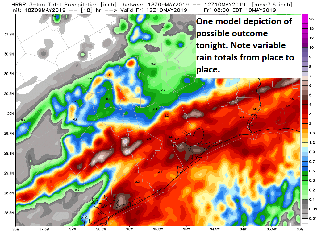
The HRRR model depiction of total rainfall tonight implies 1-4″ on average, with “lollipop” totals of 4-8″ or even more in isolated locations. This is just one possible outcome, and should not be taken to be gospel. (Weather Bell)
Rainfall rates of 1 to 4 inches in an hour will be possible anywhere in the Houston area tonight and with storms likely to track repeatedly over certain areas, street flooding is likely in parts of the city and suburbs and bayou or additional river flooding is a very good possibility as well.
The image above shows the HRRR model’s forecast of total rainfall between now and 7 AM Friday. Don’t focus specifically on what it shows for your area, but rather just note the big picture idea it shows for the region: A widespread 1 to 4 inch rain, but “lollipop” totals that are much higher. Those are the areas we are especially concerned with for something worse than just street flooding, and those could be the ones that see as much as 4 to 8 inches or even more. So that is why we are very concerned about tonight. As I said this morning, it will not flood everywhere, but it could flood anywhere in the region. We will know more about which areas those could be later this evening.
A strong boundary or front could cross through the region after about 12-2 AM or so, which should kick most of the rain off to the east, allowing most of us to dry out a bit toward morning, but at that point the damage will have been done.
Beyond tonight, we should still see at least some scattered storms tomorrow, but the focus may be south of Houston. Look for another wave to lift heavy rain and storms through the Houston area tomorrow night and Saturday, with more flooding a possibility. We will worry about that tomorrow. We will have more later this evening, as the rains unfold.