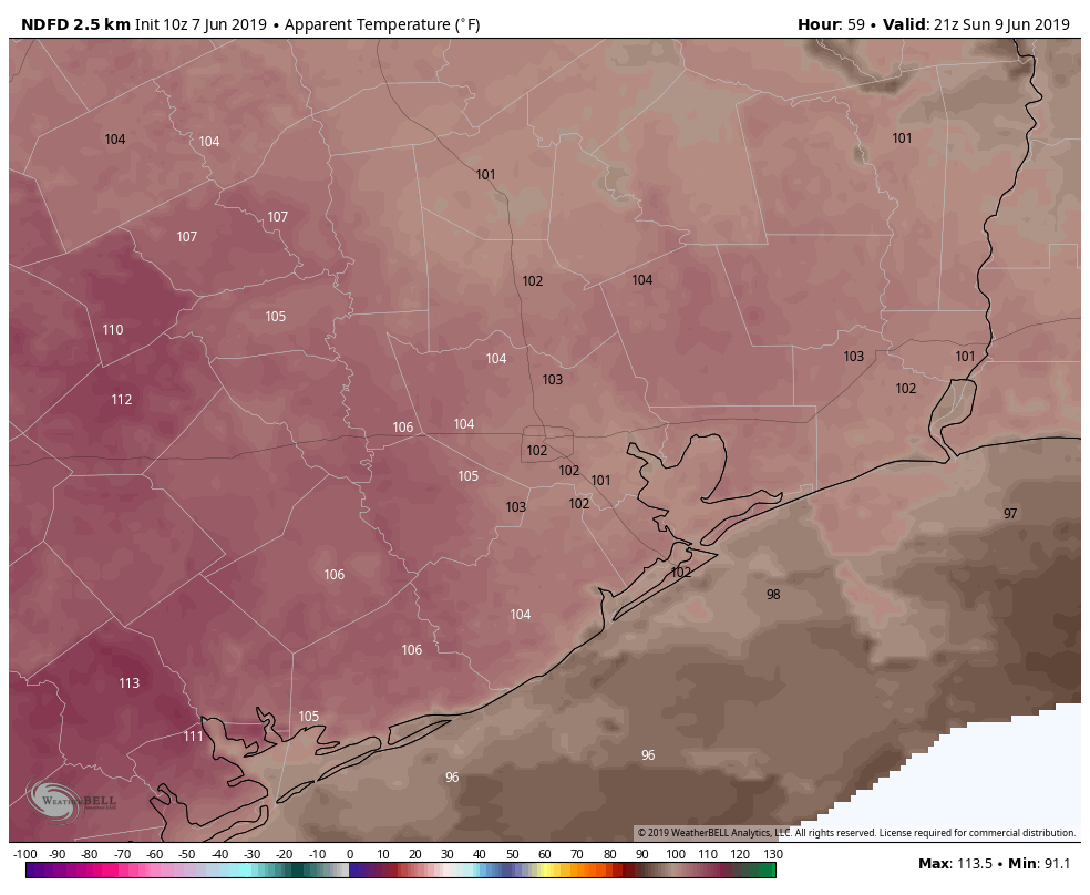
Houston’s weather story remains the same

It’s both a blessing and a curse as a meteorologist to live somewhere that you could almost set a clock to the weather each day. Predictability is great, but they say variety is the spice of life. Houston’s weather has been nothing if not persistent recently. And it looks to continue heading into the next several days.

Today

I don’t see a ton of difference between today and any other day we’ve had this week really. But there are enough subtle differences to make me fairly confident we see more showers around today than we did yesterday. Precipitable water (“PWAT,” a measurement of how much moisture is available in the atmosphere) is flat or down just a bit today versus where it was on Thursday in Houston. PWAT remains elevated north of The Woodlands and east into Louisiana today. While it could rain anywhere as we go into this afternoon, the best odds of cooling downpours will probably be near the coast or Galveston Bay this morning and east of I-45 or well north this afternoon. But regardless of where you’ll be in the Houston area, have an umbrella at the ready today.

Here’s a model derived radar forecast from 12 PM-8 PM today showing widely scattered showers flaring up, especially east of I-45 and to the north of Houston. But that certainly won’t exempt Houston from storm chances today! (Texas Tech)


Temperatures will range from the low to mid-90s where rain is minimal to the upper 80s or lower 90s where downpours are more persistent.

See full post

Fleeting showers ease Houston’s sizzle

Houston is off to its tenth hottest start to a July on record (matching July 1-6, 1931 for #10), with an average temperature of 85.9° so far this month. It hasn’t been extreme heat by our standards, but it’s been steadily hot and humid. A bunch of folks saw some cooling showers on Thursday, and as we kick off the weekend, a few more will see some relief as well. But don’t count on substantial, prolonged relief anytime soon. Summer is in control. Let’s walk through it.

Today & Saturday

Fairly similar weather is expected both for today and tomorrow. Expect a few showers near the coast in the morning (you can see those on radar this morning), expanding and spreading inland during the afternoon.

Radar this morning shows a few downpours near the coast. Expect these to expand and move inland as the day wears on. (GR Level 3)


While coverage will likely not be widespread, I do think a good chunk of the area will see at least a shower. A few others will see downpours. And a few others still will just have to stare longingly at dark clouds in the distance, hearing the thunder of relief that has passed them by. Alas, Houston in the peak of summer can be cruel in that way.

Rainfall totals will obviously vary, with some places seeing squat, while others under a more persistent downpour could see one or two inches of rain. Shower coverage should be slightly greater on Friday than Saturday.

Expect high temps today and Saturday to be perhaps a touch cooler than they have been running thanks to better coverage of showers than we’ve seen lately. Some will see low-90s. If you aren’t fortunate enough to see a shower, you’ll probably do mid-90s.

See full post

Summer set to sink in

Eric’s post from yesterday covered most of what’s about to unfold over Houston for the next week or so (and, really, the next couple months for that matter). Summer is here for real. So just some details here.

Friday Through Tuesday

No big changes to speak of here. We should see a few showers in the area today, but almost certainly nothing like we’ve seen the last several days.

Forecast radar today shows a scattered bit of mostly minor showers through the day. (Weather Bell)


It should be more like a smattering of small afternoon downpours in spots than the numerous scattered thunderstorms like we’ve been dealing with. The rain chance drops off a cliff Saturday though. Basically, Saturday through Tuesday look to be about the same: Partly to mostly sunny, hot, humid. I wouldn’t completely rule out a downpour on any of those days (particularly Monday or Tuesday), but the chances are so small, it really isn’t even worth discussing right now.

The rinse and repeat pattern Eric mentioned yesterday also applies for forecast temperatures. Houston should top off around 93-95° each afternoon, with morning lows generally in the mid to upper 70s. If you’re heading to Galveston, a similar story of consistency, with roughly 89-91° each day and lows a bit warmer thanks to the warm Gulf, coming in around 80° each morning.

Beyond Wednesday

Agree with Eric yesterday: Not much change is in store. The pattern looks pretty stable over Texas at least. Expect pretty persistent temperatures. Rain chances may go from like 10% early next week to 20% each afternoon later next week, but I don’t see things getting much worse than that even out toward next weekend at this point. We’re in a quiet period now.

The tropics look quiet in the Gulf and Caribbean as well.

The tropics are quiet in our backyard for the foreseeable future, as the Gulf and Caribbean are void of much moisture and disturbances. (NOAA)

No real signs of anything worth discussing over the next 7-10 days or longer. The eastern Atlantic has seen some aggressive tropical waves early this season, but at this point it’s still a bit early for anything to get moving. If we continue to see these sorts of waves in a month, it will be something to monitor. But for now, breathe easy and enjoy a hot (but quiet) Fourth of July weekend!

Posted at 6:30 AM by Matt

Unsettled summer weather settling back in

With Cindy in the rear-view mirror, we’re tracking back to a more standard but unsettled summer weather pattern. No serious trouble is expected the next few days, but if you’ll be outdoors this weekend, you’ll want to have a rain plan. Let’s break it down.

Today

The main story today is going to be unpleasant temperatures. Highs should reach the lower or middle 90s in Houston and the upper-80s at the coast. But in the wake of Cindy, humidity is going to be oppressive. Dewpoints at Galveston may hover around 78-80° most of tomorrow. When you factor that humidity in with temperatures, it will feel gross. Heat index values will be quite high today, so you’ll want to take it easy outdoors.

Model forecast of heat index at 4 PM says it will feel like around 105° in most areas, Hotter west. Limited relief at the coast. (Weather Bell)


The National Weather Service has heat advisories posted today for Wharton, Colorado, Austin, Grimes, and Brazos Counties, as well as the cities of Austin, Dallas, Waco, and San Antonio.

In terms of rainfall, today should carry the lowest risk of the next several. If I were placing odds, I’d give it about a 10% chance of a rogue downpour, mainly this morning and mainly southeast of the city.

See full post