A lot to get to today, but the big headline this morning is that Saturday’s forecast has changed. You’ll want the jacket handy.
Today
As of now, we think that, while we will have scattered showers around today, the majority of the daytime should be under control in Houston and points south and west, as capping (which helps inhibit thunderstorm development) will likely be in place much of the day. So at this point, we aren’t expecting anything too serious during the daytime. However, as you go north and east of Houston, a few more organized, stronger storms may get going this afternoon.
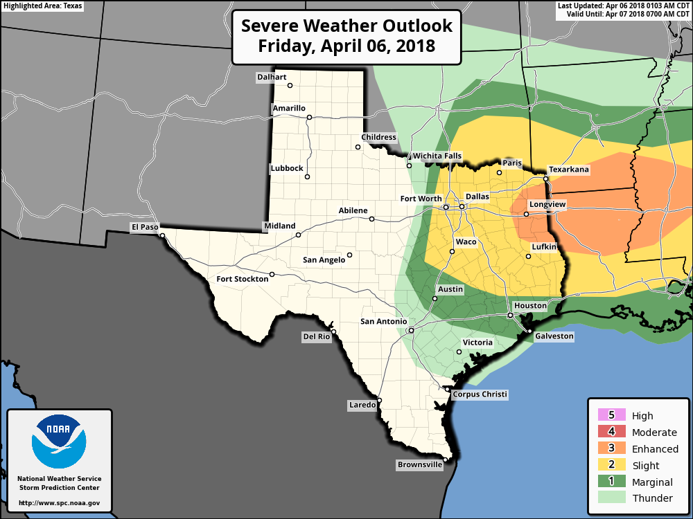
For that reason, the Storm Prediction Center has placed counties north and northeast of Houston in “Slight” (or level 2) risk for severe weather. The most volatile ingredients for severe weather today will again be in far northeast Texas or northern Louisiana. But we can’t rule out a few strong to severe storms northeast of a line from about The Woodlands through Port Arthur. We’ll keep tabs on this today in case anything changes.
Tonight
The cold front, well to our north today, will advance south into our area overnight tonight, probably well after midnight. One difference with this front versus the last couple we’ve had come through overnight: Whereas the last couple fronts timed in the 10 PM to 2 AM window, this one will likely be later, say, 2 to 6 AM-ish. So, you may be woken up later in slumber by a rumble of thunder.
Between today’s showers and storms and tonight’s front, rain amounts may be a bit variable across the region.
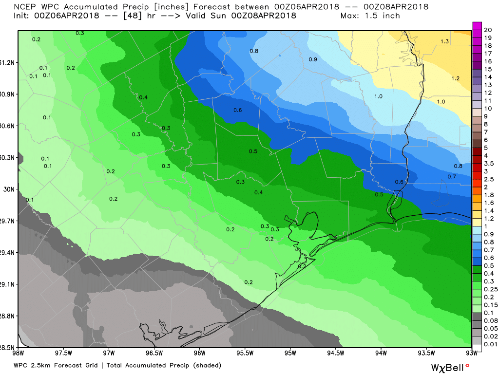
On average, I think rain amounts will be a few tenths to half an inch in most places. Some of us may get a little more (perhaps 1-2″ or so with some thunderstorms today). Some places south and west of Houston may only see a small amount of rain. We don’t have any serious flooding concerns from this system.

Weekend
Get the jacket ready, because late winter is coming.
Behind the front early Saturday morning, expect a few showers to linger. Those should end in Houston and north, but they may linger at the coast into the afternoon. I wouldn’t be surprised if it’s low clouds and mist in a few places for a good chunk of Saturday morning and afternoon. However, because of the extremely cold air mass for this time of year behind the front and the minimal sunshine, temperatures will peak before sunrise, and they could hold steady or drop all day. There is still some uncertainty on just how cold we can get during the daytime Saturday.
My thinking right now is that temperatures will drop quickly from the low 70s or upper 60s ahead of the front before sunrise into the low 60s or upper 50s behind it on Saturday morning. After sunrise, we’ll keep gradually dropping into the mid to upper 50s from Houston south and east and into the low 50s northwest of Houston. It may be 55-60 in Galveston and 45-50 in The Woodlands Saturday afternoon if cloud cover holds. Tomorrow night will see temperatures drop further.
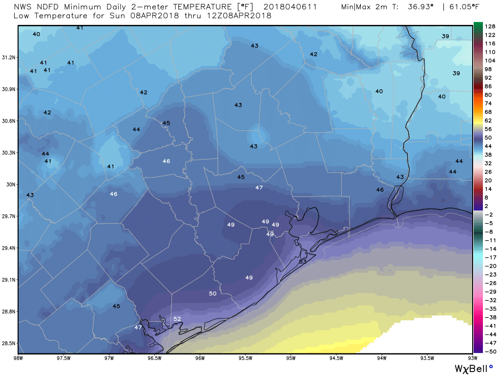
Look for 40s in most of the area for nighttime lows. I wouldn’t entirely rule out 30s up toward Conroe or Huntsville.
Sunday should be a bit nicer. We’ll have a mix of clouds and some sun. Temperatures will warm up as onshore flow kicks back in. Look for highs in the low 70s Sunday afternoon. I can’t entirely rule out a shower,sort of like yesterday, but I suspect it will be mostly dry.
Next week
After a warm day Monday, look for another cold front late Monday or Monday night to again bring a slight shower or storm chance and then cool us off. That cold air mass doesn’t look quite as significant as Saturday’s, so I don’t expect anything below mid-50s in Houston right now. We’ll have a nice pair of days Tuesday and Wednesday before onshore flow ramps back up and we warm up Thursday and Friday into the early weekend.
A chilly Saturday? No complaints here – the heat is on the way, and it won’t stop for months and months!
Absolutely No Complaints…😱
A few last days of paradise before another excruciatingly long, unbearable, Houston summer.
So, so true.
These cold fronts have been such a treat!
Any thoughts on rain chances in the Chappell Hill/Brenham area for early Saturday morning? I have an outdoor event, and would like to be prepared! You guys are the only weather people I truly trust. Thanks for all you do and bring to us!
Rain won’t be heavy (that’ll all be near the coast or south), but I wouldn’t rule out a little drizzle or light rain lingering perhaps. It probably won’t be a pretty morning, but it might be manageable. Thanks for reading!
pfft, jacket. I’ll go out shirtless in it just to FEEL it one last time
I always go shirtless
Matt, which set of showers/storms stands the better chance to be severe for those of us in Kingwood? The afternoon of overnight set?
Thanks!
Afternoon would have a slightly better chance to be severe, but the better overall chance for thunder in general is overnight. So low probability, higher risk daytime…higher probability, somewhat lower risk overnight.
Kind of a random specific to me question, but we are driving to Ft Worth through Waco this afternoon. Do you think this front will give us any issues driving through bad thunderstorms?
Heavier stuff should hold off there til evening. Think odds for storms go up between Waco & FW after 5-6 PM.
Just wanted to let you know how much you nailed this. We drove between two giant cells (the one to the East dropped Orange size hail at my friend’s house in Dallas) just after making it through Waco at around 6pm. Well done sir!
I’m sorry, but the drama on local weather programs is ridiculous. The cooling trend is so welcome as we head into summer temperatures and misery. Enjoy this! It’s not going to be freezing or bitter cold. It’s going to be just under room temperature and absolutely gorgeous for a very short time. Now, the folks up north suffering through snow, wind, ice, that’s cold.