Dense AM fog, then quick moving showers possible later today

Give yourself a few extra minutes out the door this morning as dense fog is hampering visibility all over the area. A Dense Fog Advisory is posted til 10 AM. Fortunately, we won’t be mired in this weather all weekend.

TODAY/TONIGHT

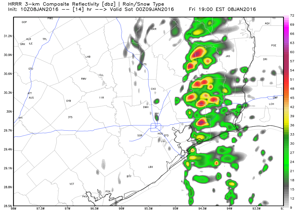
Once the fog dissipates, we should see some sunshine. But our next weather maker is going to plow through here by mid to late afternoon, allowing for clouds and showers to develop. Similar to Wednesday night/Thursday AM, this disturbance will have some vigor to it, so the possibility of thunderstorms is there. These quick moving systems hitting California and then plowing across Texas can surprise with more thunder or rain than expected sometimes. The difference between today and Wednesday night though will be that the majority of this storm won’t get organized until it’s east of Houston, so the heaviest action with this one will be east of I-45 and perhaps mostly in Louisiana. Still, just be alert for some downpours or thunder any time after 3-4 PM today.

Forecast radar for 6 PM this evening shows most activity east of I-45. Still, be on the look out for some downpours later. (Weather Bell)

Things clear out after midnight tonight.

See full post

1:30 PM Update: So far so good, but storms on the way

A Tornado Watch remains posted for Houston and areas north through 4 PM. Thankfully, we’ve only seen one brief tornado warning issued today, just to the north of Navasota. Around Houston, it’s been fine thus far.

The radar shows a broken, but gradually intensifying line of thunderstorms to our west, moving toward the western parts of Harris County as of 1:30 PM. I do think the threat for tornadoes will remain on the low side through mid-afternoon.The best parameters for supercell thunderstorms are shifting to the north and east of Houston now, and while we could conceivably see a storm spin up a brief tornado, the best odds for that are moving into Louisiana.

1:30 PM radar shows a line of thunderstorms organizing west of Houston. It will move through over the next few hours. (NOAA)


That being said, with a developing line of thunderstorms, we could see strong, damaging straight line winds become an issue as it organizes moving through the region. So, remain weather aware with a method to receive weather warnings this afternoon. In addition to the severe weather, heavy rainfall is occurring in these storms. Some areas may see 1-2″ in a short time, so localized street flooding will be possible into this evening.

Temperatures drop 20-25 degrees behind the front. (Weather Underground)
Temperatures drop 20-25 degrees behind the front. Winter is coming. (Weather Underground)


Oh, and it will turn sharply colder after the line of storms to our west arrives. Temperatures may drop 25 degrees in an hour as the front arrives this afternoon. It will be in the low to mid 50s just about everywhere by evening.

So in sum: Tornado Watch still posted, but highest threat is shifting away. Strong to severe thunderstorms likely mid to late afternoon with heavy rain and gusty winds. Turning much colder as the front moves through.

Tornado Watch until 4 PM for most of Houston

The National Weather Service has gone ahead and posted a Tornado Watch for most of Metro Houston until 4 PM. It includes the City of Houston and points north and west. The watch does *not* include Matagorda, Brazoria, Galveston, or Chambers Counties. Everyone else, however, is under the watch. A Tornado Watch means that the atmospheric conditions are favorable for severe thunderstorms that could produce tornadoes over the next several hours. The best chance of tornadic storms will be north of I-10, but I would advise that if you live in Houston, keep an eye on the weather.

A Tornado Watch includes most of Southeast Texas through 4 PM. (NOAA)

Showers and thunderstorms have been impacting the area mostly west of I-45 and north of I-10 all morning. Thus far, everything has behaved nicely. That may begin to change as the cold front edges closer and we turn warmer and more unstable.

Obviously, with the tragic tornado event in the Dallas area last night, many folks will be a little extra on edge today. While the setup here in Southeast Texas is not as robust as it was in Dallas yesterday, it is still quite conducive for strong to severe thunderstorms and definitely the possibility of a few tornadoes. Whether you’re under the watch or not, you’ll want to have a method to receive weather warnings today and if a Tornado Warning is posted for your location, have a designated place to shelter in. No reason to panic, but certainly best to be prepared. We’ll be monitoring things throughout the day.

A little more autumn weather through Saturday

So another winner of a day is on tap for Friday: Lots of sun and highs actually a couple degrees cooler than we saw yesterday. Saturday should be similarly nice, with just a few high clouds perhaps later in the day and highs in the low 60s.

SUNDAY

No real serious weather worries are expected here, but we will start to notice significant changes. Dewpoints should slowly creep up from the 50s into the lower 60s later Sunday. We’ll also add a good bit of cloud cover to the mix with temperatures back up near 70°.

See full post