On the local front: All remains calm and quiet. We continue to see optimal weather to help us dry out and continue picking up the pieces after Harvey. This weather will last well into next week. Either later this weekend or on Monday, we’ll probably have to talk a bit about some potentially hotter temperatures by mid to late next week. In the meantime, the weather looks delightful for September in Texas through the weekend. Otherwise, the eyes of the weather world are focused on Irma (and also Jose, which is taking an unfortunate track near the Caribbean). Let’s start with the latest on Irma.
Irma Now
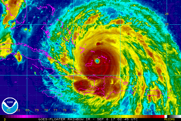
In the last 18 hours or so, Irma has been undergoing some internal reshuffling (in meteorology speak, an eyewall replacement cycle and probably some land interactions) that has caused its maximum wind speeds to drop a bit. It’s now a category four storm with maximum sustained winds of 155 mph. This is actually quite common for storms of Irma’s character. What’s been so uncommon about Irma has been its reluctance to see any fluctuations in intensity until just recently. So for all intents and purposes, Irma is now behaving like a typical high-end, major hurricane.
Irma continues to present a near-perfect appearance on satellite. This is a healthy hurricane. (NOAA)
Irma is currently west of the Turks and Caicos Islands and just north of Baracoa and Guantanamo, Cuba. It continues to move north of due west and should just graze the coast of Cuba today.
Hurricane and storm surge watches and warnings have been posted for most of South Florida.
Harvey was an incredibly emotional forecast that challenged many of us in ways we’ve never been challenged before. In writing this personal retrospective I sought a way to process this experience and convey the emotion of the last couple weeks in words. So this is my story, my call to action, my open letter to the city I’ve come to love.
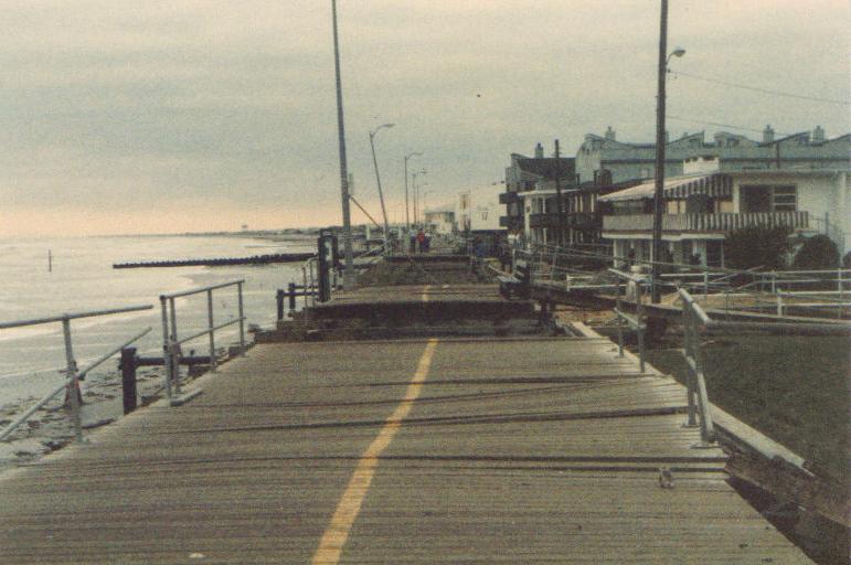
I grew up in New Jersey and became fascinated by weather, most likely at the age of three. The memories are broken up and fuzzy now, but they’re firmly in my mind. In 1985, Hurricane Gloria came barreling up the Eastern Seaboard, forcing my family to evacuate my grandmother from her home in Atlantic City. My dad taped up windows around our house about four miles inland from the shore. I remember going to the coast after dark as the storm pulled away to (perhaps my parents would now admit, unwisely) “assess damage” to the beach. Gloria’s impacts on the Jersey Shore were modest. My grandmother’s house was unscathed, and life got back to normal in short order. Somewhere along the line Gloria ignited a passion for meteorology. It started with a hurricane in New Jersey, and as I sit here 32 years later, I openly wonder if a rain-laden hurricane in Texas is what extinguishes it.
Boardwalk damage in Ocean City, New Jersey from Hurricane Gloria. (Wikipedia)
I’ve dealt with a few stressful forecasts in my career. There have been blizzards when I worked in Upstate New York. Hurricane Irene in 2011 had me considering telling my parents to evacuate the same home we shored up for Gloria. In 2012 came Sandy. I had many friends and family members back in Jersey and New York directly impacted by that storm. The lead-up to that storm was one of the most stressful I’ve dealt with, though now a fading second to Harvey. At the time I worked as a meteorologist for the energy trading arm of Deutsche Bank here in Houston. My boss was on a required two week leave, and the onus fell on me to prepare our New York City office for Sandy’s impacts. I remember conference calls, and giving a worst-case scenario forecast I didn’t really even grasp. Sandy was the storm that, as a passionate weather geek, I drew on a map as a kid that wasn’t ever supposed to happen. It was difficult to see the Jersey Shore, my homeland, so ravaged. But my life had brought me to Houston by then, so there was a buffer there to reduce the storm’s emotional impact. But it remained difficult to watch.
Life had indeed brought me and my wife to Houston. We moved here in 2012 after stops in Jacksonville, Southern California, and Upstate New York. Maybe it’s because I somehow grew up deep in Philadelphia Eagles territory as a Warren Moon and Houston Oilers fan (not kidding here at all, I have the 1990s-era Starter jacket to prove it), but I have always had an affinity for Houston. I had no family here, and the first time I visited was on a job interview in 2008. As a broadcast meteorologist in Upstate New York, I had decided that the route I wanted to steer my career toward involved the energy industry. After discussing it over a long period of time with my wife (then fiancée), we decided that Houston would be our goal. It took a few more years, but we arrived in 2012, a year or so after my wife’s brother moved here. My wife’s parents wouldn’t be far behind. Houston didn’t become a home. It became our home.
Sunday, 7:50am CT— Labor Day weekend rolls on and so does our mostly quiet weather. Given what’s needed for relief and recovery efforts across the region, this about as good a forecast as you could hope for in early September.
Today and Labor Day
Expect similar weather both today and tomorrow to what we’ve been seeing the last couple days. It should be mainly sunny, hot, and humid both days. High temperatures will top off in the lower 90s in much of the area. Morning lows will be in the low-to-mid-70s. We did have one or two very isolated showers around the area yesterday, and I suppose we could do the same today and tomorrow. But for the most part, the odds strongly favor you not seeing rain through Monday. Also, air quality will remain stagnant, so you’ll continue to notice haze in the area.
Tuesday and Wednesday
Gulf moisture begins to increase on Tuesday, ahead of our midweek cold front. As this happens, we should note a few more showers and storms in the area Tuesday afternoon and evening. Again, this won’t be serious stuff, and there’s a better chance that most of you won’t see rain.
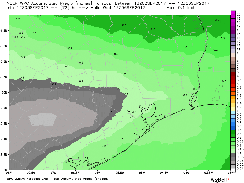
Total rainfall through Wednesday morning’s frontal passage should average a quarter of an inch or less. (NWS/Weather Bell)
In fact, total rainfall through Wednesday morning should be about a quarter inch or less on average.
The front passes through the area from north to south Wednesday morning or afternoon, ending the rain threat and dropping dewpoints (humidity) from the 60s and low 70s into the comfortable 50s!
Tuesday, 2:05pm CT— Good afternoon. Another dreary day across much of the region as Harvey (finally!) begins to slowly pick up some speed and pull away. Thankfully the Houston area has seen minimal additional rains today, with most places across the hardest hit spots earlier in the week at or below one inch of new rain. Today’s hardest hit location is clearly Galveston.
Now and Tonight
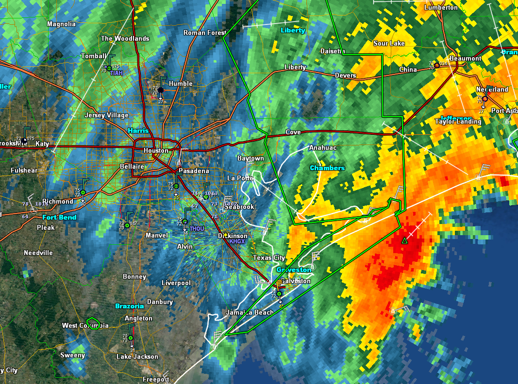
Harvey is a shell of what it once was, but it’s trying to take up a new lease on life as it leaves our area.
Harvey trying to reorganize a bit as it begins to exit the region. (GR Level 3)
Harvey has been hammering Galveston all morning with heavy rain over 7″ total today, along with strong winds. Gusts over 50 mph have occurred at times on the island. This will continue as Harvey pulls away, but with a slight downward trend eventually.
Rains have really cut back around Houston, which is great news for us. Our neighbors to the east are unfortunately now in a serious predicament with extremely heavy rain pointed at the Beaumont and Port Arthur area. These areas have been similarly battered by rainfall since the weekend. Heavy rains will lash that area through this evening, worsening a bad situation. Some additional rains may redevelop tonight over Houston, but around the city, rain totals today will be the lowest they’ve been since at least Saturday.
Tomorrow and Beyond
Harvey is on its way, and it will make landfall late tonight or tomorrow morning likely in Cameron Parish, LA or near Port Arthur. We should see rain risk trend downward tomorrow with just a few showers, mostly in the morning and amounts should be mainly inconsequential as it relates to flooding. Skies may not clear out completely, but many of you will see sunshine tomorrow I project. We will stay dry into the weekend before at least some rain chances (hopefully mostly scattered stuff and nothing too organized) returns to the picture after Labor Day. We’ll have more on that once we dust ourselves off after Harvey’s exit.