A blustery walk into the weekend in Houston

As Eric promised yesterday, winter is not yet over folks. Stepping outside today, you’ll notice it feels a bit more like January perhaps. And while we do have warmer weather on the horizon, it’s pretty evident that winter is not quite ready to pack its bags just yet. At the bottom of today’s post, I’ve got a quick update on a some “polar vortexy” things that may be on your mind.

Today

“Blustery” is the word of the day. Winds are going to pick up this morning, and as temperatures stall a bit later this afternoon in the 50s, you’ll notice a little chill to the air.

Wind gusts of 25 to 35 mph at times today will give the air a bit of a chill, especially later today as temperatures hold mainly in the 50s. (Pivotal Weather)

Northerly wind gusts may exceed 20 to 25 mph at times on land and over 30 mph along the coast (where a wind advisory is posted) and over the water.

Tonight

Winds will stay up some tonight, and temperatures behind today’s cold front will drop into the 40s and probably the 30s in many spots too. The wild card tonight will be how far west clouds are able to pivot. While they probably won’t have a gigantic impact on what you notice tonight, they will likely mean the difference between 40 to 45 degrees for a nighttime low or 35 to 40 degrees, where skies are clear.

Nighttime lows from the Houston National Weather Service office will be split somewhat east vs. west due to cloud cover, with 30s more likely west of I-45 and 40s more likely to the east. (NWS Houston)

Weekend

The weekend looks great for any plans you may have. Sunshine will dominate Saturday and Sunday with highs in the mid-50s Saturday and low-60s on Sunday. Morning lows will be in the 30s once more tomorrow night with a light freeze possible in spots north and west of Houston especially.

Next week

The weather is going to be a bit chaotic next week from a pure day to day perspective. In terms of impacts, we don’t see anything too major right now. We have two fronts that look poised to push through the area. The first would come Tuesday after a warm and humid Monday. After a brief cooldown Wednesday, we’d warm up late and into Thursday in time for the next front. Much like today’s front, this one has been flagging a bit of wind with it in various model guidance, so that’s one thing we’ll watch for Thursday afternoon. Behind that front, we’d turn rather chilly Friday and Saturday again. We will sort the details out for you further on Monday.

Stratospheric situation

We are beginning to get some questions about the potential breakdown of the polar vortex over the next couple weeks, with the thesis generally being that as the polar vortex weakens from the top (stratosphere) down (surface), it unloads colder air from the polar regions into mid-latitudes, where most of us live. Or as some misleadingly qualify it: “The polar vortex is coming.”

The catalyst for this would be a sudden warming of temperatures in the stratosphere (or SSW as many of us refer to it). The Washington Post’s Capital Weather Gang had a good piece on this yesterday with quotes from some experts I follow on social media. It may or may not be paywalled, but the general gist of things is this: There is a sudden warming of the stratosphere over the polar regions, thousands of feet above the surface. It fractures the otherwise stable polar vortex in the stratosphere. A process begins that gradually works its way from the stratosphere into the troposphere (where we live) that could begin a domino effect of perhaps reshuffling the weather pattern in the Northern Hemisphere in such a way that favors colder weather over warmer weather as we head into March.

Temperature anomalies in the stratosphere on day 10 show a lot of warmth over the Arctic. This could begin the process of disrupting the polar vortex and allowing more cold to emerge into Canada and the U.S., but historically these events are tricky to predict. (WeatherBell)

“Could” does not mean “will.” Nothing is guaranteed, as not all SSWs are created equal, and not all of them lead to a configuration supportive of cold in the Central & Eastern U.S. Researchers are still working to fully understand the factors involved in these types of events that happen every few years, so we still have a lot to learn before we can start discussing anything with confidence. In other words, neither Eric or myself or anyone knows if we’ll see some significant colder weather next month. That being said, as we head into next week and the week of the 20th, it will be interesting to see what the models start showing for the pattern over America. We’ll have a decent idea if this SSW has a meaningful impact on cold risks for the country later next week or early the following week I think. So stay tuned, but if you love cold, keep your expectations somewhat in check.

Let there be sun, Houston! Soon.

The last time Bush Airport reported anything other than overcast or broken overcast skies was back on the morning of January 27th. That week-long streak will end at some point today. Most of the area will see at least some sun, if not full sun before the end of the day, and everyone sees sunshine tomorrow. In addition, we’ve gone over 100 straight hours below 50 degrees, not a particularly big deal, but it has certainly been cold and quite damp. That should end today also. All in all, if you have weekend plans, you can confidently go forth with them.

Today

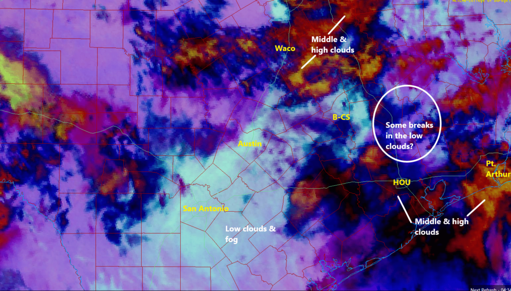
Most of the area remains under low clouds this morning. You have to get east of about Wallisville and Anahuac or west of Flatonia on I-10 to get into clearing.

Satellite as of 7 AM shows that clouds still dominate, but they will lose ground as the day goes on, allowing the sun to take hold. (College of DuPage)

The clouds will erode through the day today, allowing the sun to emerge. I think they’ll probably dissipate from east to west through the morning and afternoon. Areas most likely to stay cloudy most of today are probably west of Houston. Once the clouds diminish, look for temperatures to rebound into the 50s over most of the area. Places that stay under clouds may only get close to 50 degrees. Winds will be light in most spots but perhaps a bit gusty over the open water.

Weekend

Both Saturday and Sunday should feature more sun than clouds. Winds will flip back onshore on Sunday, which may allow for a few extra clouds. So Saturday will start chilly, with 30s in most of the area, but we should warm to near 60 or so. But Sunday will start in the 40s and warm to near 70 degrees.

Saturday morning low temperatures should bottom out in the 30s in most places away from the immediate coast. (Pivotal Weather)

Just a quick note: Models do predict some fog may develop tonight north and west of about Cypress. Anyone in places like Navasota into Bryan or College Station and north toward Huntsville, just be advised that there could be temperatures at or below freezing with fog. That could make travel a bit slick late tonight and early Saturday morning. Once the sun comes up, it will improve quickly. This should not affect the Houston area.

Early next week

Monday should be partly to mostly sunny and warm. You’ll notice a little more humidity creeping back through the day, and there may even be some patchy fog development on the coast. Most places will top off in the 70s. Tuesday should be even warmer despite more clouds, with AM lows in the 60s and daytime highs around 75 or a few better in spots. Again, some fog is possible along the coast.

Next front

Consistent with Eric’s post yesterday, it looks like we can pencil in the next front for Tuesday night or Wednesday. The timing and details still need to be sorted out, but at this point we are looking for showers and storms in some window between Tuesday night and Wednesday afternoon, followed by cooler, drier air to close out next week. Or at least that’s the line of thinking we’re going to sell to you today. Some models bring back rain chances as soon as Friday, so we’ll see. More on Monday!

Rest of Texas

Interior Texas can continue to thaw out today and begin to assess and repair the damage left behind from this week’s ice storm. There are still nearly 250,000 customers without power across the state. If you plan to travel toward Dallas or Austin or San Antonio or El Paso, road conditions should be clear today through the weekend. As always, check with drivetexas.org for the latest information.

Periods of heavy rain and thunder could lead to street flooding Sunday across the Houston area

Good morning. We just wanted to offer a Sunday post for a couple reasons. First, obviously, after this week’s storms, we know a lot of people are going to be sensitive to the mention (or sound) of thunderstorms. Secondly, we have more confidence in today’s forecast.

What’s changed since Friday? Honestly, not a whole lot. We’re getting areas of heavy rain, as expected. But I think both confidence and intensity of heavy rain has increased enough for us to place the area under a Stage 1 flood alert on our flood scale.

We have already seen parts of western Harris County, which were hardest hit this past week in terms of rain see over 2 inches of rainfall. The Weather Prediction Center has kept much of the area under a slight risk (level 2/4) of excessive rainfall for today.

Most of the area is under a “slight risk” of excessive rainfall today. (NOAA)

Basically, given Tuesday’s rain, the fact that today’s rain is performing or overperforming to this point, and the shorter-range model guidance for the rest of today, we felt it necessitated an upgrade in messaging. So, please watch for areas of street flooding, especially across western Harris, northern Harris, southern Montgomery, Liberty, and Chambers Counties today, east to Beaumont.

Expected rainfall today from the NWS. Some areas have already seen close to these amounts, so this is why we emphasize that these maps should be taken as an “average” forecast. Rain totals could reach 3 to 5 inches under the most persistent heavy rain bands today.

Radar as of 8:35 shows numerous areas of heavier rainfall, especially near Liberty and Cleveland, as well as across northern and western Harris, Montgomery, and Wharton Counties.

Radar as of 8:35 shows widespread areas of heavy rainfall. Street flooding remains the biggest concern today. (RadarScope)

With a front essentially crawling across the area today, repetitive rounds of storms are likely, and that’s why we have the flooding risk. Rain tapers to isolated showers this evening.

Severe weather

We want to be clear about today’s forecast. Two things can be true simultaneously: 1.) Some of the storms later this morning or this afternoon could be strong to severe. 2.) This setup looks absolutely nothing like the one that caused Tuesday’s severe weather and tornado outbreak.

The entire region is outlooked in a marginal (level 1/5) risk for severe weather today. Very isolated strong to severe storms are possible, but this setup is nothing at all like Tuesday’s was. (NOAA)

This looks to be more of a classic Houston severe weather setup, with the risk for isolated cells producing gusty winds, hail, or yes, even a brief spinup. The odds of this are modestly higher east of Houston into Louisiana. I wouldn’t dwell on this too much about this today, but I also did not experience a tornado on Tuesday, so I get it. It’s a good idea to just monitor the weather through the afternoon to be safe.

Monday & Tuesday

Additional showers are possible on both Monday and Tuesday this week, but at this time, we do not expect heavy rainfall. That chance may increase later in the week, however.

The front is going to essentially stall out over the area. What that does is create challenges for temperature forecasting. I would anticipate Monday being a cool day right now with temperatures generally in the 50s. All bets are off on Tuesday and beyond. Ensemble guidance projects high temperatures on Tuesday could be as low as 50 degrees or as warm as 75 degrees. Basically, the exact location of the front will determine how warm or cool we get in the days ahead. Have your wardrobe planned for multiple seasons this week. Eric will detail this more on Monday. We will update (if needed) again later today.

A gray Saturday and a soggy Sunday morning for Houston

Before we get into the forecast today, we just want to go over some of the news from the National Weather Service office in League City from the last couple days. First off, the tornado that ravaged parts of Pasadena, South Houston, Deer Park, and Baytown was classified as an EF-3.

The tornado in southeast Harris County on Tuesday was rated an EF-3, based on damage to high voltage power towers that had been flattened, a common indicator of a tornado of that intensity. (NWS Houston)

It was the first EF-3 tornado in Harris County since 2002 (La Porte).

Two additional tornadoes have also been confirmed in the Houston area. Both were rated EF-0. One traveled about 14.5 miles from Needville through Thompsons in Fort Bend County. The other occurred in Pearland, preceding the South Houston tornado and was on the ground for a bit over 2 miles.

In Liberty County, an EF-2 tornado has been confirmed, but details are not expected on that until a little later today.

The last couple days have been mercifully placid, and we look to get one more of those before some more rain.

Today

Friday should be a mostly fine day, with intervals of sun and clouds and temperatures popping up to near 60 degrees.

Tomorrow

Clouds will really increase and thicken up tonight into Saturday. By late tonight and early Saturday morning, a few showers should begin to break out, along with periods of drizzle or light rain. We don’t currently expect Saturday to be a washout, but you’ll probably see a few raindrops in much of the area. The clouds and showers will compete with warm air flowing in from the Gulf of Mexico, so after a mild morning in the mid or upper-50s, we will likely warm to near 70 degrees. You will also notice the wind picking up some on Saturday afternoon, with gusts to perhaps 25 mph or so.

Sunday

The next in a series of systems will impact us late Saturday evening and Sunday. Look for rain to break out as a coastal low develops. This system will lack much of what Tuesday’s had for significant severe weather. We do not expect serious severe weather, but a few stronger thunderstorms are possible. That said, we have plentiful moisture available Sunday, and we will be looking for the potential of locally heavy downpours, especially in the morning. This would be most likely south of I-10.

The southeast half of the Houston area has been placed in a slight (level 2/4) risk for excessive rainfall on Sunday, meaning localized downpours could lead to some street flooding. (Pivotal Weather)

Right now, the Weather Prediction Center has the region in a slight (level 2/4) risk of excessive rainfall. We don’t expect rain quite of the intensity we saw on Tuesday, but given the wet ground, we could see some areas of ponding or street flooding emerge Sunday morning under the heaviest rain. In addition, water levels on creeks are still high in parts of the area, especially north and west of Houston, so any heavy rainfall will likely exacerbate that a bit. Expect an inch or two on average southeast of Houston, with lesser amounts as you go north and west of the city.

Conditions should gradually improve later Sunday afternoon and evening. We will top off in the 70s.

Early next week

Early next week looks dominated by this front that gets hung up over our area on Sunday. That will likely be in place through Wednesday. The problem from a forecaster’s perspective is that it’s going to wobble around. That means that there’s probably going to be a pretty annoying gradient of temperatures over the region next week, with readings ranging from the 50s to the 70s depending on the exact position of the front. In addition, rainfall will be possible through the entire period, although it looks mostly minor in nature until later Wednesday or Thursday. We should have a little more clarity on the exact daily details Sunday or Monday.

Total rainfall through next Friday morning should be 1 to 4 inches across most of the region. Higher amounts are possible in spots, especially south and east of Houston. Some lower amounts may occur north and west. (Pivotal Weather)

Next front

Our next real front of significance after Sunday will come on Thursday it appears. Expect a period of showers and storms, along with some locally heavy rain. This should usher in a slightly less active pattern and a chilly air mass in time for next weekend. We do not expect a significant freeze at this point, however. We’ll update you on that Monday (or Sunday!) as well.