Through June 10th, Houston had experienced our coolest June since 2017, with a chance to perhaps outpace that year too. Since June 10th and through yesterday, it has been the third hottest mid-June stretch on record. When all is said and done, this will end up being one of our hottest Junes on record. We are firmly in it over the next week.
Today
I am not prepared to say that our rain chances are over with just yet. There are storms offshore of Louisiana this morning, along with a couple clusters of storms riding the periphery of the heat ridge over Texas.
Storm clusters riding the periphery of the heat ridge over Texas may lead to some showers and storms, mainly east of I-45 today. (College of DuPage)
As those clusters drop south and east, complex interactions with lingering boundaries from storms in recent days could yield at least a few new storms, mainly east of I-45. I think that’s the exception, not the rule and that the intensity of the storms will (hopefully) be much less than seen the other night. So don’t bank on storms. But just know there’s a chance.
Outside of that, more of the same: Clouds, sun, a heat advisory that could be upgraded to an excessive heat warning, and plentiful humidity. Highs will be in the upper-90s.
Saturday & Sunday
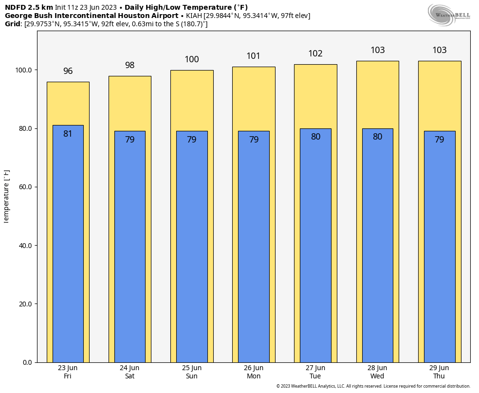
Hot. Highs near 100, lows near 80. Rain chances decline to near zero.
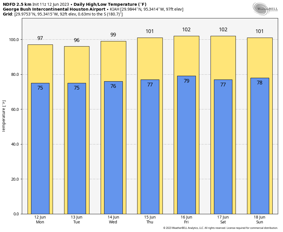
No relief is expected through next Thursday. (Weather Bell)
Next week
We will escalate the heat daily until about Wednesday or Thursday, when things should peak. This will push us into the low-100s for highs, with lows again near 80. While humidity doesn’t look *as* high as this past week’s heat, it will likely be high enough, along with slightly less wind to lead to another round of potential Excessive Heat Warnings.
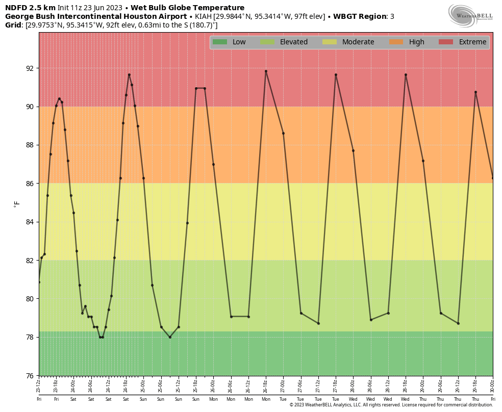
Wet bulb globe temperature is another measurement of heat stress on the body that we can use to assess the seriousness of a heat wave. In this case, it will be at “extreme” levels this weekend and next week (Weather Bell)
When we look at the wet bulb globe temperature forecast for Houston we see extreme values continuing, much like this past week. Heat index basically factors in humidity and temperature to give us a “feels like” value in the shade. Wet bulb globe (WBGT) factors in things like latitude and date to generate sun angle, wind speed, and cloud cover, in addition to temperature and humidity to generate a measurement of heat stress in the sun. What I like about WBGT is that it’s sort of a universal measurement. Once above 90, that poses extreme stress on your body, whether in Houston, Miami, or Phoenix. Houston would typically be in the moderate to high level of WBGT this time of year, so the fact that we’re in “extreme” levels speaks to how abnormally hot this is for us.
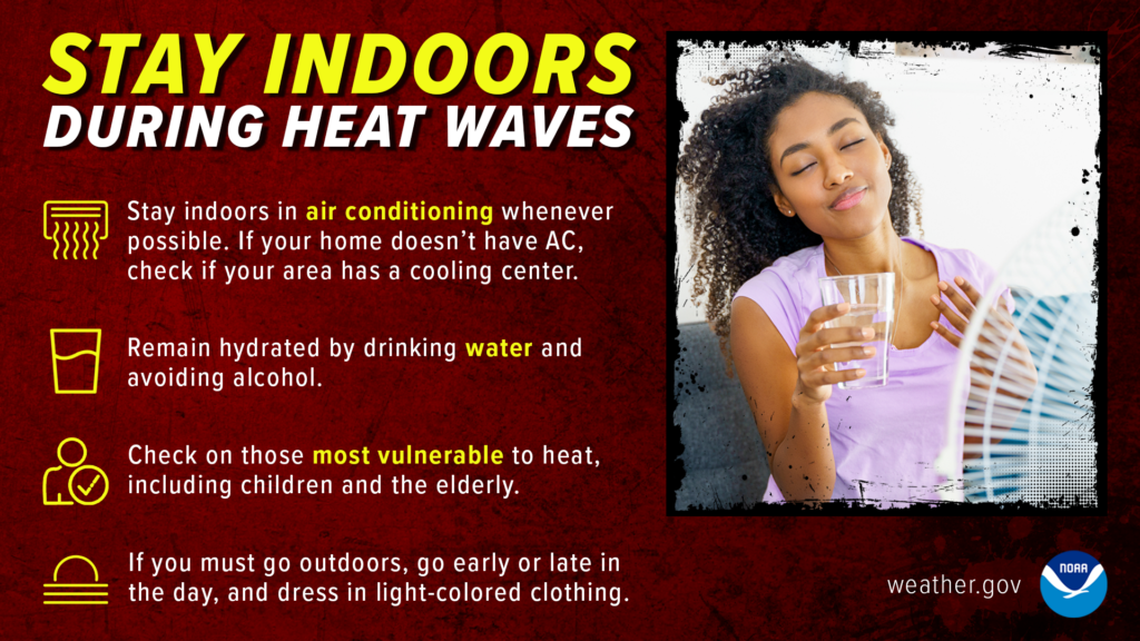
A long way of saying: Take it easy on yourself. Go slow. Drink water. Maximum heat precautions need to be fully implemented over the next week.
Hopefully the “death ridge” responsible for this heat shifts into the Desert Southwest next weekend or the week of July 3rd. Should that happen, perhaps we can resume more typical summer weather here in Houston, which while still certainly hot, would be a little less stressful on our bodies.
We’ve seen a lot of comments from folks on the site and social media along the lines of, “Well, it always gets this hot in summer and always has and this is no different so why are you making a big deal of this?” It is true: Houston is hot in summer. From May through September, you can describe Houston as hot, humid, sultry, or whatever other colorful adjective you want to use. Some may say, the difference between 94 and 98 and 100 is difficult to perceive anyway, so what difference does it make?
An excessive heat warning has been issued for Houston for the first time since August of 2016. It covers the entire region away from the coast. (NWS Houston)
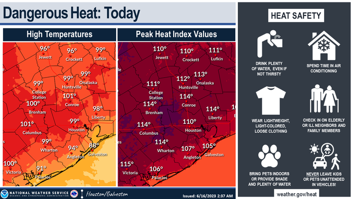
Usually about twice per summer or so, the heat in Houston goes to what I call the next level, where it’s hot like always, but it just feels worse. This is the type of heat where your body can truly suffer if you don’t take it seriously. We’re in one of those periods right now, arguably one of the worst such periods in several summers. Heat index values yesterday were all over the place, including near 115° in spots around Houston and even near 120° in spots near Corpus Christi and Port Arthur. A more typical summer day may feel along the lines of 99 to 105° or so. So this has moved into the higher echelon of next level of heat. Hence, we are trying to convey that this is more serious than normal summer heat. And it will continue for awhile longer. Please take it seriously this holiday weekend, especially if you’ll be attending any of the Juneteenth celebrations in the area or outdoors in any capacity.
We don’t want to be too preachy, but this is more serious heat than is typical for Houston. (NWS Houston)
We have energy saving tips from our sponsor and partner Reliant just below the forecast. As the heat puts stress on the grid over the next several days, these energy saving tips will come in handy.
Friday & Saturday
All we can tell you about these two days is that they’re going to be miserably hot and humid. Expect heat index values of 110° to 115° or higher, with actual temperatures near 100° inland and in the 90s along the coast. A heat advisory is posted for the coast, while the rest of the region has an excessive heat warning. The last time the city of Houston had an excessive heat warning was in August of 2016. So, again, this speaks to both the rarity of heat of this magnitude, as well as the fact that it’s June not August.
Heat index values may peak over 115° in spots today and tomorrow, meaning maximum heat safety precautions should be taken. (NWS Houston)
Let’s not forget about nighttime. Low temperatures will struggle to get much below 80 degrees each night. This sort of compounding heat can take a toll, especially on the very young and elderly. If you’re headed to the Gulf for some relief, please also keep in mind that rip currents look a bit strong this weekend, so be aware of that if you jump in the water.
Sunday & Monday
Copy and paste Friday and Saturday’s forecast and tweak the temps by 1 or 2 degrees in either direction. More heat warnings and/or advisories are a guarantee.
Rest of next week
By later next week there’s some chance that we may exit this “max heat” type situation and get back to something just regular “abnormally hot.” So instead of heat index values of 110 to 115°, maybe we fall back to more like 105 to 110° or so. It’s a maybe, but at this point, we’ll take whatever good news we can get.
In terms of rain chances, they remain near zero until perhaps midweek or late week next week, when maybe we can bump them up to 10 or 20 percent on a good day.
A Message From Our Sponsor, Reliant
As Eric and Matt have warned us, the summer heat is here. With triple-digit temperatures forecasted for the coming week, Reliant is sharing helpful tips to stay cool while managing your energy usage.
Setting your thermostat four degrees higher when you’re away from home for more than four hours can help reduce electricity usage.
Raising the temperature of your home by even a few degrees also reduces energy consumption. Every degree of cooling below 78 degrees increases your energy use by 6-8%. While the suggested temperature for ideal energy use in the summer is 78, a comfortable temperature setting is a personal preference – just know every degree makes a difference.
Rotate your ceiling fan counterclockwise for a wind chill effect. This can make the temperature in a room feel up to four degrees cooler, allowing you to be more comfortable and adjust your thermostat to save money. Don’t forget to turn off your fan when leaving the room.
Use blinds or curtains to reduce solar heat gain by up to 50 percent. Direct sunlight can increase the demand on your A/C by as much as 30 percent.
Check air filters monthly and replace as necessary. A clean air filter can keep your A/C running at peak condition.
Avoid using heat-producing appliances like the clothes dryer, dishwasher, or oven during the hottest times of day. These appliances can cause your A/C to work harder to keep your home cool.
Find additional energy efficiency tips from Reliant by clicking here.
On Monday, Houston topped off around 95°, after a 94° on Sunday and 93° on Saturday. So far at least, our temperatures seem to be underachieving a bit. That may be a bit of cloud cover or the relatively wet weather we had through late spring acting against heat. Regardless, it will remain plenty hot through the week.
Today
Today’s upper air temperatures are expected to be about 1 to 2°C warmer than they were yesterday, which should translate to a bump of a couple degrees to our high temperatures. Look for mid to perhaps some upper-90s in most inland spots, slightly cooler at the coast. Storms are expected to remain well north of the area today, but some clouds from those storms could filter into some of the region.
Heat advisories are now posted southwest of Fort Bend County and could be expanded depending on how things evolve today. (NWS Houston)
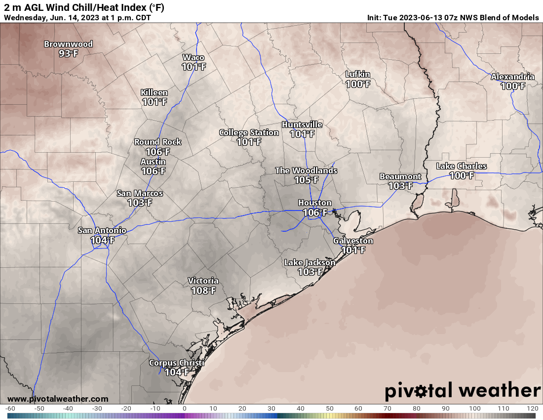
Peak heat index values (or feels like temperatures, if you prefer) will be in the 103 to 107° range in Houston, just shy of heat index criteria in most of the area. But to the west, they are expected to flirt with 108°+, requiring a heat advisory. This could be expanded later today and certainly will be as the week goes on.
Wednesday
Morning lows will be in the upper-70s tomorrow. We tack on another 1-2 degrees on Wednesday in the upper atmosphere, so look for mostly upper-90s for highs here. As seems to be the case, some passing storms well off to our north may send some “debris” clouds this way which may keep the risk skewed slightly lower for high temps. We’ll see.
Heat index values should ratchet up a little bit tomorrow as temperatures increase a bit too. (Pivotal Weather)
Heat index values will nudge up some tomorrow, with peak readings perhaps more into the 105 to 110° range, which could yield wider coverage of the heat advisory.
Thursday through Sunday
No changes to the forecast here with minimal rain chances (model probabilities are under 15 percent all days) and a mix of sun and clouds each day. High temperatures will likely be in the upper-90s most days with at least a chance at 100+ officially. But admittedly, after yesterday I am not as convinced we do that. But, whether it’s 100+ or not, we will likely see heat index values average in the 105 to 110° range on all days, meaning we will potentially put together a string of heat advisory days, so make sure you’re keeping cool and drinking plenty of water.
We still cannot confidently answer when this heat will start to relax. Maybe later next week.
Tropics
We continue to update the tropics daily over at The Eyewall, and we have little to discuss right now! Good news for sure, and with this dry, hot air mass dominating Texas and the western Gulf, we’re very much in the clear for the next 7 to 10 days. Look for a larger feature at The Eyewall tomorrow that goes in depth on what has been happening in the Gulf of Mexico in recent years.
After a couple rounds of some gnarly storms on Thursday and Saturday, the region should be in for a fairly durable break over the next several days. However, the cost will be the strongest heat since last summer. It makes for a fairly simple weather forecast, but there are at least a couple things to note. Since every day looks to be about the same, we’ll discuss things a little differently today.
How hot are we talking?
Forecast highs today through the weekend look to be in the upper-90s to low-100s each and every day. There is probably a slightly higher chance of 100+ as we get closer to the weekend as the upper level ridge of high pressure that’s causing this heat flexes a bit more.
The NWS forecast as of Monday morning through the weekend shows escalating heat this week, with the hottest coming Friday and Saturday. (Weather Bell)
Models indicate about a 70 percent chance of hitting 100° during the peak of the heat (expected Friday through Sunday), with about a 35 percent chance of hitting 103° and a 15 percent chance of 105° in Houston. We get hot in summer here in Houston, but this is sort of the next level of heat. Morning lows will be in the 70s to near 80 each day.
How bad will the humidity be?
The humidity will be about as bad as you typically see in Houston in summer. There’s nothing about this air mass that’s overly impressive in terms of humidity right now. Dewpoints will be running near to maybe just a little above average. So, you’ll feel the humidity for sure, but that’s typical for our area. However, with abnormally hot weather to go with that humidity, it sets us up for escalating heat this week.
As of right now, the National Weather Service does not intend to issue heat advisories for the Houston area today or tomorrow, but that will probably change later this week when we start testing that criteria (heat index, or “feels like” values of 108+ or air temperatures of 103+) a little more. Excessive heat warning criteria features heat index values of 113° or higher or air temperatures of 105° and up.
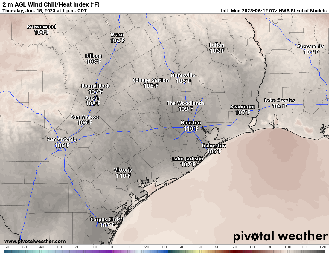
The forecast for heat index values on Thursday afternoon shows 110° for a “feels like” temperatures in Houston, which would easily place us in heat advisory criteria. (Pivotal Weather)
Initially, expect afternoon heat index values of 103 to 107°, worst in and south and east of Houston, escalating to near 110° or hotter by late week. Whatever criteria we do or do not hit, it will be important to take it easier than normal in the afternoon heat. The NWS Houston office has a handy web page with graphics and information on heat safety. Look before you lock, drink water, wear sunscreen, and try to stay cool.
Will anything make this more tolerable?
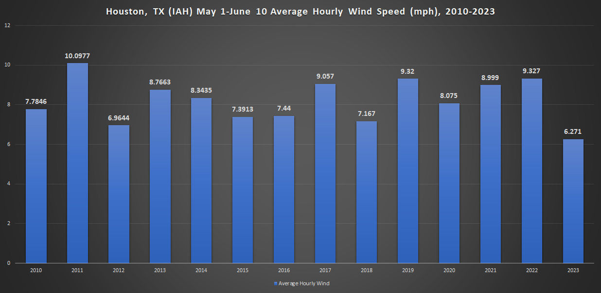
If you’ve been paying close attention since May, you may have noticed a real lack of wind around these parts. We had some pretty windy months earlier in spring and also last spring. But since at least 2010, no May 1st through June 10th period has had a lower average wind speed in Houston. Relative to recent years, it’s been dead calm. That is finally changing this week.
The average hourly wind speed in Houston since May 1st has been the lowest for that period since at least 2010, with only May 1-June 10, 2012 coming close.
We expect wind this week to average about 10 to 15 mph or so, with occasional daytime gusts of 20 mph. While that won’t make it feel nice with temperatures this hot, it will take a bit of the edge off. It’s a bit counter-intuitive, as this sort of heat is typically associated with what we derisively call a “death ridge,” a hot, dry, calm atmosphere. But we’ll be downstream of it at least initially, so we benefit with some wind.
How about rain chances?
Those will be mostly absent. I would say that if you live north of Houston, up toward, say Huntsville or Madisonville, you have at least a chance at getting grazed by some storms that will pass across North Texas this evening, Tuesday morning, and Wednesday morning. Model guidance from the National Blend of Models (NBM) shows about a daily peak of 10 to 15 percent chances of measurable rain over the next 7 to 10 days for Houston, and maybe 15 to 20 percent up north of Huntsville and Walker County. Chances look absolutely paltry south of I-10 right now. So, no, it does not appear we will see much, if any rain over the next week.
If you look at a loop of the weather pattern 20,000 feet up (500 mb level) over the next 10 days, you see a lot of horseshoe-like curvature to the black lines over Texas, indicating high pressure is firmly in control through that period. (Pivotal Weather)
If you look at the weather pattern about 20,000 feet up over the next 10 days (looped above), you can see that the ridge flexes this weekend (indicated by a horseshoe-like curvature to the black lines over Texas) into early next week. We call this a “persistence forecast,” where every day is basically mostly like the previous day. What that means is we’ll likely be dealing with high temperatures of 97 to 103 degrees over the next 10 days. I will caution that there’s always a chance we can’t see a disturbance or something that can throw a wrench into a persistence forecast like this. But right now, I certainly don’t see what that catalyst would be. After midweek next week, it does appear that the ridge may retreat to the west some, which could allow for a bump in rain chances and cooler weather.
Stay cool, and we’ll be back with an update on Tuesday morning!