Good morning! Memorial Day is starting off with some downpours south and east of Houston, and that will become more common as the day wears on.
Isolated showers have developed south and east of Houston on Monday morning. They will expand north and west through the afternoon. Click to enlarge radar from 9:15 AM. (RadarScope)
Some of these showers have been heavy, producing as much as 1 to 2 inches of rain over the last hour at Kemah, for example. Additionally, there have been reports of waterspouts over the bays and Gulf. Just stay aware if you’ll be on the water today.
As we move into afternoon, watch these showers expand north and west. Not everyone will see rain, but those of you that do may see a healthy amount in a short time, in addition to lightning. If you hear thunder today, make sure you get indoors, as periodically, storms like this can produce lightning rather far away from the storm itself. Those that see downpours today could pick up 1 to 2 inches or even a bit more. Others will see nothing.
Storms should subside after sunset, but I am thinking we’ll see a little continued activity north and east of Houston for a time, while new showers will probably develop after 1 to 2 AM near the coast or bays. More scattered showers and storms will be likely tomorrow, but again some will get a soaking, while others get nothing.
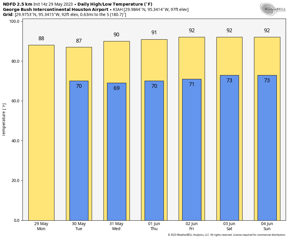
Temperatures after Tuesday look to average near to slightly above normal for Houston, while humidity will be near to slightly below normal. (Weather Bell)
The forecast for the rest of the week looks pretty calm, less rainy than it appeared a couple days ago. Temperatures will be in the 80s the next two days, but by Wednesday we’ll probably be back to 90 or better each day, with lows in the 70s. That said, the humidity continues to look at or slightly below normal, so while hot it may not be quite as oppressive as usual heading into early June. More tomorrow. Enjoy the day!
We start today’s post off by wishing everyone a safe and pleasant Memorial Day Weekend, and as we honor those that have fallen in defense of our freedoms, we thank those who have served and are currently serving our country today.
Simply put: The weekend looks great with nothing worse than a “typical” chance of PM showers, particularly Sunday and Monday. Next week looks a touch more interesting, but we’ll cover that more in depth Monday.
Friday through Monday
The period between now and Monday looks pretty steady state. Expect plenty of sunshine and highs near 90 each afternoon. Morning lows should be in the upper-60s to low-70s. Humidity won’t exactly be low, but it will not be oppressive by Houston standards.
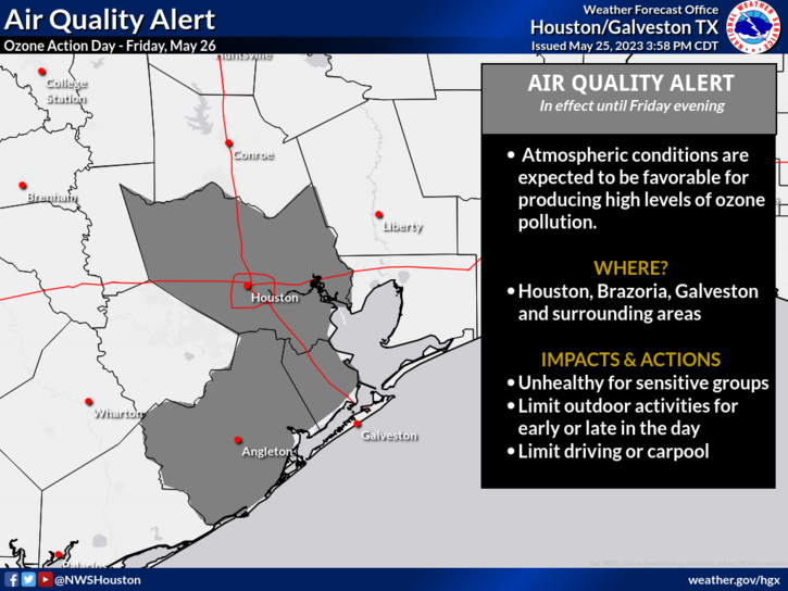
Friday is an ozone action day, and it’s possible we will see more of this through the weekend, with conditions unhealthy for sensitive groups to ozone. (NOAA)
We’ve been dealing with ozone action days most of this week, and today will be no exception. Lots of sun and lots of traffic means lots of ground level ozone. Those sensitive to high ozone levels will want to take it easy today and probably again this weekend too. We may also see a little haze as some lingering wildfire smoke from both Canada and Central America may come back toward us this weekend, but hopefully it will be clearer than we saw earlier this week.
In terms of rain? We’ll go for a requisite 10 percent or so chance of a stray shower today and tomorrow. Sunday, we could bump those chances up to 15 or 20 percent, and by Monday they could be more like 20 to 30 percent. Most areas will likely stay dry through the weekend, but just know that Monday carries the highest chance of a wetting shower in the area. As a result of slightly higher rain chances, Monday could be a couple degrees cooler as well.
Next week
After Monday, things become a little more unsettled with some disturbances swinging through. This should allow for slightly cooler temperatures and slightly higher rain chances from Tuesday into Wednesday. Additional shower chances may arrive toward next weekend.
The 8 to 14 day outlook for Texas shows slightly higher confidence for below average temperatures, allowing summer to start on a relatively mild note for our area. (NOAA)
Overall, the pattern over Texas is likely to remain cooler than average and perhaps wetter than average over the next 10 to 14 days. We will see how long that lasts. Look for an update on Monday morning to set the table for next week. We will also share some thoughts on hurricane season next week as well. Enjoy the weekend!
We eked out a 90 degree day on Thursday, and we’ll look to do it again today, as early summer starts to assert itself. That said, the humidity will remain fairly tame over most of the next several days, especially away from the immediate coast. All in all, about par for the course for late May.
Today
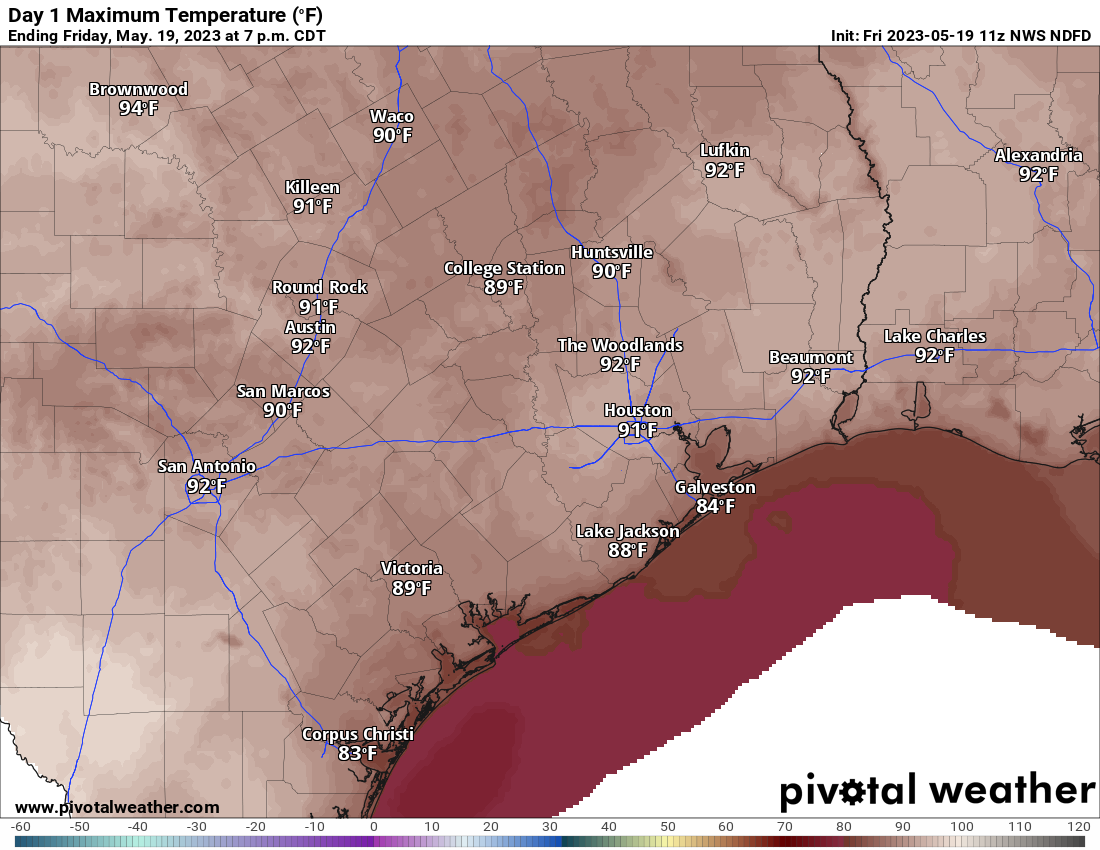
We’ll have plenty of sunshine today. Look for high levels of ozone as a result, so air quality may be a bit poor this afternoon, especially for those of you that are in a sensitive group for ozone. High temps should approach or exceed 90 degrees in many spots away from the coast.
High temperatures will range from the mid-80s in Galveston to the low-90s in and around Houston today. (Pivotal Weather)
Weekend
The weekend will feature the much discussed “cool” front that should help keep the humidity in check a little longer. Of course, that does mean the return of shower chances. On Saturday, with the front sneaking into our northern areas in the morning, some showers and storms may pop up as early as the early morning. We’d likely see those dissipate rather quickly and then some new isolated showers or storms develop in the afternoon or evening elsewhere in the region. We’d anticipate that most areas won’t see anything too crazy Saturday. A few communities will see a downpour, however.
Hit and miss showers may continue after sunset Saturday and into Saturday night, especially west of the Houston area, probably closer to San Antonio. Again, nothing major is expected, but if you have outdoor plans, maybe have an umbrella at the ready just to be safe.
As the front kind of washes itself out overhead on Sunday, we should see scattered storms across the area, focused in Houston or possibly points south. While we again don’t expect any significant issues, there could very well be a couple downpours in the area Sunday. The slight edge for outdoor plans goes to Saturday this weekend over Sunday. We aren’t expecting any big ticket totals, but a couple areas may see up to an half-inch or so of rain, while others see nothing at all. I’m keeping my expectations rather in check this weekend based on the latest data, but as always, prepare just in case a few showers or storms pop.
As far as temperatures go, we foresee upper-80s to low-90s Saturday and slightly cooler temps Sunday (low-80s) due to clouds and some of those possible showers. Morning lows should be around 70 degrees.
Early next week
Once we get to Monday, most of the impetus for driving showers and storms will have vanished. That being said, with some clouds and a good bit of sun, we could still see some showers or isolated storms, mainly south and southwest of Houston.
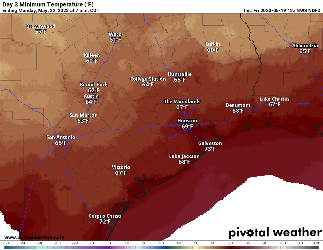
Borderline pleasant morning lows will greet you on Monday morning, with 60s away from the coast. (Pivotal Weather)
With the slight drop in humidity in the wake of the front, we will probably see lows mostly in the 60s to start next week. Daytime highs will still be plenty warm, with mid to upper-80s Monday and Tuesday. Tuesday’s rain chances should again be mostly focused south and west of Houston and on the lower side in general.
Later next week
I think Wednesday and Thursday carry greater coverage of showers and storms than we see Monday or Tuesday and closer to Houston proper. These storms would likely come from the east in Louisiana and be capable of some heavier downpours, thanks to a weak “backdoor” cold front. Temperatures may hold in the mid-80s here. We might get a very slight reinforcing shot of drier air behind that front to keep humidity levels in check another couple days into the weekend. But thereafter, summer should begin to flex, with warmer nighttimes (low to mid-70s) and daytime highs at or above 90° daily by the end of Memorial Day Weekend.
It’s a bit early to speculate much on the holiday weekend, but as of right now there is nothing that stands out in terms of higher rain chances or extreme temperatures. We’ll check back in on that next week.
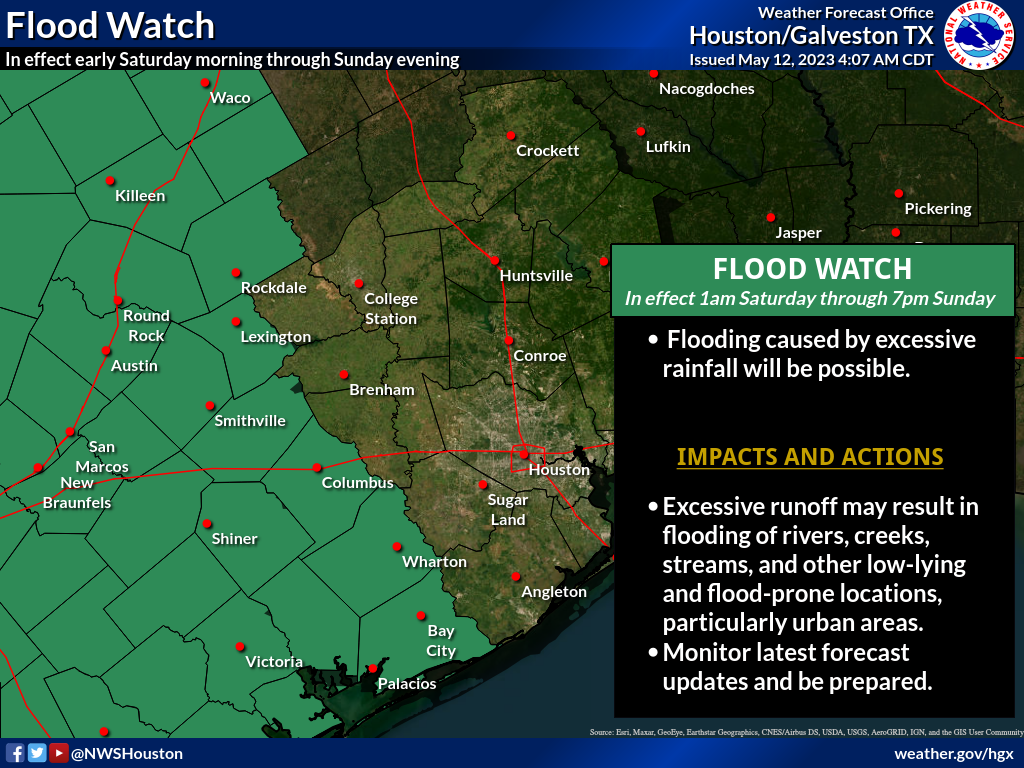
As promised, yesterday ended up being much, much calmer, giving us a chance to exhale and dry out a bit. Things are going to pick back up again as we head into the weekend — but probably not for everyone. We continue to see a pretty healthy split in the weekend outlook, with areas west of Houston more likely to see more rain than the Houston area itself. As a result, the National Weather Service issued a Flood Watch for areas southwest of Houston for the weekend.
A flood watch is in effect this weekend for Wharton, Jackson, Matagorda, and Colorado Counties west and south of Houston. (NOAA)
Those areas under the flood watch are the most likely areas to see multiple rounds of heavier rain this weekend. Areas not under a flood watch (which is most of Houston) are likely to see at least some showers this weekend, including the risk of some heavy rain. But it would most likely be manageable. That said, Eric and I will be monitoring the weather this weekend, and we’ll post an update or two if necessary or if things change, which I would caution is possible.
Today
Of the next several days, today looks calmest. Yes, there will probably be at least a few showers or storms around this afternoon in parts of the area. But those will probably be the exception, not the rule. Look for a good deal of clouds this morning, yielding to sunshine with highs well into the 80s, if not near 90 degrees.
Saturday & Sunday
I wanted to split these days up in the forecast to try and give you a better idea of what to expect each day, but the pattern over the state of Texas this weekend is far too chaotic for me to try and time anything out specifically.
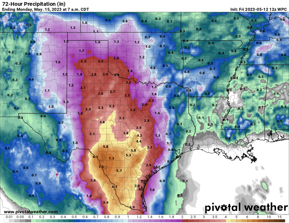
Here’s the deal: If you have outdoor plans this weekend, have a backup plan indoors if needed. If your plans take you west of Houston (Austin, San Antonio, Hill Country, the Valley, you will likely run into thunderstorms at some point, including the chance of heavy rain, severe weather, and flooding. Be aware of what’s happening out that way and do your best to avoid flood prone areas if possible.
Rainfall this weekend should average an inch or less in the Houston area, with amounts as high as 4 to 8 inches out toward Austin, San Antonio, and in the Rio Grande Valley.
Total rain this weekend across Texas will be highest in the Rio Grande Valley through San Antonio, with high amounts into Hill Country as well. Exactly who sees the most rain is TBD. But these areas need it with widespread drought in west and central Texas.
For us in Houston, while we don’t want to be overconfident, it would appear that Saturday afternoon or evening may carry the highest risk of storms making their way into the metro area. Sunday should, should see slightly lower rain chances for Houston proper and the metro area. Both days will be warm and humid with highs in the mid-80s and lows in the 70s. Outside of any storms, we may see some sunshine. But clouds may be a bit more dominant this weekend.
Early next week
The weather pattern across Texas remains active next week, with scattered showers and storms possible. It may not rain every day, but there will at least be a chance of rain each day. We still look to see a weak “wind shift” front later Monday or Tuesday. Maybe we drop humidity a tick or two, but I wouldn’t expect much more than that. Temperatures will be generally in the mid to upper-80s by day and low-70s by night.
As noted, Eric and I will be watching the weather this weekend and update accordingly, if only to help everyone strategize their weekend plans. In the meantime, to the many moms that read our site, happy Mother’s Day!