We’d like to officially welcome you to early summer today. The next several days will feel more like later May or early June than early May. Not unheard of by any means, but certainly a change from what we’ve been experiencing much of the last month or so. The humidity is likely here for awhile. The heat may wane some eventually, thanks to a potentially wetter, stormier weather pattern in Texas.
Just a quick note on the hotter weather this weekend. Early season heat can be a little tougher on the body because we have not adapted to it yet, especially after such a comfortable spring. So please take it easy on yourself outside this weekend and practice heat safety.
Today
Some patchy fog may greet you out the door this morning, but short of that, it’s quiet. Much like yesterday, the sky may look threatening at times today, but most of the day will be fine. We’ll call it mostly cloudy with highs in the upper-80s, maybe near 90 in spots with enough sunshine. Storm chances this afternoon aren’t especially high, maybe on the order of 10 to 20 percent, but anyone that sees a storm later today could see some gusty winds, hail, legitimate downpours and lightning.
Saturday and Sunday
So, if you look at your phone’s weather app (including our own app!), it looks like this weekend is going to be miserably stormy. In reality, it’s not going to be that bad. Both days will feature a chance of showers or storms. But coverage of those storms is expected to be isolated. So plan for the chance of having your outdoor plans temporarily disrupted by storms, but I would not necessarily expect that to be the likely outcome. Sunday may carry a slightly higher chance of rain than Saturday, especially north of Houston.
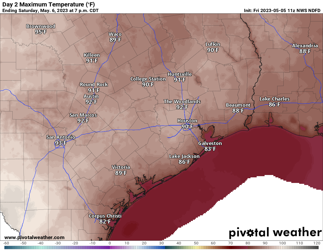
High temperatures on Saturday are expected to be near 90° or in the low-90s in much of the area. While not outrageous for early May, our bodies have not yet adapted to these temperatures, so take it slow this weekend if possible. (Pivotal Weather)
One thing I would plan on is hot weather. Saturday’s forecast highs are shown above, and Sunday won’t be much different. Expect upper-80s to low-90s and morning lows in the 70s. And plenty of humidity.
Next week
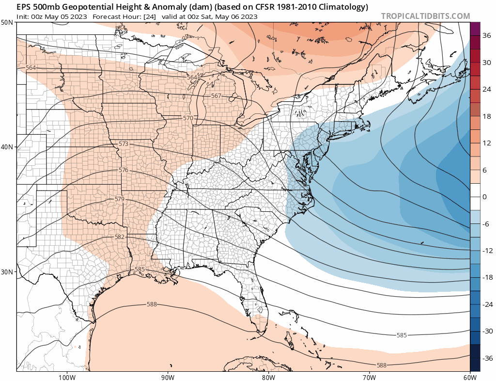
The pattern this weekend is going to feature a ridge of high pressure about 20,000 feet above us. Early next week, that ridge is going to break down. It will be replaced by more of a trough, a cutoff low pressure system, or something “flatter” over South Texas. In simple language: The pattern is likely to turn more unsettled with rain chances much of next week.
The pattern in the upper atmosphere is going to transition from a ridge over SE Texas to something more convoluted by the end of the week, leading to an increasing chance of daily showers. (Tropical Tidbits)
Given the difficulty with specifics, I would say we’d probably copy and paste a forecast of clouds, sun, a 30 to 40 percent chance of rain each day, highs well into the 80s, and lows in the 70s.
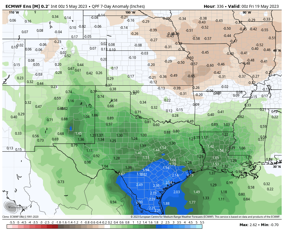
The wetter pattern is expected to stick in Texas, with models forecasting above average rain over Texas for the next 2 weeks. The map below shows the days 8 to 14 forecast rainfall anomaly from the European ensemble mean.
Models show a wetter than normal pattern continuing into the second week of the forecast, which means daily shower and storm chances are likely to stay elevated beyond the end of next week. (Weather Bell)
We’ll see if that’s the case, but if you’ve been seeking some added rainfall this spring, you may get your wishes granted.
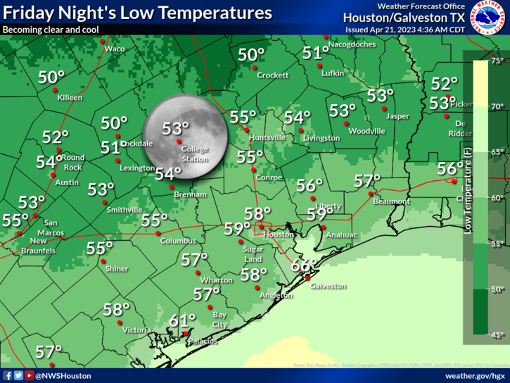
Despite the noisy storms early Thursday, we were rewarded with just a delightful Thursday evening and now a cool, pleasant Friday morning. Today looks great, but tonight may get noisy again, so mentally prepare now. But after some lingering showers Saturday morning, the rest of the weekend looks pretty great. And if you’re riding in the Texas MS 150, there’s all kinds of mixed news for you. Prepare those leg muscles.
Today
Any low clouds or patchy fog west of Houston should clear quickly this morning. Then, just spectacular. Sunshine, tolerable humidity, and highs in the 80s. Look for some clouds to begin to increase later today. Storms are not expected before evening in the Houston area at this point.
Tonight
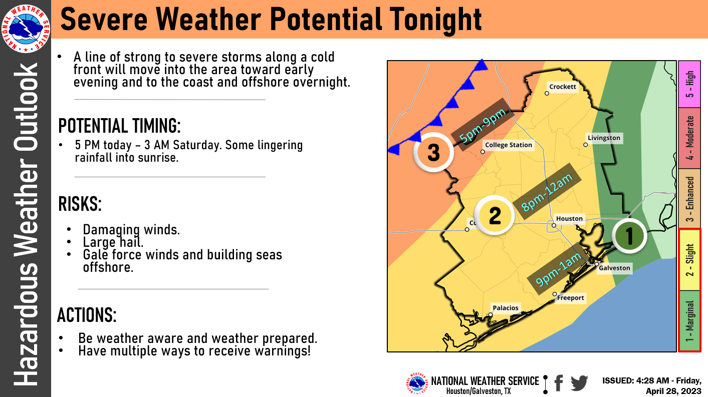
It all changes after sunset. We expect a pretty well organized line of thunderstorms to develop across the I-35 corridor, somewhat like we saw on Wednesday evening. That line of storms is expected to plow south and east toward our region after 7 PM.
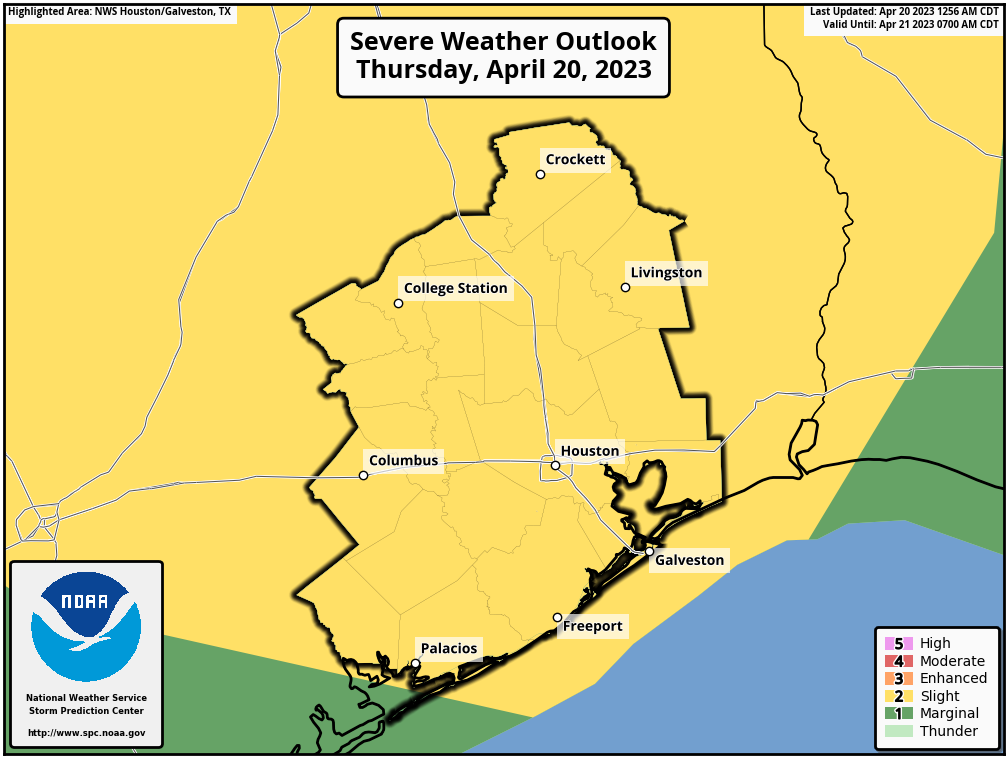
Convenient graphic from the National Weather Service Houston office showing probable timing of storms, along with the risk of severe weather. Most of the Houston area is under a “Slight” (2/5) risk, with strong winds being the primary concern. (NWS Houston)
For College Station, it may arrive as early as 5 to 7 PM, moving south and east quickly into the Houston area after 8 to 9 PM. The SPC has us in a “slight” risk of severe weather (level 2 of 5), with parts of the Brazos Valley in the “enhanced” risk (level 3 of 5). We expect a well defined line of strong to locally severe storms with lightning, thunder, heavy rain, and gusty winds (some chance of hail in the Brazos Valley). The line should weaken some as it approaches Houston. Once that initial line moves through, additional showers and rumbles of thunder (not severe) would continue into very early Saturday morning before ending after sunrise.
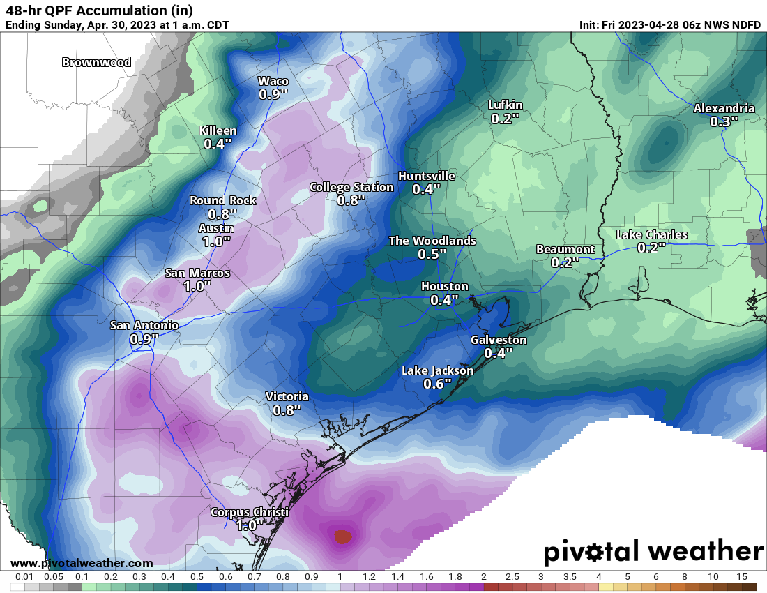
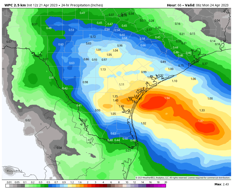
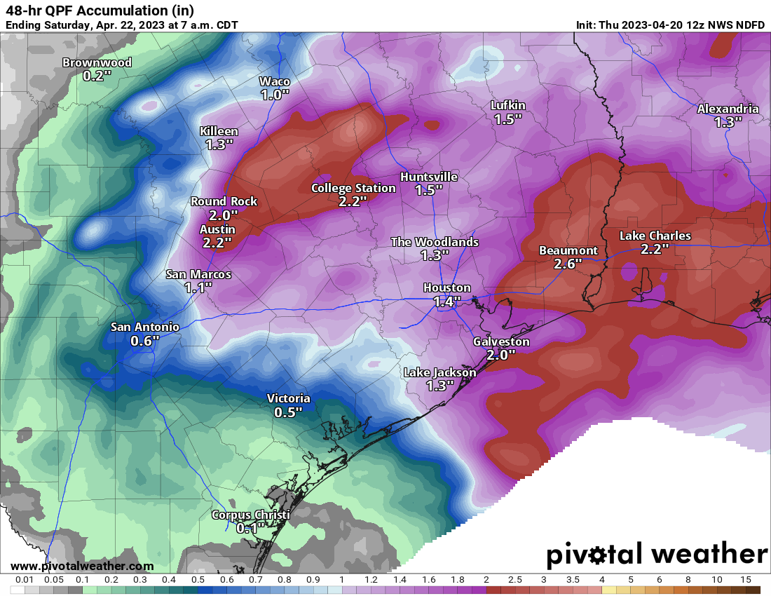
Rain totals should be a half-inch or less in most of the area, with some chance for higher amounts northwest of Houston and well south toward Matagorda Bay. (Pivotal Weather)
All in all we expect roughly a half-inch of rain or less, with some places seeing perhaps a bit more, mainly well northwest or well south of the city. Temperatures will fall into the upper-50s or low-60s.
Saturday
Any rain should clear early. We’ll probably hang onto the clouds for a few hours Saturday, but by midday the sun should be out. Saturday is going to be a bit of an odd duck for the end of April. It may feel a bit more like late winter than late spring. We’ll see temperatures probably in the 60s for most places, maybe low-70s with enough sun. Normally we see low-80s this time of year. Additionally, offshore winds are going to be cranking, around 20 to 25 mph with some higher gusts. Not quite a true ‘norther but about as close as you can get this time of year. Saturday night will see widespread 50s, if not even some 40s in parts of the area.
Sunday
Sunday should be a nearly perfect spring day. We’ll have sunshine, lighter winds, comfortable humidity, and temperatures in the low-80s, almost spot on normal for this time of year.
Texas MS 150
Alright, so if you read the sections above you know there’s mixed news. If you’re riding in the MS 150, here is the quick rundown.
A wicked headwind Saturday, much less wind Sunday.
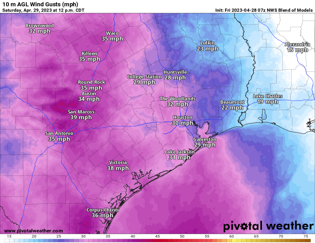
There’s no way to sugarcoat Saturday. The weather is going to be fantastic, but the wind is just going to be brutal. At times it may be more of a crosswind than a headwind, but it’s going to be coming out of the northwest or north-northwest sustained at 20 to 25 mph, with gusts to 30 or 35 mph, especially in exposed northwest facing ridges along the route.
Forecast wind gusts from the NWS Blend of Models on Saturday afternoon look strong, and they’ll be out of the northwest, making for a bit of a strenuous journey. (Pivotal Weather)
On Sunday, you’ll trade warmer temperatures for less wind. The morning won’t start that way, with temperatures likely in the 40s in La Grange. We’ll quickly warm through the 50s and 60s into the 70s by mid to late morning and eventually near 80 degrees in College Station. The good news is that wind will be much lighter, only about 5 to 10 mph out of the west.
Next week and beyond
There’s not too much notable about next week here in the Houston area, weather-wise. Expect gradually warming temperatures and increasing humidity levels through the week. We will probably level off with mid-80s for highs and mid to upper-60s for lows by Tuesday or Wednesday. Shower chances will return by then as well but right now no day looks to have particularly impressive rain chances.
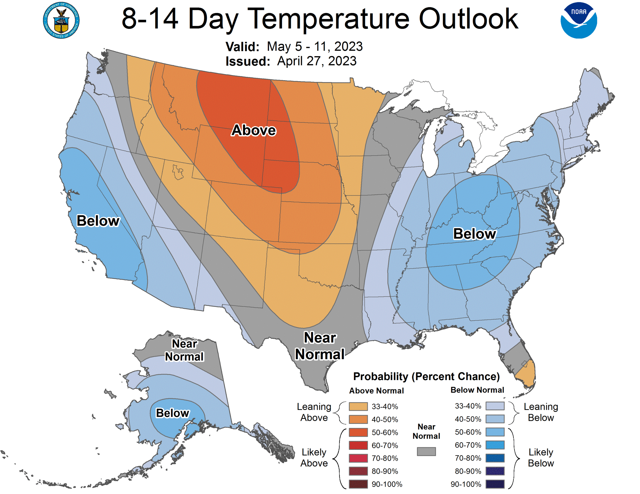
The 8 to 14 day outlook from next weekend into the week of the 8th favors cool weather on both coasts, with Texas averaging out near normal. (NOAA)
The big question right now will be whether or not we can eke out another late spring cool front sometime next weekend. The map above is the Climate Prediction Center’s 8 to 14 day outlook from Thursday. It shows a cool West and a cool East, with warm temperatures up in the northern Plains and Rockies. For Texas this time of year, these types of setups always cause us headaches. Can the cooler air get just enough oomph behind it to push south next weekend? Or will it just briefly, barely graze us and nudge off to the east quickly? If it can push through, expect another couple low humidity but mild days. If not, we’ll continue a more typical, humid late spring with rain chances. I’m optimistic we can squeeze a front through, but I also know that the odds in early May are not forever in our favor.
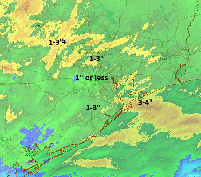
Good morning. It was a bit of a noisy night last night across much of the area at various times. Rain totals were quite variable. Most of the inner part of Houston saw 1 inch or less of rain overnight. Northern Harris County north through Montgomery County saw 1-3 inches of rain. Coastal areas got hit by a second complex of storms and saw 1 to 3 inches south of Houston with up to nearly 4 inches in Galveston.
Radar-derived rain totals from overnight match up well with observed totals with most of Houston seeing 1″, give or take, while areas south and north each saw higher totals. Click the image to enlarge. (NOAA NSSL)
You can view more rain totals from the Harris County Flood Control website. While the night didn’t go exactly to plan, the end result was mostly in line with expectations and nearly everyone saw rain.
Rest of today
The atmosphere is pretty worked over after last night’s storms, so those will actually work to help us have a mostly decent day today. I am hopeful that we see some sunshine break out this morning from west to east. We’ll then possibly cloud up again heading into the afternoon as the cold front approaches. A few showers or an isolated thunderstorm will be possible as the front passes. But I think most areas will stay calm today. We should manage the 80s for highs this afternoon, with pretty high humidity. It’ll feel a little soupy.
Saturday
Everything continues to look great tomorrow. We expect sun, comfortable humidity, and temperatures warming from the 50s (or low-60s) well into the 70s.
A cool, calm night is expected tonight, with lowering humidity and temperatures. Lows will be generally in the 50s, with 60s on the coast. (NWS Houston)
Sunday
We’re continuing to watch a vigorous disturbance for Sunday that will likely pass comfortably south of Houston. That being said, rain chances are going to build up across the area, but especially south of the city during the afternoon. These breakdowns are approximate and if you fall “on a line,” don’t read into either too much.
For the City of Houston and points north: Expect clouds and some sun on Sunday. Morning lows will generally be in the 50s to near 60, and we will warm up in the mid-70s. Humidity will be a little higher Sunday but by no means oppressive. Showers are likely to break out during the afternoon hours, especially the closer you get to I-10 or highway 59/I-69. A thunderstorm can’t be completely ruled out either.
For places south of Houston: Expect mainly cloudy skies with showers and thunderstorms developing on Sunday afternoon. Chances for heavier rain and more widespread thunder will be close to Matagorda Bay. As you go north or up the coast from there, rain chances will gradually taper from widespread to “scattered.” Some of the storms could be strong to severe on Sunday, especially as you get closer to the Corpus Christi area.
Sunday’s rain totals will be 1 to 3 inches near Corpus Christi with probably a half-inch or less on average in the Houston area. But everyone will face at least a chance of rain and thunder. (Weather Bell)
Rain will be heavy as well with 1 to 3 inches possible south of Matagorda Bay. Anyway, the bottom line is if your travels take you south of Houston on Sunday, you’ll want to be aware of this. Outdoor plans in and around Houston will clearly be a bit hit or miss.
Monday
This looks like a calmer day with just a very slight chance of showers or a storm. Look for highs in the 70s and morning lows in the 50s and 60s.
Tuesday
Details on how Tuesday will play out are fuzzy, but it’s safe to say that rain chances are notably higher versus Monday. Expect at least scattered showers and storms. It will be warmer and more humid, with highs near 80 and lows in the 60s.
Wednesday
The atmosphere may need to recover from leg day on Tuesday, so rain chances look a bit lower here. We should temps into the 80s with some sun, while AM lows struggle to get much below 70 degrees.
Thursday
Cold front day? Shower and storm chances will increase again here, as we see a cold front approach the region. Again, it’s too soon to figure out details. But it appears we’re going to see scattered storms at the least. This should hopefully setup a nice weekend for the MS150 and any other events around the region. But, we still have a few days to watch things.
The good news today is that Friday’s forecast may not be too bad at all. Yes, there will be rain chances tomorrow, but the worst of the weather should pass by early morning. The bad news is that tonight may feature midnight rain, staggered sleep, and an excitable dog index of at least eight out of ten.
Today
Today will be a bit challenging to pin down exactly. The morning looks fine. By midday, we should begin to see thunderstorms develop west of the Houston area, mainly on a line from College Station through Columbus. These storms will gradually become a bit stronger and slowly slide east, perhaps to Conroe or Huntsville south through Katy by late afternoon. By then, any storms could become borderline severe, with hail and gusty winds. Areas east of I-45 and along the coast may see little to nothing for most of today.
The entire area is under a “slight” risk (level 2/5) of severe weather today and tonight. (NOAA)
By evening, we’ll see scattered showers and storms pretty much along or northwest of Highway 59/I-69.
Thursday evening and overnight
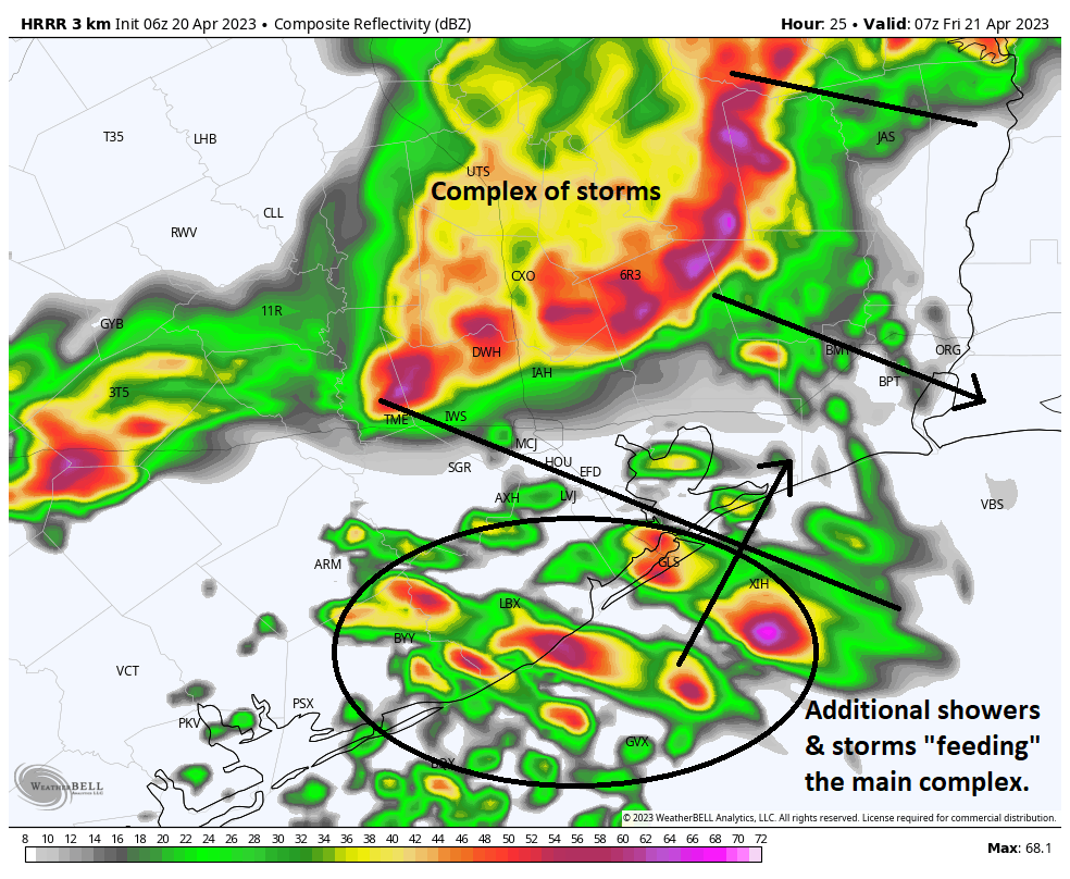
Main message: Phase one of storms mainly north and west of Houston will begin winding down this evening. The second phase of storms should be widespread and hit most of the area with heavy rain, lots of thunder and lightning, and potentially strong, gusty winds in the overnight hours. It would be a good idea to have a way to receive weather warnings overnight, just to be safe.
Details: Afternoon storms will also develop on Thursday out in Hill Country and along the I-35 corridor. That separate area of storms will likely congeal into a well-organized complex of storms that rushes south and east this evening. The bulk of that will pass along and north of I-10 around or after midnight. Additionally, new storms “feeding” the main complex will develop south of Houston and lift northward. This can be seen in the forecast radar from the HRRR model at 2 AM tonight. I annotated the two areas here.
Two areas of storms are likely to impact us overnight with many places seeing heavy rain, gusty winds, and a lot of lightning. A couple of these storms could become severe. (Weather Bell)
These types of setups are typically favorable to produce strong, gusty winds. Some of the storms developing to the south could become a bit severe as well, with hail or strong winds. Basically, all this adds up to a setup that is favorable to produce noisy weather in the overnight hours, probably beginning around or just before midnight north and west and then most of the rest of the areas between 12 and 3 AM. By 6 or 7 AM, most of the storms should be offshore.
Rain totals of 1 to 2 inches will be likely across much of the area. Some places will see less (especially southwest of Houston), while others could see more, especially east, northwest, and north of Houston. (Pivotal Weather)
Rain totals will probably average 1 to 2 inches for much of the area. The exceptions to this may be southwest of Houston. The heaviest activity may miss north and east of there, so rain totals risk coming in under an inch for places like Fort Bend County back through Wharton. Northwest of Houston and east of I-45 could see slightly greater amounts, as this is where storms will probably be heaviest.
Friday
Showers and storms should race offshore in the early morning. Typically, the atmosphere is pretty worked over after an event like this, so while there will continue to be a chance of showers or even a thunderstorm as the cold front approaches in the afternoon, the risk of anything significant appears to be on the low side right now. Expect gradual clearing and highs in the 80s Friday if the sun can break out for a time.
Saturday
Definitely the pick of the weekend. We expect morning lows in the 50s or low-60s, sunshine, and afternoon highs in the upper-70s. Weather for Taylor or the Dynamo match versus Inter Miami looks great.
Sunday
The second half of the weekend is a much trickier proposition. Morning lows will be in the 50s or low-60s. Then, there will be two forecasts for Sunday: One will be north of I-10, and the other will be south of I-10. Keep in mind that this is meant to be a generalization, not an exact demarcation.
For folks north of I-10, you will likely see clouds and perhaps a little sunshine. There is a slight chance of showers in the afternoon, especially the closer you are to Houston. Highs will be in the low to mid-70s depending on how much sun can break through.
Those of you south of I-10 should see clouds thicken up with highs in the low-70s. Showers and thunderstorms are likely to develop during the afternoon, especially the closer you are to Matagorda Bay. Rain could be heavy at times.
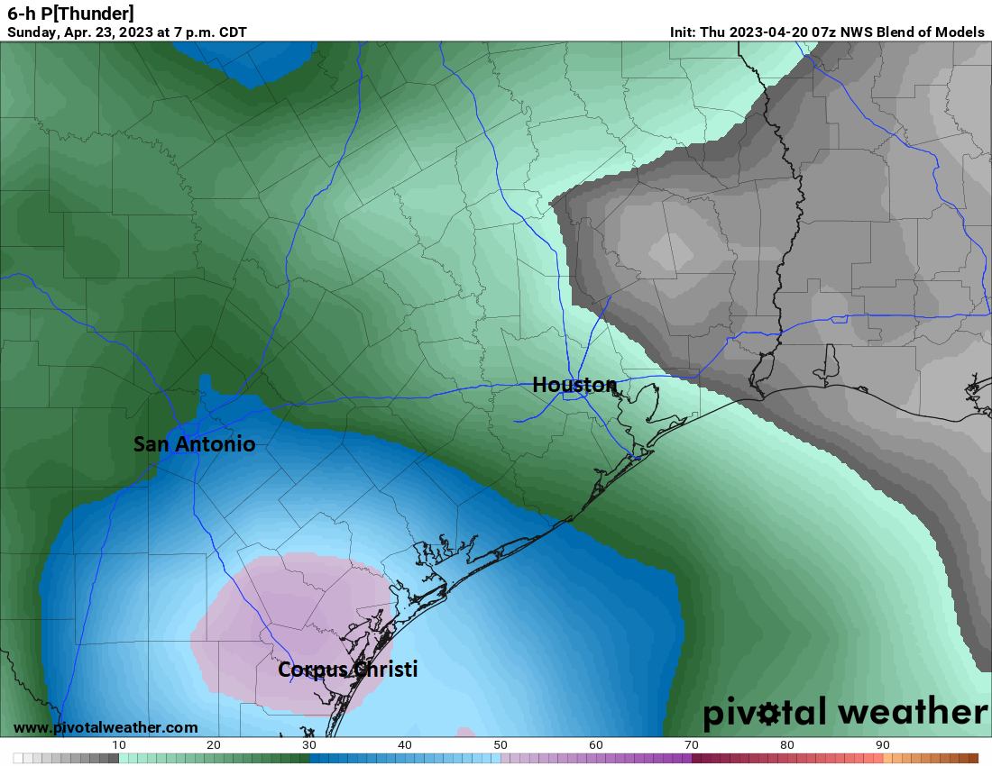
The probability of thunder on Sunday afternoon is highest in the Corpus Christi area, according to the National Blend of Models. That said, chances are not zero in the Houston area. (Pivotal Weather)
I would caution that there’s still a fair bit of uncertainty on the specifics of Sunday’s forecast, so if you have plans, be they T-Swift or otherwise, check back in with us tomorrow for the latest.
Early next week
The front half of next week looks generally unsettled with a chance of showers, albeit a fairly low one Monday and Tuesday. There may be a better chance of showers or storms Wednesday. Highs will be in the 70s and 80s and lows generally in the 60s.
Late next week & MS 150 preview
Presumably, Wednesday’s storms will herald a cold front that should bring in cooler, drier air for late next week. This would mean highs in the 70s and lows in the 50s or low-60s, along with low humidity. What does this mean for next weekend’s MS 150 ride across southeast Texas?
Usually when we get fronts like this in late April, the cool air stays a day or two, and then onshore flow resumes and we’re back to warm and humid. This front may have a little more “oomph” behind it, so I might be willing to say that Saturday would continue to be pleasant, with highs in the upper-70s to near 80, sunshine, and comfortably low humidity. It’s far too early to speculate much on wind, but this type of pattern would probably produce a light east or northeast wind, so almost a tail wind for Saturday if you’re leaving from Houston. I would assume that winds would be out of the south and a bit stronger on Sunday, with slightly higher humidity and highs in the 80s. For now, rain chances look low, but I have to caution that it’s still early. We will keep you posted!