Good Sunday to you. With the potential of a major hurricane in the Gulf in 3 days, we just want to post to reassure our Houston readers that this storm will not impact Texas and offer an update for our neighbors to the east.
Just to reemphasize, for Houston, we are in fine shape. The window of impacts from Ian has likely narrowed from east of New Orleans through most of Florida.
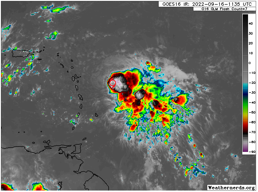
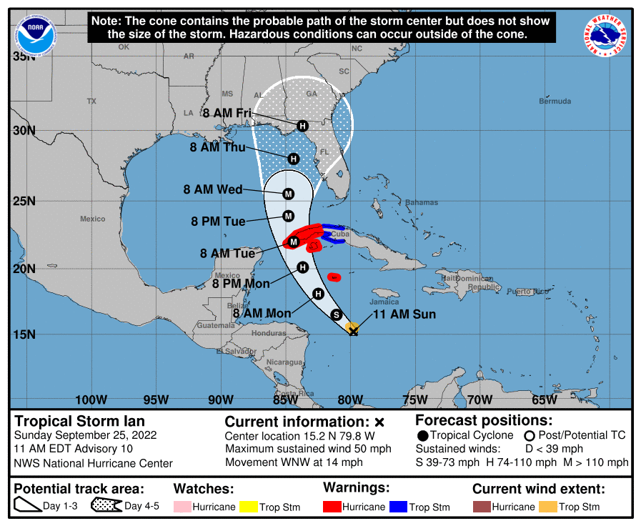
As of Sunday morning, Ian has maximum sustained winds of 50 mph. Reconnaissance aircraft traversing the storm are not finding anything super noteworthy this morning. Ian remains a tropical storm trying to organize itself. The satellite picture is less than overwhelming.

That said, with a generally favorable environment surrounding it, Ian should be able to rapidly intensify at some point in the next 36 hours. If Ian continues to struggle some into tomorrow, the odds of that drop but by no means does the lack of organization indicate much about the long term peak of Ian at this point. Rapid intensification happens…rapidly. Despite the raggedness at the moment, Ian is still likely to become a major hurricane as it moves into the southeast Gulf of Mexico.
What will impact Ian’s intensity at landfall is exactly where it tracks. If the storm turns right faster and plows into Fort Myers through Tampa, Ian will likely be near peak intensity as it does so, a really bad situation. If the storm heads more north toward the Big Bend or Apalachicola Bay, the storm should be a bit under peak intensity as it comes ashore. If the storm goes farther west toward Pensacola or Mobile, the hope would be that Ian would weaken even a bit faster. Why? Wind shear. That being said, if a more northerly/westerly track does occur, Ian will be expanding in physical size, meaning a larger wind field. While this wouldn’t be quite the same as another “I” storm we are familiar with (Ike, which also weakened on approach to landfall), the idea would be the same for Florida: A very strong, powerful storm increasing in size but weakening at landfall can still produce very damaging impacts, and whatever the “category” of the storm, folks in Florida should be taking this seriously.
So where will Ian go? That’s the million dollar question, and I have to say, the forecast track of Ian is fairly complicated this close to impact time. The National Hurricane Center outlook shows Ian coming in somewhere between roughly Fort Myers and Pensacola.
This is as good a forecast as any in my personal opinion, and I think it correctly splits the risks down the middle. If we look at a more complicated map of what we call a “super ensemble” of a bunch of different ensemble models, you get a very similar looking cone.
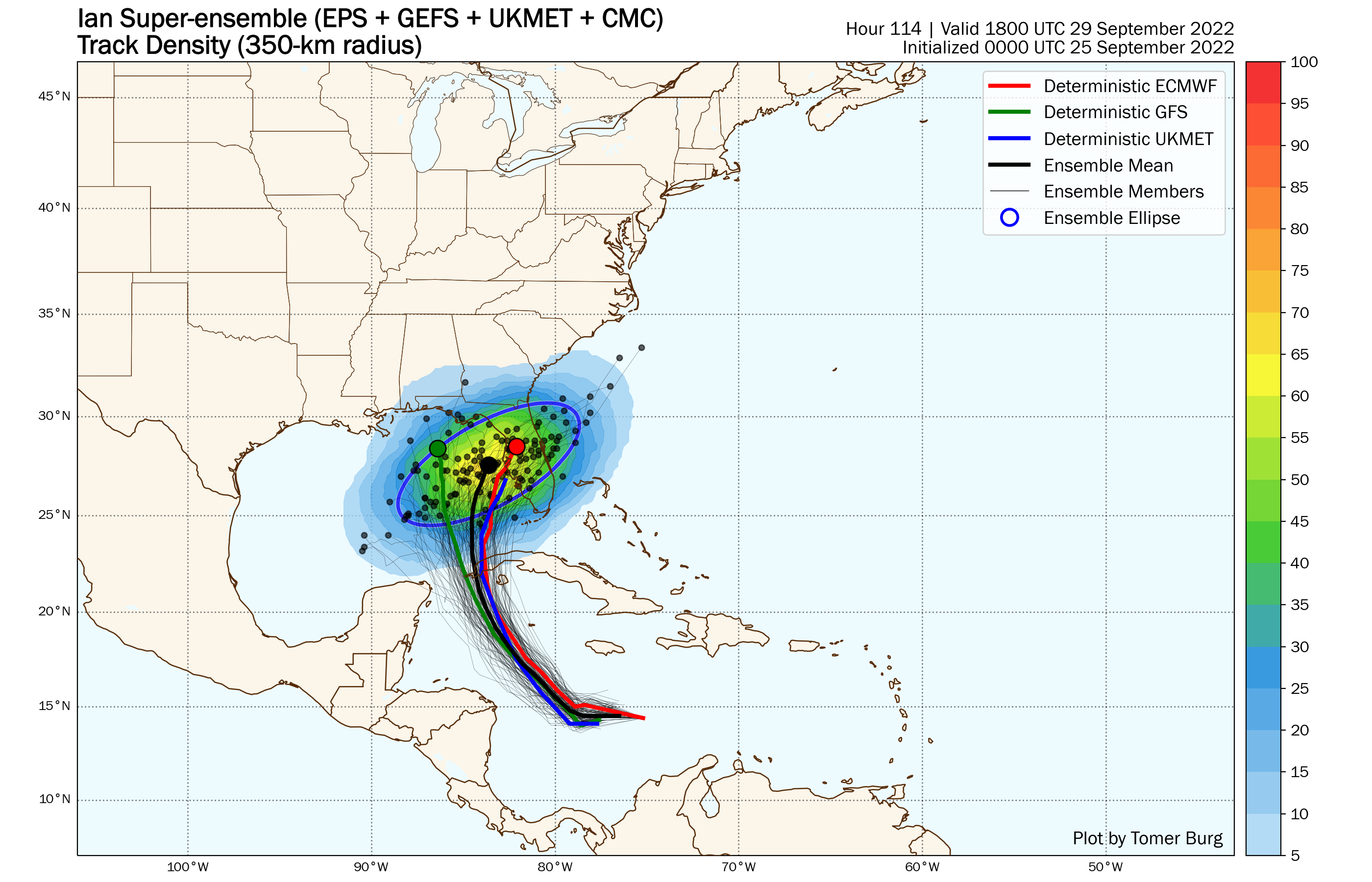
We use this approach to get a better sense of risk and/or consensus within the modeling itself. There are quite clearly two camps it seems; one that brings Ian near Tampa and another toward the Panhandle. But there is ample potential in between too. So this is another instance in which you have to look at the entire cone as being at risk versus just a point on a map. Hopefully we can narrow this further as today goes on so folks can begin to prepare adequately.
For now, if you know anyone in Florida or visiting Florida, they should be ready to act sooner than later. Impacts would hit southwest Florida by Wednesday or the Panhandle by later Thursday depending on the track.
As far as the Artemis I mission goes, the decision to delay the launch happened yesterday, and according to NASA, they will decide tonight on whether or not to rollback. Very difficult and consequential decisions here. Increasingly, the length of time needed to adequately prepare for storms and issue directives is longer than what is realistically possible from a weather prediction scenario, particularly when it comes to Gulf systems. This is another reason why hurricane preparedness plans are so important. You’ll almost always have less time than you think.
We’ll have another update on Ian tomorrow, as well as an update on the rest of our Houston area forecast. We are still on track for a cold front tomorrow that will usher in cooler and more comfortable weather probably through the weekend! Daytime highs will still be hot, near 90 or well into the 80s most days, but the humidity will be low, allowing for nighttime temperatures in the 60s and perhaps 50s inland. More tomorrow!