Welcome to another edition of our weekly tropical outlook. The last two hurricane seasons have been full of many quick developing, lower-end storms. Some folks deride the National Hurricane Center for “wasting time” naming these things, but if it looks like a duck and quacks like a duck, whether bloated, thin, short, tall, round, square, or what, it’s still a duck. And that’s why we have added another storm since last week.
If you blinked, you might have missed Tropical Storm Danny yesterday, but it formed off the coast of South Carolina, made landfall and weakened to a depression within about 12 to 18 hours. It wasn’t quite like Imelda, and its fast forward motion will keep it from becoming a Carolina or Georgia version of Imelda, but it went quickly, and it came from an area I didn’t even mention a week ago. So go the tropics.
Tropical outlook in a sentence
While there is one area in the Atlantic for us to monitor, it will likely face an uphill battle to make it to the Gulf in a position to develop any more significantly.
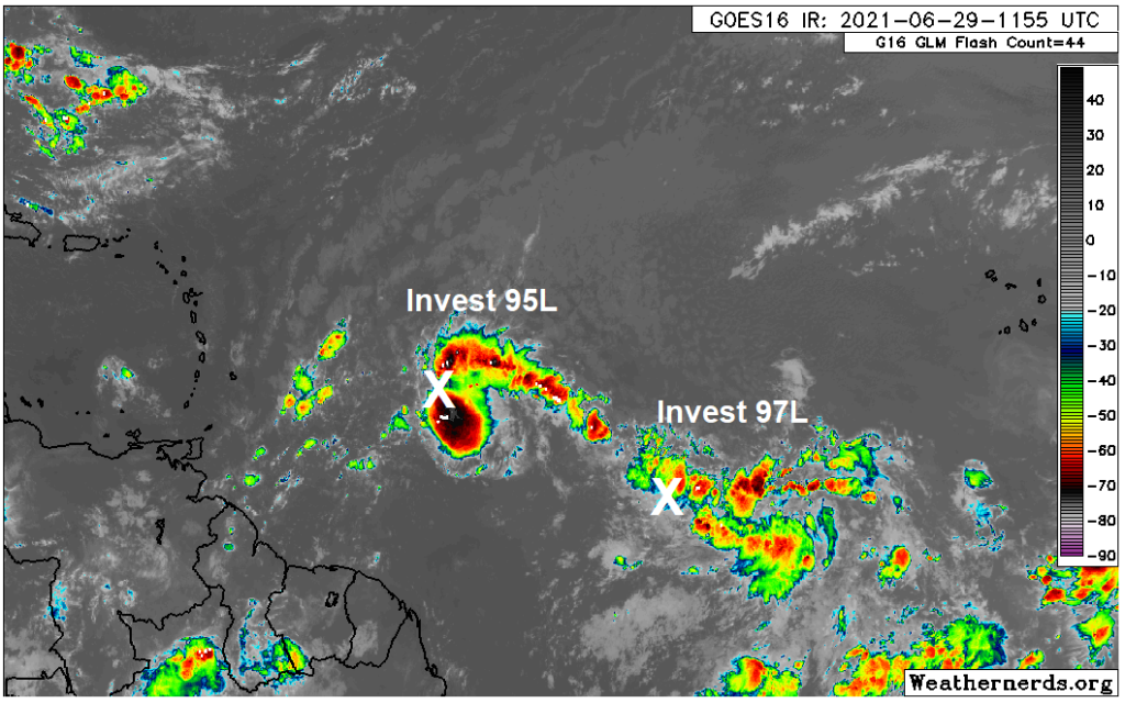
Invest 95L
The area people have been watching a good bit since last week is Invest 95L, which today does not pose much risk of making it to the Gulf. It will likely either stay disorganized and continue across the Caribbean (where it will face mountains of shear) or it will develop a little and get pulled north toward the Bahamas, Florida, or Eastern Gulf. Colloquially, some of us in meteorology will use the phrase “weaker, wester” to describe these things. It seems highly unlikely that 95L makes it to Houston. The National Hurricane Center has just lowered odds of development risk on 95L to 30 percent over the next 5 days.
Invest 97L
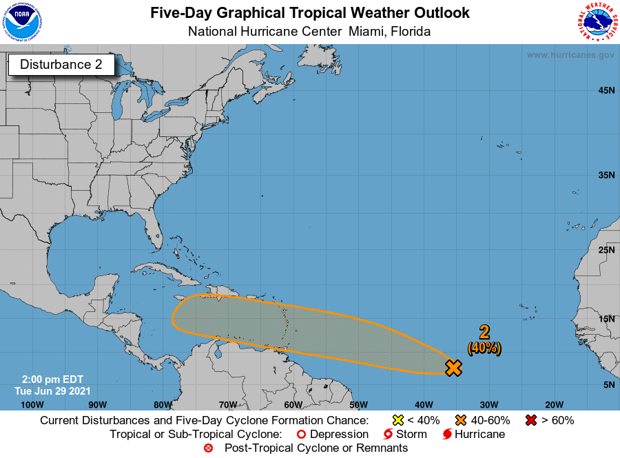
The one area I want to focus on is the new Invest 97L, which now has a 40 percent chance of developing over the next 5 days according to the National Hurricane Center (up from 20 percent this morning).
As you can see on satellite above, Invest 97L has some loose thunderstorm activity, but it is not yet organized. The one thing about Tropical Storm Danny: Say what you will about it being “pathetic” or whatever, but at least it had that swirly cinnamon bun look going for it yesterday. 97L is not there yet.
Invest 97L will be steered west or west-northwest around the periphery of high pressure in the Atlantic. Both key operational models, the Euro and GFS tend to buy into Invest 97L developing over the next three days. However, they differ significantly on *how* much development occurs. I’ve plotted the GFS and European models below, showing you what we call 850 mb vorticity. What? That’s a good map to look at to gauge where things stand with potential development risk. And you can indeed see both the GFS & Euro show ample “spin” (yellow & orange) and low pressure near the entrance to the Caribbean on Friday morning, with the Euro on the left and the GFS on the right.
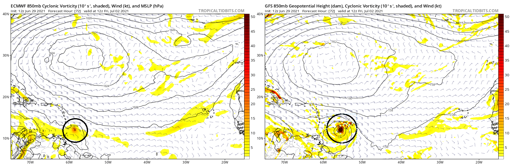
The difference is that the GFS is far, far more aggressive in organizing Invest 97L over the next 3 days. Why does this matter? Because the GFS has been the only model showing this coming to the Gulf as a significant storm. If it’s unrealistically strong 3 days from now, that doesn’t bode well for its accuracy on days 7 to 10. So right now, using context clues, there is a good shot we see the potential for a tropical depression or storm approaching the southern Lesser Antilles by the end of this week.
From there, this will have a mountain to overcome. The Caribbean is full of shear, and any system will not be greeted by favorable conditions on the other side of the islands. While the GFS keeps this going somewhat across the Caribbean, the Euro rips it to shreds. Neither model’s ensemble is particularly bullish on this system’s future either. So sitting here on Tuesday, I find it difficult to think that Invest 97L will make it to Texas as an organized tropical entity.
That said, the weather pattern over Texas is likely to say fairly cool and wet for most of the next 2 weeks. It gets tough to think that a tropical system makes it here as an organized system, but a bigger risk could be that the moisture gets here and exacerbates an already wet Texas.
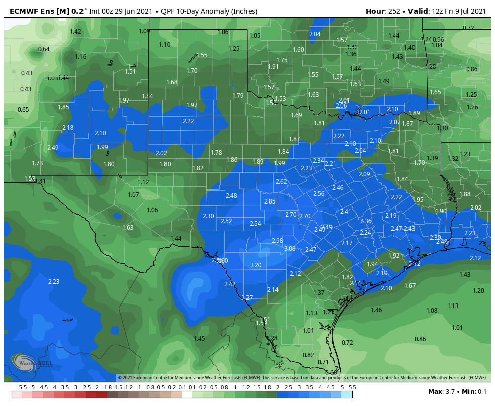
That’s a wet Texas to say the least. So the bottom line is that we’ll want to sort of watch this system for its moisture. But at least at this point there’s no reason to think it’s going to become a problem for us, and I can’t point you to any reliable, outlier model guidance that says it will. We will let you know if that were to change.
Beyond this, expect a quieter tropics for a little while, as the atmospheric background signals (what we often call the “intraseasonal phase” of the atmosphere) is fairly suppressed over the Atlantic basin, meaning it will inhibit storm formation. That doesn’t mean we won’t see a storm or two, but in general, storm development risk should be lower than it has been. This could allow for our first significant Saharan dust event of the summer as well sometime in mid-July. We will see.

Thanks so much for your weekly tropics update
“Swirly cinnamon bun look.” You are making me hungry 🤣🤣🤣.
Imelda flooded my house and we still aren’t fully recovered 1.5 years later. We didn’t flood in Tax Day, Memorial Day, or Harvey, but leave it to the City of Houston to “fix” the neighborhood’s drainage after Harvey and then we flood. I have no doubts it was because of the drainage changes that we flooded. So, thanks, Houston. We were fine and then 45 minutes later, we had water in the house. It came up so fast. I get unreasonably upset by any implication that Imelda was not a big deal, because it turned many people’s lives upside-down. Just not as many.
No question, and that wasn’t what I was implying at all. Thankfully (for them) it is moving, unlike Imelda, because it comes from the same ilk as that: Small, seemingly innocuous storm that slows down and leads to catastrophic flooding for a region. I actually believe Imelda’s name should have been retired, but apparently the powers that be didn’t agree. Alas. No, Imelda was horrible, full stop.
Hello, I have a trip plan for DR on tbe 10th do you think 97L is heading there?
It may pass nearby, but well before the 10th.
How would this affect Cancun next week?
Yes. Just kidding, sort of. The answer is, it might or might not. I wouldn’t be rescheduling a trip based on this right now, but I’d at least follow every couple days to make sure nothing major has changed. In a worst case scenario, I could see a quick moving tropical storm impact there. I don’t foresee hurricane there right now. Still, keep tabs on things, but don’t change plans at this point.
I.watched.a YouTube clip that had predictions of where the 2021 hurricanes will go this year. Do you want me to believe in those predictions or just rely on what the weather man say or you guys as well.